中甸-大具断裂南东段晚第四纪活动的地质地貌证据
【类型】期刊
【作者】李光涛,苏刚,程理,李峰,峰吴(中国地震灾害防御中心)
【作者单位】中国地震灾害防御中心
【刊名】地震地质
【关键词】 中甸-大具断裂;晚第四纪;滑动速率;活动性
【ISSN号】0253-4967
【页码】P545-560
【年份】2019
【期号】第3期
【期刊卷】1;|6;|7;|8;|2
【摘要】中甸-大具断裂南东段位于哈巴和玉龙雪山北麓,属于川西北次级块体西南边界,断裂总体走向310°~320°,是一条重要的边界断裂。了解该断裂的活动性质、活动时代和滑动速率等对分析川西北次级块体运动,研究该断裂与玉龙雪山东麓断裂的交切关系等问题具有重要意义。文中基于1︰5万活动断层地质填图,对断裂沿线地层地貌、陡坎地貌、地表破裂、典型断层剖面以及河流阶地等进行了详细的研究。研究表明:1)中甸-大具断裂南东段按几何结构、断错地貌表现、断裂活动性可分为马家村—大具次级段和大具—大东次级段。2)通过野外地质调查发现,马家村—大具次级段断错了全新世冲洪积扇,形成了地表破裂,为全新世活动段;而大具—大东次级段虽然也断错了晚更新—全新世地层,但其断错规模及滑动速率均较小,由此认为其全新世以来活动较弱。3)通过分析断裂沿线断层陡坎、水平位错及地表破裂等地质地貌问题,认为马家村—大具次级段的活动性质为右旋走滑兼正断,其晚更新世以来的垂直滑动速率为0. 4~0. 8mm/a,水平滑动速率为1. 5~2. 4mm/a;大具—大东次级段以右旋走滑为主、正断为辅,其晚更新世晚期以来的垂直滑动速率为0. 1mm/a。4)在大具盆地内发现的NW向地表破裂带的形成时代很年轻,不排除是1966年中甸6. 4级地震或1996年丽江7. 0级地震造成的地表破裂。
【全文】 文献传递
中甸-大具断裂南东段晚第四纪活动的地质地貌证据
0 引言
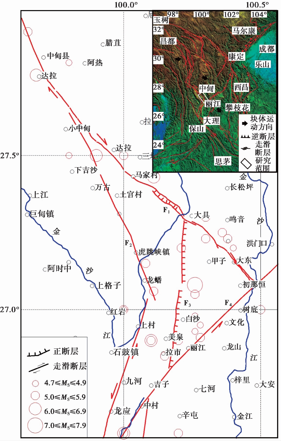
图 1 滇西北活动构造简图(断裂资料参考自文献(徐锡伟等, 2003))
Fig. 1 Diagram of active tectonics in Northwest Yunnan(fault data are referenced from XU Xi-wei et al., 2003).
F1中甸-大具断裂; F2中甸-龙蟠-乔后断裂; F3玉龙雪山东麓断裂; F4丽江-小金河断裂
云南中甸—丽江地区位于青藏高原东南隅横断山中段的三江地区, 为扬子地台、 松潘-甘孜地槽褶皱系和三江地槽褶皱系的结合部位, 该区是中国大陆构造最复杂、 地震频发的地区之一。印度板块的持续挤压造成了青藏高原的SE向逃逸运动, 从而形成了川滇菱形块体(李坪等, 1975; 阚荣举等, 1977; Tapponnier et al., 1982, 2001; Peltzer et al., 1988; Armijo et al., 1989; Lee et al., 1995; Hodeges et al., 2001; He et al., 2006)(图1)。而NE向的丽江-小金河断裂又将川滇菱形块体分为南、 北2个次级块体(徐锡伟等, 2003), 即北部的川西北次级块体和南部的滇中次级块体。中甸-大具断裂为川西北次级块体的西南边界断裂, 了解其活动性质、 活动时代及活动速率等问题, 对分析川西北次级块体的运动特征及构造演化具有重要作用。目前关于中甸-大具断裂的结构特征及活动性研究程度还很薄弱, 尤其是对其南东段活动性及分段缺少足够的认识, 活动时代及滑动速率多依据其西北段即德钦段来推断, 一直缺少地表调查的验证。
前人对滇西北地区金沙江河流的形成时代、 发展演化以及河流阶地等做过较多研究。 一些学者(张叶春等, 1998; Clark et al., 2004; 赵希涛等, 2006)认为滇西地区金沙江形成于早更新世甚至上新世时期。赵希涛等(2006)曾对大具盆地内第四纪沉积地层进行过详细研究, 认为大具盆地是一个完全由第四纪地层所构成的堆积盆地。沈军等(2001)指出, NW向的德钦-中甸-大具断裂为一条右旋走滑性质的断裂, 它与红河断裂构成了川滇菱形断块的南部边界。常祖峰等(2014)认为德钦-中甸-大具断裂最新活动时代为晚更新世—全新世, 该断裂是川滇菱形块体西北边缘的一条重要的NW向断裂, 它与金沙江断裂带一起, 共同构成了川滇菱形块体西北边界。
本文在前人工作的基础上, 通过 1︰5万活断层地质填图, 对该断裂的活动时代、 活动特征和分段性等问题进行了详细的分析与总结, 认为中甸-大具断裂南东段为全新世活动断裂, 并根据断裂活动性差异, 又将该断裂分为2个次级段。同时在大具盆地内发现了地表破裂, 并清理了断层剖面, 取得了更加直观、 可靠的证据, 认为断层为右旋走滑性质。通过遥感解译和实际测量, 结合年代学测年结果, 估算了其晚第四纪滑动速率, 并探讨其在川滇菱形块体运动中的地位和作用。对中甸-大具断裂南东段活动性和滑动速率的初步研究结果表明, 该断裂段是德钦-中甸-大具断裂的组成部分, 并不是玉龙雪山东麓断裂的北延部分。
1 区域地质背景
中甸-大具断裂位于丽江以北, 是云南省北西部边界附近的一条NW向断裂, 断裂西北起于中甸盆地南端, 向SE经木鲁谷顺哈巴雪山东北坡经熏洞、 哈巴到大具盆地, 横穿金沙江后沿西菜板至大东, 止于金沙江边, 全长约110km(图1)。
中甸-大具断裂西北与金沙江断裂相接, 向SE方向延伸, 在东南部与玉龙雪山东麓断裂相交, 并最终终止于金沙江边, 被丽江-小金河断裂截断。该断裂自上新世末期—早更新世开始形成, 经历了多次构造运动, 新构造时期以来, 该NW向走滑断裂右旋断错了大量地貌及水系, 与金沙江一起构成了川西北次级块体西边界, 其对该次级块体的顺时针旋转起到了重要的调节作用。
2 断裂地质地貌特征
中甸-大具断裂南东段西起马家村, 顺着沟谷线性地貌向SE方向延伸, 经哈巴乡、 大具乡、 大东乡至金沙江边, 断裂全长70km, 总体走向 N310°W(图2)。地形地貌线性特征明显, 多处发育断层陡坎及地表破裂。
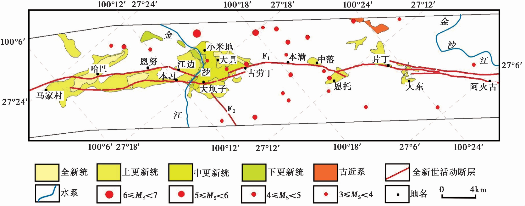
图 2 中甸-大具断裂南东段条带状地质简图
Fig. 2 Banded geological map of the southeastern section of the Zhongdian-Daju Fault.
F1中甸-大具断裂; F2玉龙雪山东麓断裂
2.1 断裂陡坎
在马家村—大具之间的哈巴雪山北麓断层陡坎地貌表现明显。断裂在此处以平行方式控制着哈巴断陷谷地两侧, 这2条平行断裂中, 南西侧断裂活动性明显, 断错了晚更新世冰碛物(图3), 形成了1条长约4.5km、 高约(14±2) m的断层陡坎, 陡坎连续性很好, 在遥感影像上也十分明显(图4), 一直向SE延伸至金沙江边。洪积扇陡坎内部多由砾石、 砂土及少量巨砾组成, 钙化胶结较硬, 吴中海等(2008)分析了该断层上、 下2盘顶部砂层中冰水扇样品的年龄, 所得结果为32.9~20ka。此外, 在个别部位的全新世冲洪积扇上也能见到位错现象(常祖峰等, 2014), 这表明全新世以来断裂在马家村—大具一带仍具有较强活动。
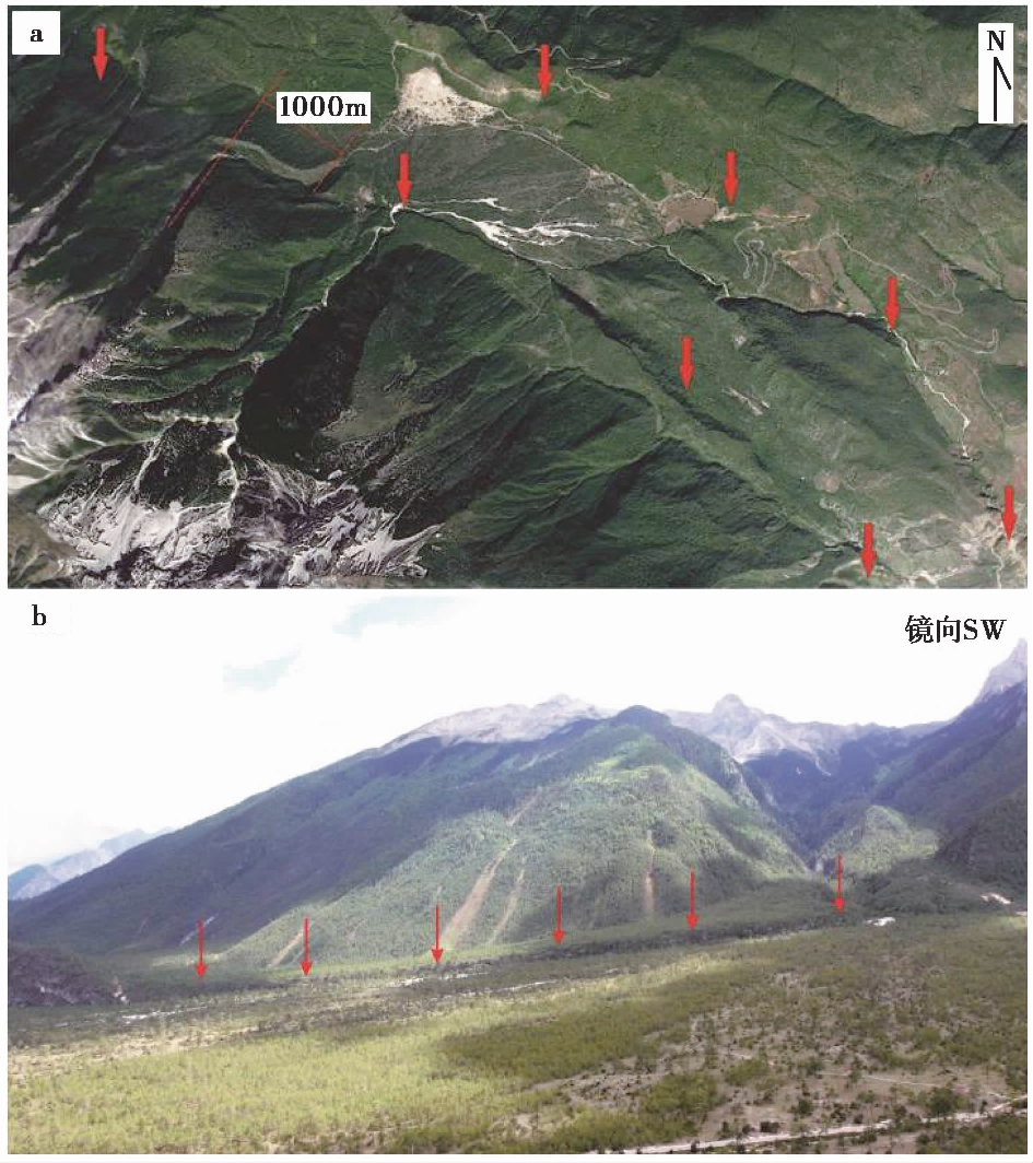
图 3 冲洪积扇陡坎地貌
Fig. 3 Scarp landform on alluvial-proluvial fan.
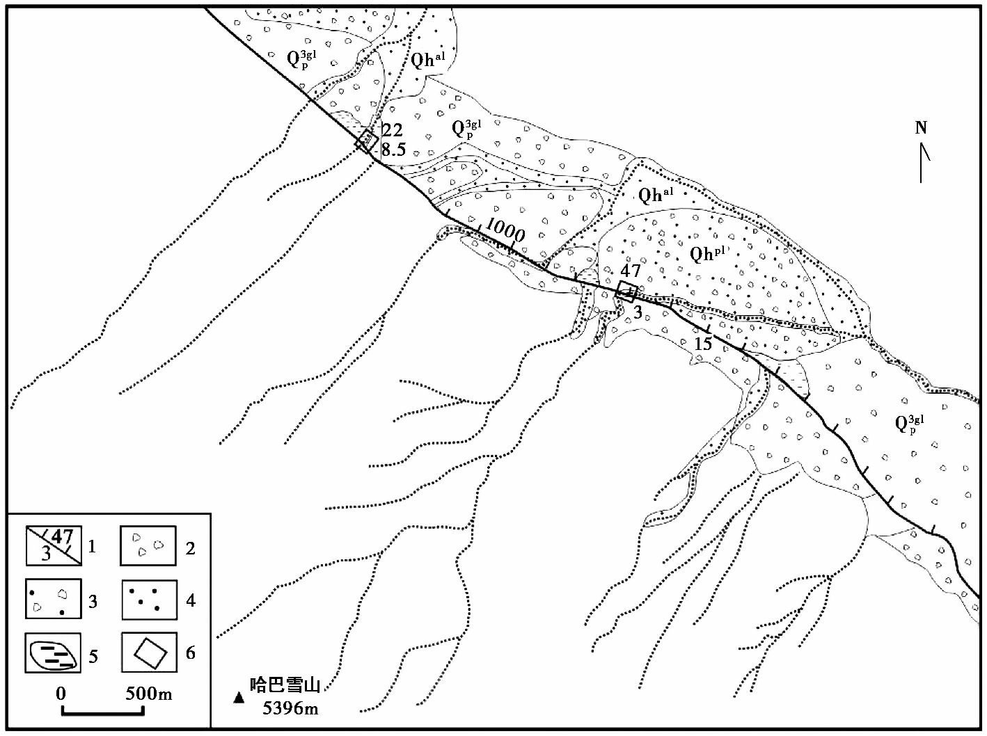
图 4 哈巴雪山附近断错地貌图
Fig. 4 The fault relief map near the Haba Snow Mountain.
1 断层陡坎(短线代表下降盘, 上方数字代表水平错距, 下方代表陡坎高度, 单位为m);2 冰碛物; 3 洪积物; 4 冲积物; 5 断塞塘; 6 微地貌测量区域
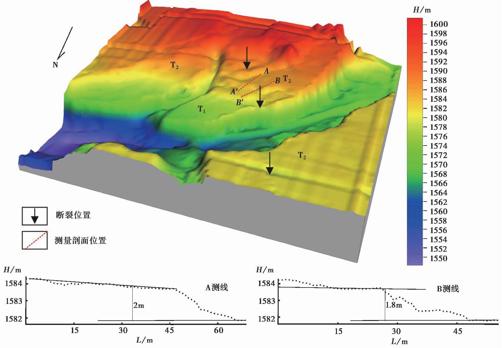
图 5 白水河二级阶地RTK测量图
Fig. 5 RTK map of the two levels of terraces of the Baishuihe River.
大具—大东一带为高山峡谷地貌, 很少发育第四纪地层, 只在大东乡附近发育了金沙江一级支流白水河, 白水河发育有二级阶地, 该二级阶地具有明显的二元结构, 下部为砾石层, 夹少量巨砾石, 上部为砂土夹少量砾石层。大具断裂横穿该河流阶地, 在河流两侧形成了线性冲沟地貌, 同时在二级阶地面上形成了陡坎, 通过RTK测量(图5)得到了阶地面形变数据, 断层垂直断错阶地面, 形成高约2m的陡坎, 在二级阶地砾石层上部取光释光测年样品, 得到其年龄为(22±2.2) ka。 该陡坎高度明显比马家村—大具之间的陡坎小很多, 表明晚更新世以来断裂在大具—大东一带的活动性比马家村—大具一带弱。
2.2 水平位错
同样在马家村—大具之间的哈巴雪山北麓, 冰水扇除受断裂断错形成陡坎的影响外, 同时受到断裂右旋走滑的影响, 使得山前的冰碛物和冲沟右旋位错。在陡坎左侧, 更高一级的冰水扇及冲沟被右旋错断约1km(图3a), 沿断裂形成了明显的深切沟谷; 而在陡坎连续性较好的冰水扇中发育的一条冲沟内同样见到水平位错现象, 通过测量, 该沟谷被右旋错断47m; 在山前发育的新一期全新世冰水冲积物内也存在右旋错断现象, 该冰水冲积物内的小冲沟由于受断裂右旋位错影响, 形成了2条断头沟, 经实地测量, A2断头沟最大位错距离为22m, A1断头沟则位错8.5m(图6)。对该区冰水扇发育情况进行分析并对冲沟位错进行测量及归纳, 认为该区最少存在3期冰水扇, 而断裂活动可能有4期。即最早一期冰水扇及冲沟被水平断错约1km; 第二期冰水扇及冲沟被水平断错约47m, 垂直断错约(14±2) m; 第三期冰水扇内的冲沟被水平断错2次, 第1次形成了位错为22m的断头沟, 第2次形成了位错为8.5m的断头沟。以上过程进一步证明了全新世以来断裂在马家村—大具一带具有较强活动性。
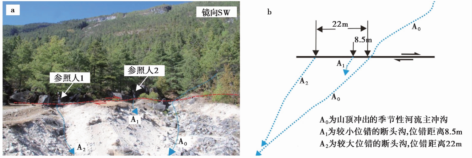
图 6 哈巴村冲沟位错及示意图
Fig. 6 Dislocation and schematic diagram of the gullies at Haba Village.
大具—大东一带水平位错地貌现象较少, 尤其是在全新世以来的冲洪积物内未见明显的水平位错, 只在文和村东的山脊处可见有3~4条冲沟发生右旋位错(图7), 最大位错距离为210m, 这可能是较老的一期位错, 从地质考察和遥感影像来看最新的活动应是从其西南侧的冲沟通过。
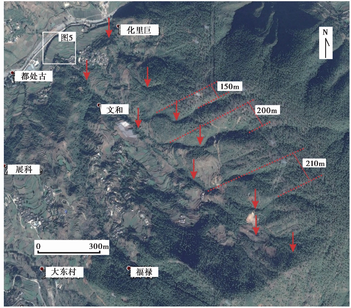
图 7 文和村东冲沟位错地貌图
Fig. 7 Geomorphologic map showing dislocation of the gullies at the east of Wenhe Village.
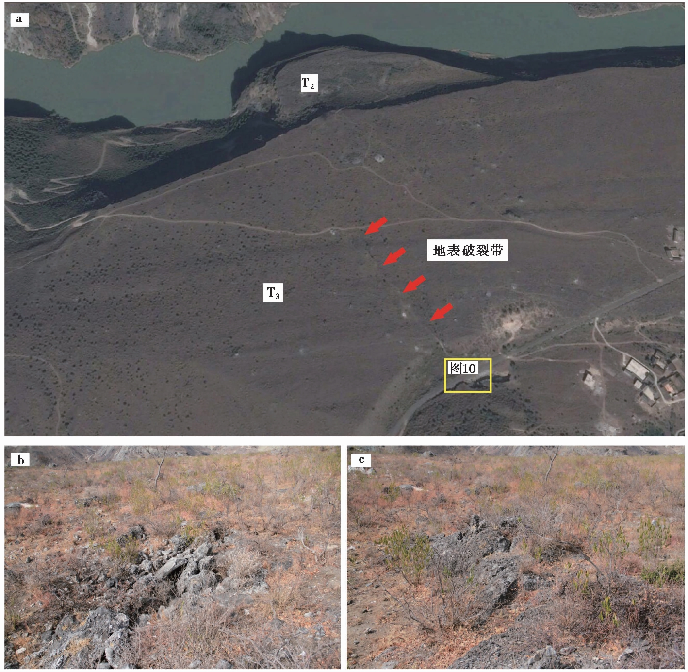
图 8 大具盆地地表破裂
Fig. 8 Surface rupture in Daju Basin.
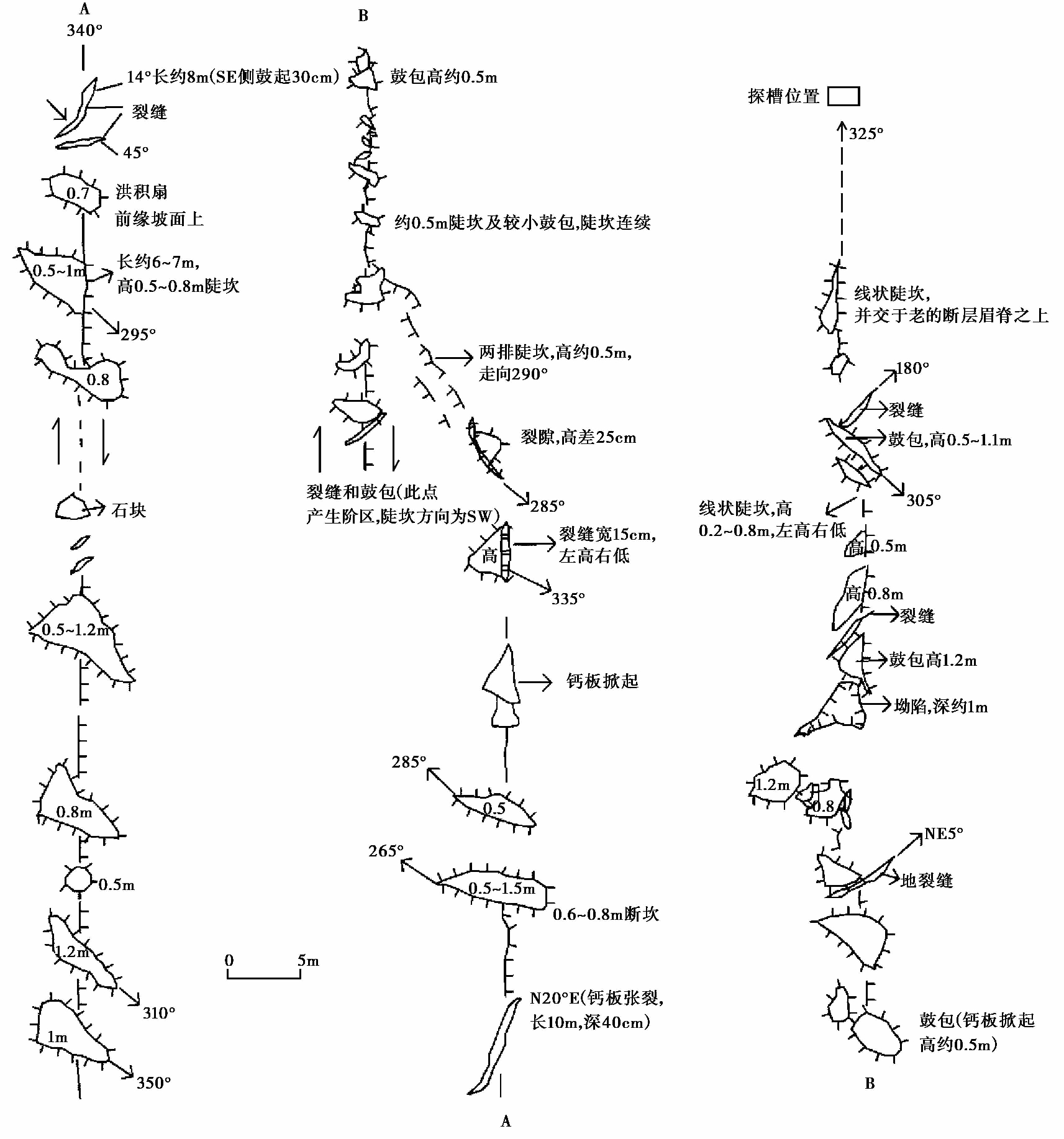
图 9 大具盆地地表破裂实际测量图
Fig. 9 Actual surveying map of surface rupture in Daju Basin.
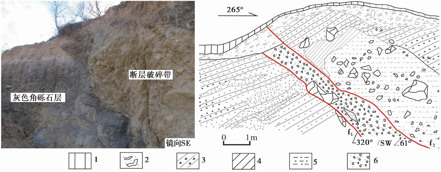
图 10 大坝子村断层剖面
Fig. 10 Fault section at Dabazi Village.
1 浅黄色表土层; 2 含较多姜石的浅黄色粉砂土层; 3 灰色角砾石层, 磨圆差; 4 浅灰绿色绿泥片岩残块;5 断层破碎带内物质, 以浅黄色碎石土夹砾石为主; 6 受断层影响的灰色较松散砾石
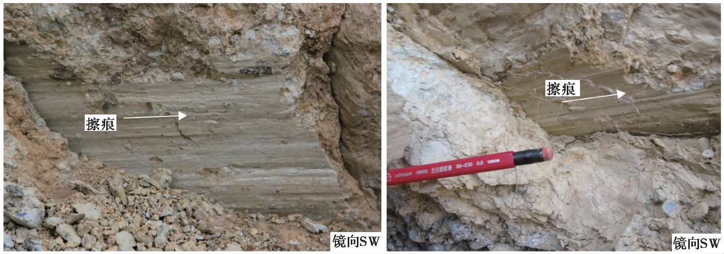
图 11 大坝子村断层剖面擦痕
Fig. 11 Slickensides on the fault section at Dabazi Village.
2.3 地表破裂
在马家村—大具之间的大具盆地内共发育有4级阶地, 在T3阶地上的大坝子村西北方向, 发现有1条呈NW向延伸的地震地表破裂带, 该破裂带在坚硬的厚约1m的由砂砾石钙化形成的T3阶地的硬地面上留下了清晰的痕迹, 盖板层或翘起鼓包、 或破裂、 或形成地裂缝, 并在局部形成了小的拉分 “凹陷”(图8, 9)。但该破裂带规模不大, 长约350m, 最宽处约60m, 高0.3~1.5m, 局部呈羽状排列或斜列, 以挤压型破裂为主, 通过观察这些翘起鼓包、 破裂或地裂缝, 排除了人为改造的可能。同时, 在地表破裂东南公路旁清理出断层剖面, 位于破裂带东南侧端点, 通过清理, 发现了断层剖面(图10), 断层切穿T3阶地砾石层, 近断面处发育挤压破碎带, 破碎带内物质以浅黄色碎石土夹砾石为主, 近断面处附有巨砾, 局部发育透镜体, 并有少量巨砾, 其顶部为强风化的绿泥片岩残块, 破碎带物质组成与两侧地层存在明显差别。详细观察后发现断面处发育近水平擦痕, 侧伏角15°~20°, 显示为右旋走滑为主, 兼有少量逆冲分量(图11)。根据断层剖面结构、 擦痕方向及地裂缝的斜裂关系和组合形态, 判断断层有多期活动, 且沿破裂带发生过明显的右旋走滑运动, 这与该段断裂的运动特征一致。
破裂带在大坝子南过将台河之后消失, 但沿大沟头村北侧的坡积与盆地面交界处有明显的线性特征, 继续向SE方向延伸。通过实地调查走访, 确认断裂在盆地延伸至沟口附近也曾出现过破裂及地裂缝。

图 12 片丁村地表破裂地貌
Fig. 12 Surface rupture landform at Pianding Village.
在大具—大东一带的麻地坪, 断裂继续向SE延伸, 此处断裂发育为平行的2条, 控制了沟谷内洪积扇发育的边界, 主断裂沿西侧发育。在片丁村北, 断裂通过处形成了槽谷地形, 在此槽谷内开挖了宽约60m的探槽, 发现了断层痕迹。此外, 通过实际走访与调查, 在该处发现1996年丽江地震曾经发育的地表破裂, 这些破裂断续分布, 规模较小, 局部形成陡坎(图12)。
3 断裂活动性分段
按前文所述, 根据断裂的几何结构、 地貌断错特征以及活动速率尤其是断裂的活动性等可将断裂划分为马家村—大具次级段和大具—大东次级段2段。各次级段活动特征如下。
3.1 马家村—大具次级段
该次级段北起马家村, 向SE经上羊房、 龙王边、 本习至大具乡, 全长32km。断裂总体走向NW, 倾向NE。地表线性特征清晰, 在金沙江西侧断裂断错了晚第四纪冰水扇及冲洪积地层, 形成了连续性较好的断层陡崖及多个冲沟位错, 位错距离从几十m至1km不等, 存在多期次活动, 表现为强烈的右旋走滑及正断特征; 在金沙江东岸大具盆地内部, 断层在局部地段形成了地表破裂, 并有断层剖面出露, 断面结构新鲜, 从地表破裂行迹及断层面擦痕分析, 也具有明显的右旋走滑特征。综上, 遥感解译、 实际测量和样品测年等结果表明, 该次级段在全新世以来的活动性仍较强。
3.2 大具—大东次级段
该次级段断裂由大具盆地东侧沟口的古劳丁村继续向SE延伸至恨都村, 全长45km, 走向320°, 主要为基岩山地, 断裂活动性在地貌表现上不甚明显。该次级段与马家村—大具次级段最主要的区别是仅个别地段存在地表破裂及断层陡坎现象, 且不连续、 规模较小, 也无明显的晚第四纪断层剖面出露。该段较明显的冲沟位错现象位于大东乡附近, 新活动的表现是在白水河二级阶地面上发现陡坎地貌, 高差约2m, 但陡坎高度明显比马家村—大具次级段低。综合分析该段断裂在地质地貌及位错量方面的特点, 认为大具—大东次级段最新活动时代也为全新世, 但活动性较弱。
4 结论与讨论
4.1 断裂位移速率
中甸-大具断裂南东段是位于哈巴和玉龙雪山北麓的NW向断裂, 该断裂归属于德钦-中甸-大具断裂还是玉龙雪山东麓断裂目前一直存在争论。众多研究者分别对这2条断裂进行了详细的研究(王运生等, 2000; 沈军等, 2001; 韩竹军等, 2004, 2005; 俞维贤等, 2004; Fan et al., 2006; 张西娟等, 2006; 石许华等, 2008; 吴中海等, 2008; Kong et al., 2009; 常祖峰等, 2014; 尹功明等, 2017)。我们暂且不考虑其归属问题, 只分析前人对这条断裂的滑动速率曾开展过的诸多研究。常祖峰等(2014)根据哈巴盆地二级支流的水平、 垂直位错值及其支流阶地的年代, 估算出其在距今5i000~6i000a以来的水平右旋滑动速率为1.7~2.0mm/a, 垂直滑动速率为0.6~0.7mm/a。吴中海等(2008)分析了哈巴盆地断层陡坎位错值, 得出该断裂全新世中期以来的垂直正断滑动速率为(0.5±0.2) mm/a。 尹功明等(2017)根据大具盆地T3阶地的垂直高差及其T2阶地的右旋位错值得到断裂逆冲速率和右旋滑动速率分别为2.37~3.94mm/a和5.03~8.37mm/a。沈军等(2001)根据大具盆地三级阶地面上发育的小冲沟和大东附近的冲沟在末次冰期晚冰阶以来的位错量, 得出这2个地点的平均错动速率分别为4~6mm/a和6~7mm/a。
本次工作对哈巴盆地内冰水扇发育情况及冲沟位错情况进行了系统的分析及归纳, 更加详实地记录了多期冰水扇和多个位错值, 并在冰水扇采集了年代样品, 但遗憾的是测得的年龄明显偏老。因此, 我们采用了吴中海等(2008)在该处取得的样品年龄, 该样品的采样流程比较系统, 所得年龄也比较可靠, 而根据该期冰水扇的水平位错约47m, 垂直位错约(14±2) m, 计算得到马家村—大具次级段晚更新世以来的垂直滑动速率为0.4~0.8mm/a, 水平滑动速率为1.5~2.4mm/a; 同时, 根据本文自身的年龄数据和位错值得到的大具—大东次级段晚更新世以来的垂直滑动速率为0.1mm/a。
总体而言, 虽然部分样品的年龄采用了前人成果, 但与前人的研究相比, 所得结果有相似也有差异。差异性可能主要缘于2个方面: 一是对于不同位置断裂位错量的估计有所不同; 二则对于断错地层的测年结果不同。当然, 更加系统地采集该处样品并利用更加多样的方法进行测年也是我们今后工作的重点, 这更有利于提高断裂活动期次及滑动速率分析的合理性和准确性。
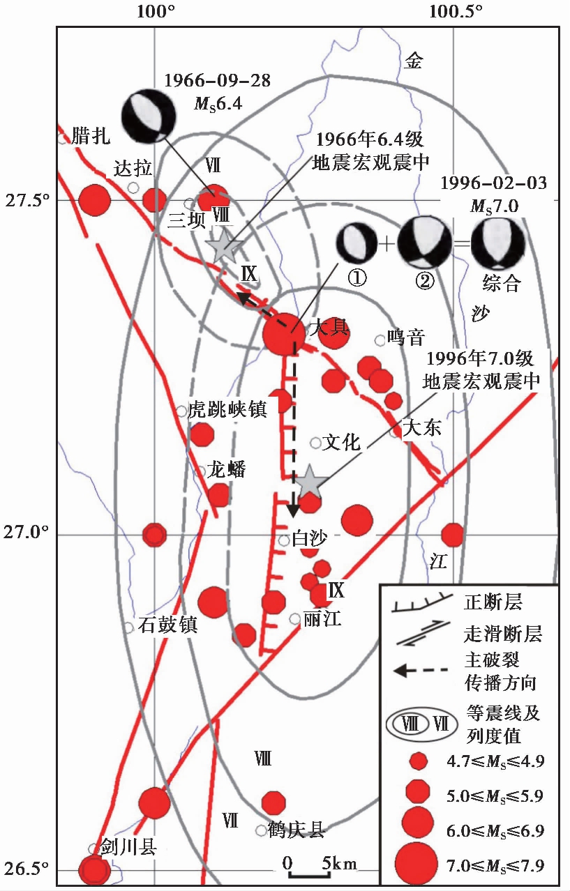
图 13 研究区地震构造图(改自吴中海等, 2008)
Fig. 13 Seismotectonic map of the study area
(adapted from WU Zhong-hai et al., 2008).
4.2 地表破裂可能的发生年代
文中所提到的地表破裂带形成于T3阶地的砾石层上, 该阶地砾石层直接出露于地表, 基本无覆盖层, 该级阶地年龄为33.8~20.3ka(Kong et al., 2009), 即形成于晚更新世晚期。对于该地表破裂带的形成时代, 主要从以下几个方面进行分析: 1)通过对破裂带东南侧断层剖面的分析(图10)可知断裂基本贯通, 其上部只覆盖着薄薄的松散浅黄色表土层, 该表土层由含细砾的风成砂土层构成, 根据土层结构判断其年龄较新。2)通过对该区地震活动的研究发现, 自886年以来, 该区只发生过2次较大的地震, 一次为1966年的6.4级中甸地震, 另一次为1996年的7.0级丽江地震。前者仪器震中位于大具盆地西北端, 其极震区和等震线长轴走向为NW; 后者仪器震中位于大具盆地金沙江畔, 宏观震中位于玉龙雪山东麓的黑水—玉湖之间, 其极震区和等震线长轴走向近SN(吴中海等, 2008)(图13)。3)通过对1996年丽江7.0级地震的主震反演、 等震线图和余震分布等资料的分析, 认为该地震存在2次破裂过程, 第一次破裂可能是由仪器震中(即大具盆地金沙江畔)沿中甸-大具断裂带向NW方向扩展, 终止于1966年中甸6.4级地震的震源区, 导致中甸-大具断裂的贯通; 第二次破裂由仪器震中沿玉龙雪山东麓断裂由北向南破裂, 这是7.0级地震的主破裂面(王绍晋等, 1997; 徐扬等, 1998)(图13)。
综上所述, 该地表破裂带形成时代很年轻, 此处只发生过2次较大的地震, 即1966年中甸6.4级地震和1996年丽江7.0级地震, 且2次地震均形成过NW向的地表破裂带。因此, 不排除该破裂带是1966年中甸6.4级地震或1996年丽江7.0级地震形成的破裂。
4.3 结论
(1)中甸-大具断裂南东段根据其地质、 地貌及活动性等特征, 又可分为马家村—大具和大具—大东2个次级段。
(2)通过野外地质调查发现, 马家村—大具次级段断错了全新世冲洪积扇, 并形成了地表破裂, 为全新世活动段。而大具—大东次级段虽然也断错了晚更新世—全新世地层, 但其断错规模及滑动速率均较小, 故认为其全新世以来活动较弱。
(3)根据探槽开挖及地质、 地貌等的测量与测年数据等结果, 得到大具断裂南东段马家村—大具次级段主要表现为右旋走滑兼正断特征, 其晚更新世以来的垂直滑动速率为0.4~0.8mm/a, 水平滑动速率为1.5~2.4mm/a。大具—大东次级段以右旋走滑为主, 正断为辅, 其晚更新世以来的垂直滑动速率为0.1mm/a。
(4)在大具盆地内发现的NW向地表破裂带形成时代很年轻, 不排除是1966年中甸6.4级地震或1996年丽江7.0级地震造成的地表破裂。
致谢 审稿专家对论文提出了宝贵意见; 文中的光释光样品年代由国土资源部海洋地质实验检测中心测试获得。在此一并表示感谢!
常祖峰, 张艳凤, 李鉴林, 等. 2014. 德钦—中甸—大具断裂晚第四纪活动的地质与地貌表现 [J]. 地震研究, 37(1): 46—52.
CHANG Zu-feng, ZHANG Yan-feng, LI Jian-lin, et al. 2014. The geological and geomorphic characteristic of Late Quaternary activity of the Deqin-Zhongdian-Daju Fault [J]. Journal of Seismological Research, 37(1): 46—52(in Chinese).
韩竹军, 虢顺民, 向宏发, 等. 2004. 1996年2月3日云南丽江7.0级地震发生的构造环境 [J]. 地震学报, (4): 410— 418.
HAN Zhu-jun, GUO Shun-min, XIANG Hong-fa, et al. 2004. Seismotectonic environment of occurring of the February 3, 1996 Lijiang M=7.0 earthquake, Yunnan Province [J]. Acta Seismologica Sinica, (4): 410— 418(in Chinese).
韩竹军, 向宏发, 虢顺民. 2005. 滇西北丽江盆地北部区第四纪时期的左旋剪切拉张 [J]. 科学通报, 50(4): 356—362.
HAN Zhu-jun, XIANG Hong-fa, GUO Shun-min. 2005. Sinistral shear and extension of the northern section of Lijiang Basin in northwest Yunnan in Quaternary [J]. Chinese Science Bulletin, 50(4): 356—362(in Chinese).
阚荣举, 张四昌, 晏凤桐, 等. 1977. 中国西南地区现代构造应力场与现代构造活动特征的探讨 [J]. 地球物理学报, 20(2): 96—109.
KAN Rong-ju, ZHANG Si-chang, YAN Feng-tong, et al. 1977. Present tectonic stress field and its relation to the characteristics of recent tectonic activity in southwestern China [J]. Chinese Journal of Geophysics, 20(2): 96—109(in Chinese).
李坪, 汪良谋. 1975. 云南川西地区地震地质基本特征的探讨 [J]. 地质科学, (4): 308—326.
LI Ping, WANG Liang-mou. 1975. Exploration of the seismo-geological features of the Yunnan-West Sichuan region [J]. Scientia Geologica Sinica, (4): 308—326(in Chinese).
沈军, 汪一鹏, 任金卫. 2001. 中国云南德钦—中甸—大具断裂带第四纪右旋走滑运动 [M]//见: 马宗晋, 汪一鹏, 张燕平编. 青藏高原岩石圈现今变动与动力学. 北京: 地震出版社.
SHEN Jun, WANG Yi-peng, REN Jin-wei. 2001. Quaternary dextral strike-slip movement of Deqin-Zhongdian-Daju Fault in Yunnan Province, China [M]//MA Zong-jin, WANG Yi-peng, ZHANG Yan-ping eds. Study on the Recent Deformation and Dynamics of the Lithospheric of Qinghai-Xizang Plateau. Seismological Press, Beijing(in Chinese).
石许华, 王二七, 王刚, 等. 2008. 青藏高原东南缘玉龙雪山(5 596m)晚新生代隆升的侵蚀与构造控制作用 [J]. 第四纪研究, 28(2): 222—231.
SHI Xu-hua, WANG Er-qi, WANG Gang, et al. 2008. Late Cenozoic uplift of the Yulong Snow Mountain(5 596m), SE Tibetan Plateau, caused by erosion and tectonic forcing [J]. Quaternary Sciences, 28(2): 222—231(in Chinese).
王运生, 王士天, 李渝生. 2000. 滇西北玉龙雪山隆升机制 [J]. 山地学报, 18(4): 313—317.
WANG Yun-sheng, WANG Shi-tian, LI Yu-sheng. 2000. The uplift mechanism of Mt. Yulong Snow Mountain, northwest of Yunnan [J]. Journal of Mountain Science, 18(4): 313—317(in Chinese).
王绍晋, 龙晓帆, 罗淑进. 1997. 丽江地震序列的震源机制、 发震应力场和破裂特征 [J]. 地震研究, 20(1): 26—34.
WANG Shao-jin, LONG Xiao-fan, LUO Shu-jin. 1997. The focal mechanism, seismogenic stress field and rupture characteristics of the Lijiang earthquake sequence [J]. Journal of Seismological Research, 20(1): 26—34(in Chinese).
吴中海, 张永双, 胡道功, 等. 2008. 滇西北哈巴-玉龙雪山东麓断裂的晚第四纪正断层作用及其动力学机制探讨 [J]. 中国科学(D辑), 38(11): 1361—1375.
WU Zhong-hai, ZHANG Yong-shuang, HU Dao-gong, et al. 2008. Late Quaternary normal faulting and its kinematic mechanism of the eastern piedmont fault of the Haba-Yulong Mountains in northwestern Yunnan, China [J]. Science in China(Ser D), 38(11): 1361—1375(in Chinese).
徐锡伟, 闻学泽, 郑荣章, 等. 2003. 川滇地区活动块体最新构造变动样式及其动力来源 [J]. 中国科学(D辑), 33(S1): 151—162.
XU Xi-wei, WEN Xue-ze, ZHENG Rong-zhang, et al. 2003. A new tectonic style for active blocks of Sichuan-Yunnan region and its power source [J]. Science in China(Ser D), 33(S1): 151—162(in Chinese).
徐扬, 菊地正幸, 苏有锦. 1998. 1996年2月3日云南丽江地震震源过程的体波反演 [J]. 地震学报, 20(2): 113—117.
XU Yang, Masayuki K, SU You-jin. 1998. Body waveform inversion for the source process of the February 3, 1996 Lijiang, Yunnan earthquake [J]. Acta Seismologica Sinica, 20(2): 113—117(in Chinese).
尹功明, 苏刚, 丁锐, 等. 2017. 南玉龙雪山东麓断层的运动性质及其地貌意义 [J]. 第四纪研究, 37(2): 250—259.
YIN Gong-ming, SU Gang, DING Rui, et al. 2017. Kinematic property of the eastern piedmont fault of Yulong Mountains and its implication for geomorphology in Yunnan, southwest of China [J]. Quaternary Sciences, 37(2): 250—259(in Chinese).
俞维贤, 王彬, 谢英情, 等. 2004. 玉龙雪山周缘主要断裂的断层泥中石英碎砾表面SEM特征与丽江地震 [J]. 地震研究, 27(1): 81—87.
YU Wei-xian, WANG Bin, XIE Ying-qing, et al. 2004. Discussion on the Lijiang earthquake and the SEM characteristics of surface of quartz gravels in the gouge of main faults around the Yulong Snow Mountain [J]. Journal of Seismological Research, 27(1): 81—87(in Chinese).
张西娟, 曾庆利, 马寅生. 2006. 玉龙-哈巴雪山断块差异隆升的基本特征及其地质灾害效应 [J]. 中国地质, 33(5): 1075—1082.
ZHANG Xi-juan, ZENG Qing-li, MA Yin-sheng. 2006. Basic characteristics of the differential uplift of the Yulong-Haba block and its geological hazard effect [J]. Geology in China, 33(5): 1075—1082(in Chinese).
张叶春, 李吉均, 朱俊杰, 等. 1998. 晚新生代金沙江形成时代与过程研究 [J]. 云南地理环境研究, 10(2): 45—50.
ZHANG Ye-chun, LI Ji-jun, ZHU Jun-jie, et al. 1998. Studies on development of Jinshajiang River during Late Cenozoic [J]. Yunnan Geographic Environment Research, 10(2): 45—50(in Chinese).
赵希涛, 张永双, 胡道功, 等. 2006. 云南丽江地区大具盆地早更新世金沙江砾石层的发现及其意义 [J]. 地质通报, 25(12): 1381—1386.
ZHAO Xi-tao, ZHANG Yong-shuang, HU Dao-gong, et al. 2006. Discovery of Early Pleistocene gravels of the Jinsha River in the Daju Basin, Yunnan, China and its significance [J]. Geological Bulletin of China, 25(12): 1381—1386(in Chinese).
Armijo R, Tapponnier P, Mercier J, et al. 1989. Late Cenozoic right-lateral strike-slip faulting in southern Tibet [J]. Journal of Geophysical Research: Solid Earth, 94(B3): 2787—2838.
Clark M K, Schoenbohn L M, Royden L H, et al. 2004. Surface uplift, tectonics, and erosion of eastern Tibet from large-scale drainage patterns [J]. Tectonics, 23(1): TC1006.
Fan C, Wang C, Wang S F, et al. 2006. Structural interpretation of extensional deformation along the Dali fault system, southeastern margin of the Tibetan Plateau [J]. International Geology Review, 48(4): 287—310.
He H L, Ran H L, Yasutaka I. 2006. Uniform strike-slip rate along the Xianshuihe-Xiaojiang fault system and its implications for active tectonics in southeastern Tibet [J]. Acta Geologica Sinica, 80(3): 376—386.
Hodeges K, Hurtado J, Whipple K. 2001. Southward extrusion of Tibetan crust and its effect on Himalayan tectonics [J]. Tectonics, 20(6): 799—809.
Kong P, Na C, Fink D, et al. 2009. Moraine dam related to late Quaternary glaciation in the Yulong Mountains, southwest China, and impacts on the Jinsha River [J]. Quaternary Science Reviews, 28(27-28): 3224—3235.
Lee T Y, Lawyer L A. 1995. Cenozoic reconstruction of southeast Asia [J]. Tectonophysics, 151:85—138.
Peltzer G, Tapponnier P. 1988. Formation and evolution of strike-slip faults, rifts, and basins during India-Asia collision: An experiment approach [J]. Journal of Geophysical Research: Solid Earth, 93(B12): 15085—15117.
Tapponnier P, Peltzer G, Le Dain A Y, et al. 1982. Propagation extrusion tectonics in Asia: New insights from simple experiments with plasticine [J]. Geology, 10:611— 616.
Tapponnier P, Xu Z Q, Roger F, et al. 2001. Oblique stepwise rise and growth of Tibet plateau [J]. Science, 294(5547): 1671—1677.
LATE QUATERNARY ACTIVITY OF THE SOUTHEASTERN SECTION OF ZHONGDIAN-DAJU FAULT
The southeast section of Zhongdian-Daju Fault is located in the northern part of Haba and Yulong Snow Mountain, belonging to the southwestern boundary of the secondary block in northwestern Sichuan, an important boundary fault striking 310°~320° on the whole. The nature of the fault, the age of its activity and the slip rate are of great significance for the analysis of the secondary block movement in the northwestern Sichuan and the intersection relationship with the eastern piedmont fault of Yulong Mountains.
Based on the 1︰5 million-scale active fault geological mapping, this paper studies in detail the stratigraphic landform, scarp landform, surface rupture, typical fault profile and river terrace along the fault. Based on the research results, we divide the southeastern section of Zhongdian-Daju Fault into two sub-segments, the Majiacun-Daju sub-segment and the Daju-Dadong sub-segment, according to the geometric structure, fault landforms and fault activity.
(1)Fault scarp: In the Majiacun-Daju sub-segment, the fault parallelly controls the two sides of the Haba fault depression. It cuts the late Pleistocene moraine deposits, forming a fault scarp of about 4.5km long and(14±2)m high. The continuity of the scarp is very good, and it is also very obvious in the remote sensing image. In the Daju-Dadong sub-segment, a scarp with a height of about 2m is formed, and an optical luminescence dating sample is collected from the upper part of the gravel layer on the second-order terrace to obtain an age of(22±2.2)ka.
(2)Horizontal dislocation: In the Majiacun-Daju sub-segment, through the analysis of the development of outwash fans in the area and the measurement and induction of the gully dislocations, it is considered that there are at least three stages of outwash fans developed in the area and there may be four phases of faulting. That is, the earliest-stage outwash fan and gully are horizontally dislocated about 1km; the second-stage outwash fan and gully are horizontally dislocated about 47m, and the vertical dislocation is about(14±2)m; the gully in the third stage outwash fan is horizontally dislocated twice, the first dislocation formed a beheaded gully with a dislocation of 22m, and the second formed a beheaded gully with a dislocation of 8.5m. It is further proved that the fault has strong activity since the Holocene in the Majiacun to Daju area. In the Daju-Dadong sub-segment, there are no obvious horizontal dislocations in the alluvial deposits since the Holocene. Only 3~4 gullies are found to be offset right-laterally in the ridges east of Wenhe Village, with the maximum dislocation of 210m, which may be the older phase dislocation.
(3)Surface rupture: In the northwest direction of Dabazi Village on the T3 terrace in the basin between Majiacun and Daju, an earthquake surface rupture zone is found, extending in the NW direction. The rupture zone left clear traces on the about 1m-thick, hard T3 terrace surface formed by calcification of sand gravels, and the overburden either upwarps and bulges, or ruptures, generates ground fissures, or forms small pull-apart “depressions” locally. However, the rupture zone is not large in size, about 350m long, 60m wide at the widest point, and 0.3~1.5m high. It is partially en-echelon or obliquely arranged, dominated by compressive ruptures. Through observation, the possibility of artificial transformation is ruled out for these upwarping bulges, ruptures or ground fissures. The fault section is found in the southeast direction of the rupture zone. The slickensides at the section show that the fault is dominated by right-lateral strike-slip with a small amount of thrust. In the eastern sub-segment, only intermittently distributed surface ruptures are found in the northern part of the village, and the scale is small.
In summary, through the field geological survey, it is found that the Majiacun-Daju sub-segment is a Holocene active segment. Though the Daju-Dadong sub-segment also offset the late Pleistocene to Holocene strata, it is considered that its Holocene activity is weak in terms of either the dislocation amount or the slip rate of this segment.
By analyzing the geological and geomorphological evidences, such as fault scarps, horizontal dislocation and surface ruptures along the fault, it is considered that the Majiacun-Daju sub-segment is a right-lateral strike-slip fault with a normal faulting component, and its vertical slip rate since the late Pleistocene is(0.4~0.8)mm/a, the horizontal slip rate is 1.5~2.4mm/a. The Daju-Dadong sub-segment is dominated by right-lateral strike-slip with a normal faulting component, and its vertical slip rate since the late Late Cenozoic is 0.1mm/a.
The formation of the NW-trending surface rupture zone found in the Daju Basin is very young, where there are only two major earthquakes, namely, the MS6.4 1966 Zhongdian earthquake and the 1996 Lijiang MS7.0 earthquake, and both earthquakes produced NW-oriented surface rupture zones. Therefore, it cannot be ruled out that the rupture zone is a product of the 1966 Zhongdian MS6.4 earthquake or the 1996 Lijiang MS7.0 earthquake.
