青藏高原西北部晚第四纪以来的隆升作用——来自西昆仑阿什库勒多级河流阶地的证据*
【类型】期刊
【作者】潘家伟,李海兵,孙知明,司家亮,裴军令,刘栋梁,MarieLuce CHEVALIER(大陆构造与动力学国家重点实验室中国地质科学院地质研究所;中国地质科学院地质力学研究所)
【作者单位】大陆构造与动力学国家重点实验室中国地质科学院地质研究所;中国地质科学院地质力学研究所
【刊名】岩石学报
【关键词】 青藏高原;隆升;晚第四纪;河流阶地;宇宙核素测年
【资助项】受国家自然科学基金项目 (41202156、41221061);中国地质调查局地质大调查项目 (1212011121267);行业基金项目 (201011034);中国地质科...
【ISSN号】1000-0569
【页码】P2199-2210
【年份】2019
【期号】第6期
【期刊卷】1;|3;|7;|8;|4;|5;|2
【摘要】青藏高原的隆升是新生代最壮观的地质事件,关于青藏高原隆升研究一直是地学界的研究焦点。河流阶地的发育记录了丰富的构造运动和气候变化的信息,近年来被广泛应用于构造运动和气候演变的研究,但前人研究的河流阶地基本分布在青藏高原的周缘,阶地的形成可能是气候与构造运动共同作用的结果。本文通过高分辨率卫星影像的解译,在青藏高原内部的西昆仑阿什库勒地区发现了多达七级的河流阶地。对该处河流阶地结构、沉积特征、几何特征的研究表明该阶地是典型的构造成因阶地。野外利用全站仪对河流阶地地貌形态进行了精细的测量,获得了各级阶地的拔河高度分别为4~5m(T1)、9~10m(T2)、16~18m(T3)、28~31m(T4)、45~48m(T5)。通过宇宙成因核素10Be测年方法对各级阶地面的暴露年龄进行了测定,获得了各级阶地的形成时代分别为7.7±0.7ka(T1)、32.7±3.1ka(T2)、53.6±2.5ka(T3)、115.7±23.2ka(T4)、166.8±10.4ka(T5)、19.5±8.5ka(T6)。由此确定了晚第四纪166.8ka以来不同时期的河流下切速率总体介于0.2~0.35mm/yr,该速率代表了青藏高原西北部晚第四纪166.8ka以来的平均隆升速率。
【全文】 文献传递
青藏高原西北部晚第四纪以来的隆升作用
——来自西昆仑阿什库勒多级河流阶地的证据*
摘 要 青藏高原的隆升是新生代最壮观的地质事件,关于青藏高原隆升研究一直是地学界的研究焦点。河流阶地的发育记录了丰富的构造运动和气候变化的信息,近年来被广泛应用于构造运动和气候演变的研究,但前人研究的河流阶地基本分布在青藏高原的周缘,阶地的形成可能是气候与构造运动共同作用的结果。本文通过高分辨率卫星影像的解译,在青藏高原内部的西昆仑阿什库勒地区发现了多达七级的河流阶地。对该处河流阶地结构、沉积特征、几何特征的研究表明该阶地是典型的构造成因阶地。野外利用全站仪对河流阶地地貌形态进行了精细的测量,获得了各级阶地的拔河高度分别为4~5m(T1)、9~10m(T2)、16~18m(T3)、28~31m(T4)、45~48m(T5)。通过宇宙成因核素10Be测年方法对各级阶地面的暴露年龄进行了测定,获得了各级阶地的形成时代分别为7.7±0.7ka (T1)、32.7±3.1ka (T2)、53.6±2.5ka (T3)、115.7±23.2ka (T4)、166.8±10.4ka (T5)、19.5±8.5ka (T6)。由此确定了晚第四纪166.8ka以来不同时期的河流下切速率总体介于0.2~0.35mm/yr,该速率代表了青藏高原西北部晚第四纪166.8ka以来的平均隆升速率。
关键词 青藏高原;隆升;晚第四纪;河流阶地;宇宙核素测年
青藏高原是具有特殊几何形态和地貌景观,正在快速隆起的,世界上最高、最厚和最新的大陆地块,具有十分复杂的地质构造、物质组成、流变学特征和独特的深部地球物理状态,被认为是大陆动力学研究的最佳实验室和窗口(许志琴等, 2007)。新生代以来,印度板块自南向北俯冲至欧亚大陆之下,之后持续的会聚与碰撞造成了青藏高原的隆升(Molnar et al., 1975, 1993; Tapponnier and Molnar, 1976; Tapponnier et al., 1986, 2001; Yin and Harrison, 2000; Royden et al., 2008)。青藏高原隆升这一新生代最壮观的地质事件影响了资源的再分配及生存环境的变化,并在高原内部及边缘诱发了至今仍异常活跃的地震灾害,因此青藏高原隆升研究一直是地学界的研究焦点。
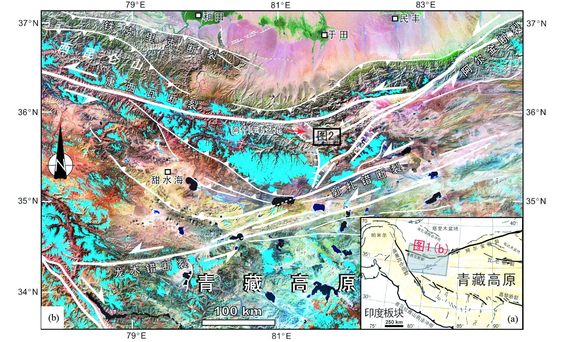
图1 青藏高原西部活动构造(a)及阿什库勒邻区Landsat卫星影像构造解译(b)
Fig.1 Active tectonics in the western Tibetan Plateau (a) and tectonic interpretation of Landsat image of the adjacent area of the Ashikule basin (b)
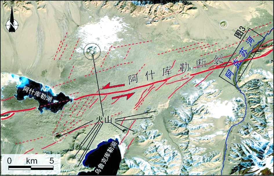
图2 阿什库勒盆地东端SPOT卫星影像及其活动构造解译
图中虚线圈示阿什库勒断裂两侧火山口位置;右侧黑色方框为图3位置
Fig.2 SPOT image and its tectonic interpretation of the eastern part of the Ashikule basin
在青藏高原西北部,西昆仑山与塔里木前陆盆地之间过渡的山前陡坡地貌带是高原边缘地形变化最剧烈的地带之一,海拔高度从高原内部的4000~5000m迅速下降到塔里木盆地西南部的约1200m(潘家伟等, 2007, 2009; 刘栋梁等, 2011)。这种强烈的地形变化反映了青藏高原西北部晚新生代以来经历了强烈的隆升作用,并保留了高原晚新生代隆升剥露的丰富信息,使该地区也成为研究青藏高原西北部晚新生代隆升作用和高原地貌形成与演化的关键地区。 国内外许多学者在西昆仑、帕米尔地区通过低温热年代学方法(裂变径迹、40Ar/39Ar、U-Th/He等方法)对晚新生代的冷却剥露过程进行了研究(Arnaud et al., 1993; 王军等, 1998; 王彦斌等, 2001; 万景林和王二七, 2002; 王永等, 2002; Wang et al., 2003; 黎敦朋等, 2007, 2010; 曹凯等, 2009; Cowgill 2010; Sobel et al., 2011, 2013; Cao et al., 2013a, b),并探讨了该地区新生代的构造隆升。另有学者通过对西昆仑山前新生代地层沉积特征的研究(金小赤等, 2001; 刘训等, 2002; Jin et al., 2003; 郑洪波等, 2002, 2003; Zheng et al., 2000, 2003, 2006; 李喜臣等, 2005; 司家亮等, 2007)对西昆仑地区晚新生代隆升的起始时间和过程进行了的探讨。然而,上述关于青藏高原西北部隆升作用的研究均是百万年时间尺度的研究,而对于该地区晚第四纪隆升作用的研究仍然存在空白。通过对高分辨率遥感卫星影像的解译,我们发现在青藏高原西北部阿什库勒地区阿克苏河两岸发育多达7级的河流阶地。不同于山前地区的河流阶地,阿克苏河7级阶地发育在青藏高原内部,接近河流源头处,周围地形平坦,高差不大, 阶地的形成受气候变化和其他因素的影响很小,而与构造隆升有密切的关系,包含了青藏高原西北部的隆升信息。本文通过对该处河流阶地特征的分析,结合阶地地形测量和阶地面宇宙成因核素10Be定年结果,对青藏高原西北部晚第四纪的隆升作用进行了探讨。
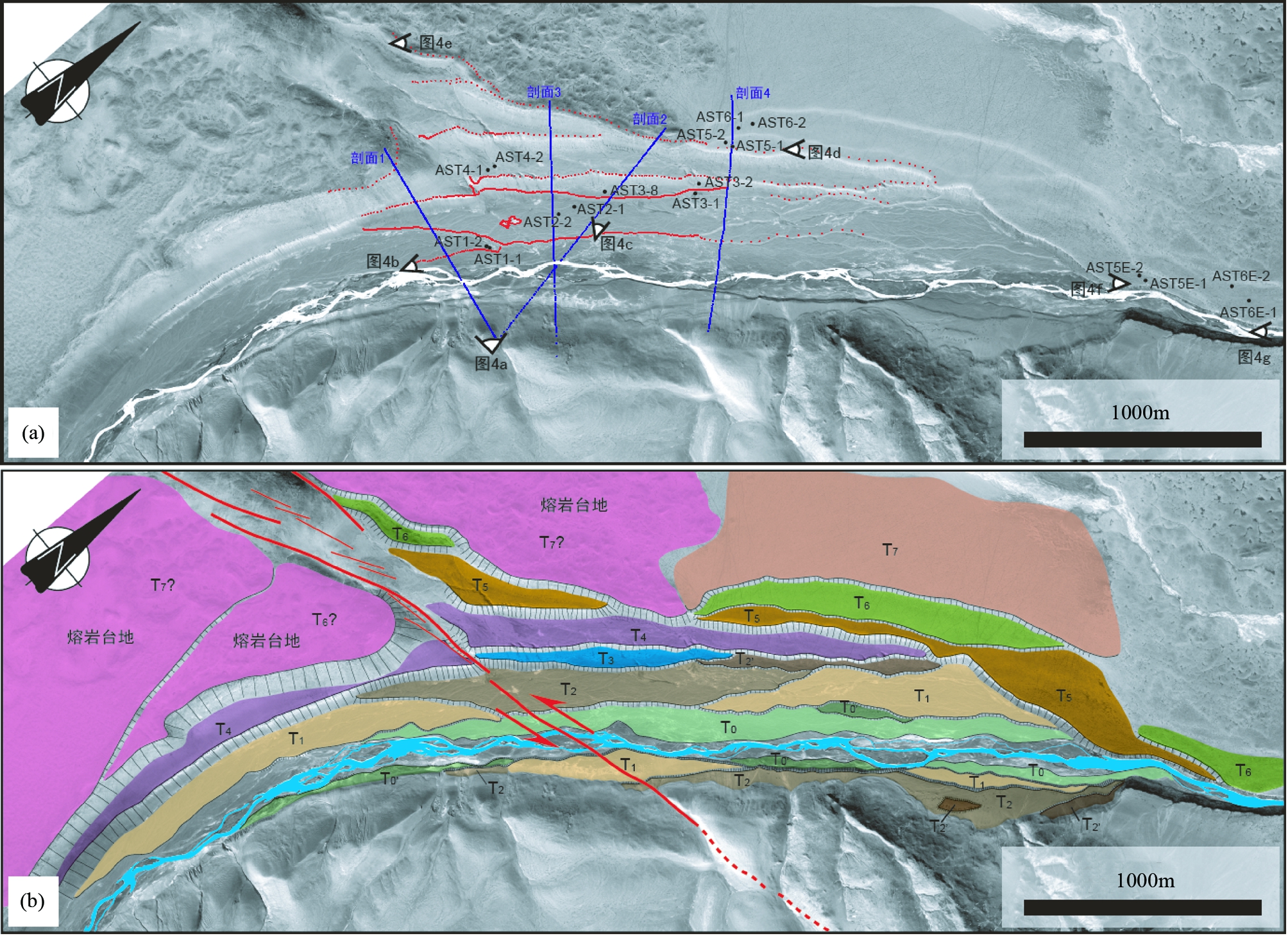
图3 阿克苏河阶地QuickBird卫星影像(a)及其地貌解译(b)
图(a)中红色点为野外全站仪测量记录的河流阶地陡坎边缘;蓝色点组成的线为图5中全站仪测量的河流阶地剖面位置;黑色点及文字为宇宙成因核素10Be年龄样品采集位置和样品号;白色眼睛符号指示图4中照片的拍摄位置和角度
Fig.3 QuickBird satellite image (a) and its interpretation of the Akesu River site (b)
1 研究区概况
阿什库勒地区(阿什库勒盆地)位于青藏高原西北部山脉走向发生转变,阿尔金断裂与康西瓦断裂转弯和连接的关键桥梁地带(图1a, b),是阿尔金断裂系走滑与转弯过程中局部拉张形成的走滑盆地(李海兵等,2006),同时这一地区也是青藏高原西北部一个重要的应力集中区。阿什库勒盆地地势北高南低,西高东低,平均海拔约4800m,最低点海拔4683m(阿什库勒湖处),整体轮廓近似菱形。在阿什库勒盆地内出露有著名的青藏高原北部第四纪活火山群——阿什库勒火山群(图2)。这些火山主要分布于盆地南部阿什库勒断裂两侧相伴的张剪性带中,火山活动与阿尔金断裂带的走滑活动有关。在阿什库勒地区,阿尔金断裂带数条重要的活动断裂在此汇聚集中(图1b)。NWW走向的康西瓦断裂与NEE走向的阿什库勒断裂在此相交,南西侧阿什库勒断裂又与郭扎错、龙木错断裂呈雁行状排列,除上述主要的走滑断裂外,在北侧山前还存在着逆冲断裂作用,南侧发育数条活动正断裂(图1b),他们都共同属于阿尔金断裂系,是在局部不同的应力状态下发育的不同性质断裂。由于阿什库勒盆地位于青藏高原内部高海拔无人区,自然环境恶劣,野外工作条件艰苦,因此研究程度很低,之前只在20世纪有零星的火山地质考察(邓万明, 1989; 刘嘉麒和买买提依明, 1990)。2008年阿什库勒地震(于田地震)(Li et al., 2010; Xu et al., 2013)的发生使该地区得到了更多的关注。
阿克苏河发源于阿什库勒盆地南侧的西昆仑山冰川,是克里雅河上游的一条支流。在阿什库勒盆地的东端(图2),阿克苏河由南向北流动转向由西向东流动处,两岸发育了至少7级河流阶地(图3)。虽然多级河流阶地在山前地区较为常见,但阿克苏河阶地发育在青藏高原内部,多达7级的河流阶地在青藏高原内部的其他地方还没有发现过,这为我们研究青藏高原西北部晚第四纪隆升作用提供了很好的机会。
2 阶地发育特征
如前面所述在阿什库勒盆地东端,阿克苏河两岸发育了至少7级河流阶地,如果算上高河漫滩和一些陡坎高度1m左右的次级阶地的话,那么该地区河流阶地可以划分出8~10级。在高分辨率遥感卫星影像的解译分析和野外详细观察与精细测量的基础上,我们将该处河流阶地划分为主要的7级和一些次级阶地(图3、图4a)。其中在河流西北岸阶地保存较好,T1至T7均可以见到,东南岸阶地发育程度较差,仅保留有T1、T2残留。
高河漫滩(T0)在河流两岸分布广泛(图3b),地形较为平坦,主要为砾石堆积(图4b),砾石成分主要为花岗岩和石英,黑色火山岩较少,砾石磨圆程度较好,直径5~20cm不等。
T1阶地在河西北岸阿什库勒断裂切过河流处被侵蚀,没有保存,但在断裂南北两侧保存较好(图3b),河流东南岸也有保存,阶地面宽阔平坦,由磨圆较好的砾石和泥沙堆积而成(图4b),地表较为新鲜,有植被发育,阶地拔河高度约5m左右。
T2阶地在河西北岸发育完整,在河东南岸也有保存,阶地面平坦宽阔,拔河高度在10m左右,阶地面上也可见到砾石,但分选、磨圆较差,部分砾石呈棱角状,大小不一(图4c)。
T3阶地在该地区保存较差,仅在河西北岸有小块残余(图3b),地面主要为风化的浮土和棱角状的碎石覆盖,大的砾石较少,挖开阶地陡坎后可见到砾石堆积。
T4阶地在河北西岸保存均较好,较为连续(图3b),地表风化程度较高,基本为浮土和棱角状小碎石覆盖,并可见到黑色的熔岩碎块,挖开阶地陡坎后也可见到明显的河流相砾石及泥砂沉积物。
T5阶地主体沉积物与T4类似,地表风化严重,浮土层较厚(图4d),但在北东端河口变窄处可看到T5地表薄层风化沉积物之下出露厚层的第四纪火山岩基岩(图4f)。
T6阶地在接近阿什库勒断裂处北侧仅保留有一小块残余(图3b),地表已有大量熔岩覆盖,往东侧河流下游方向T6保存较好,但地表沉积物与西侧差异较大,主要为风化的浮土和较小的砾石与熔岩碎块。断裂南侧的T6为熔岩台地,基本被第四纪火山熔岩覆盖。
T7阶地在靠近断裂处两侧均为熔岩台地(图3b、图4e),地形起伏不平,拔河高度较大,东侧下游方向保存的T7则为平坦的地形,地表被风化的浮土和砾石碎片覆盖。
野外利用全站仪穿越阿克苏河河流阶地测量了4条地形剖面(图5,各剖面位置见图3a),其中剖面1(图5a)和剖面2(图5b)斜切河流,剖面3(图5c)及剖面4(图5d)为垂直于阿克苏河流向的河流阶地横剖面。剖面1中记录的T0、T0′、T1、T2、T6的拔河高度分别为1m、3m、4~5m、10.5~11m和~105m(图5a)。剖面2中T1、T2、T3、T4、T7级阶地面的拔河高度分别为4~5m、7~8m、~13m、~23m、~45m(图5b)。在剖面3(图5c)中,T2、T3、T4、T5、T7级阶地面的拔河高度分别为9~10m、16~18m、28~31m、45~48m和~77m。剖面4(图5d)中T1、T2、T3、T4、T5、T6、T7级阶地面的拔河高度分别为4~5m、7~8m、9~10m、18~20m、31~32m、~35m和~36m。
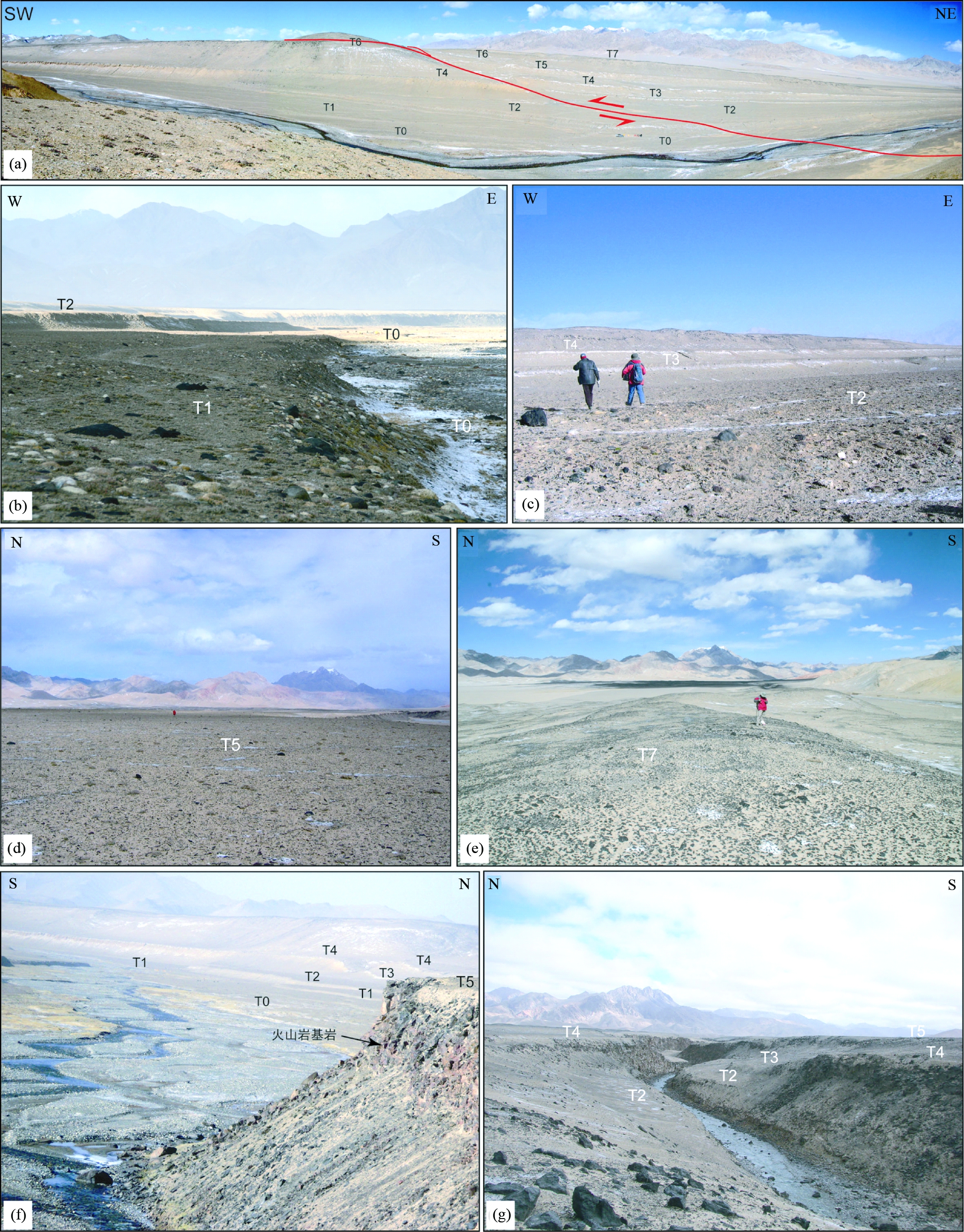
图4 阿克苏河多级阶地野外照片
(a)-阿克苏河7级阶地全景照片; (b)-T0和T1阶地上的砾石堆积; (c)-T2阶地面砾石及砂土沉积; (d)-T5阶地面上浮土及熔岩碎块覆盖; (e)-T7阶地面上熔岩台地; (f)-T5阶地面北东端出露的第四纪火山岩基岩; (g)-研究点北东侧河谷出露的火山岩基岩显示各级阶地均为基座阶地
Fig.4 Field photos show the characteristics of the terraces of the Akesu River
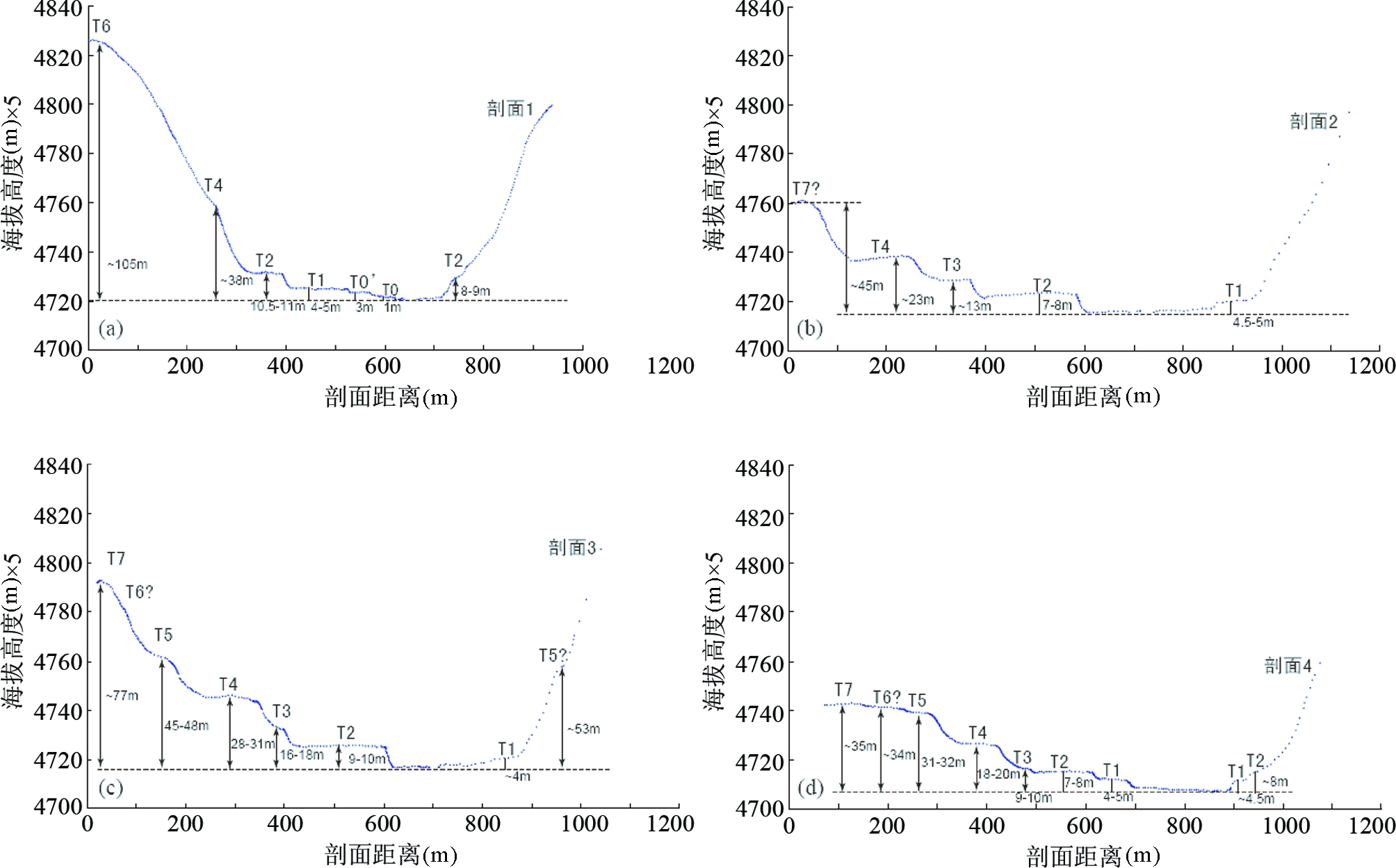
图5 全站仪测量的阿克苏河河流阶地地形剖面(各剖面位置见图3a)
Fig.5 Topographic profiles of Akesu River terraces surveyed with a Total Station (locations are seen in Fig.3a)
除了上述跨越河流阶地的4条剖面外,野外还沿着各级阶地的陡坎边缘进行了全站仪测量(图3a中红色点)。为了更清楚的看到各级阶地的对应关系和阶地间高差,我们将这些野外测量点与跨越河流阶地的剖面分别平行于河流走向(图6a)和垂直于河流走向(图6b)进行了投影,投影结果见图6。从平行于河流总体走向的投影图中(图6a)可以明显看出阿克苏河T1阶地拔河高度约4m,T2/T1阶地陡坎高度约5~6m,T2′/T1陡砍高度约5.5m,T3/T2陡坎高度约6~8m,T4/T3陡砍高度约7~14m不等,T5/T4陡砍高度在靠近南西端约17~18m,靠近北东端约12~13m。平行于河流走向的投影图显示阿克苏河河床和各级阶地纵向坡度基本保持稳定,同时从低级阶地向高级阶地坡度有变高的趋势。阶地陡坎边缘投影和跨过河流阶地的横剖面显示了良好的对应关系,共同揭示了阿克苏河阶地的几何特征。
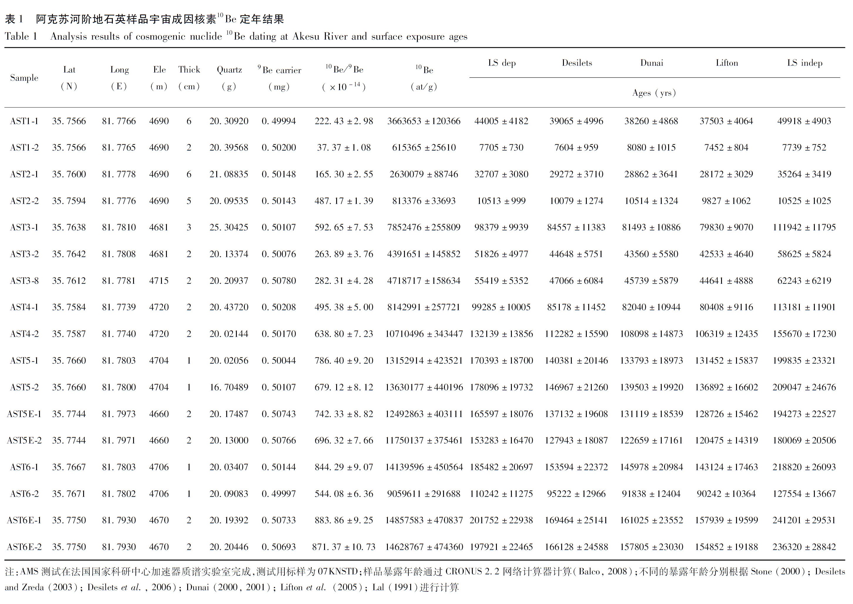
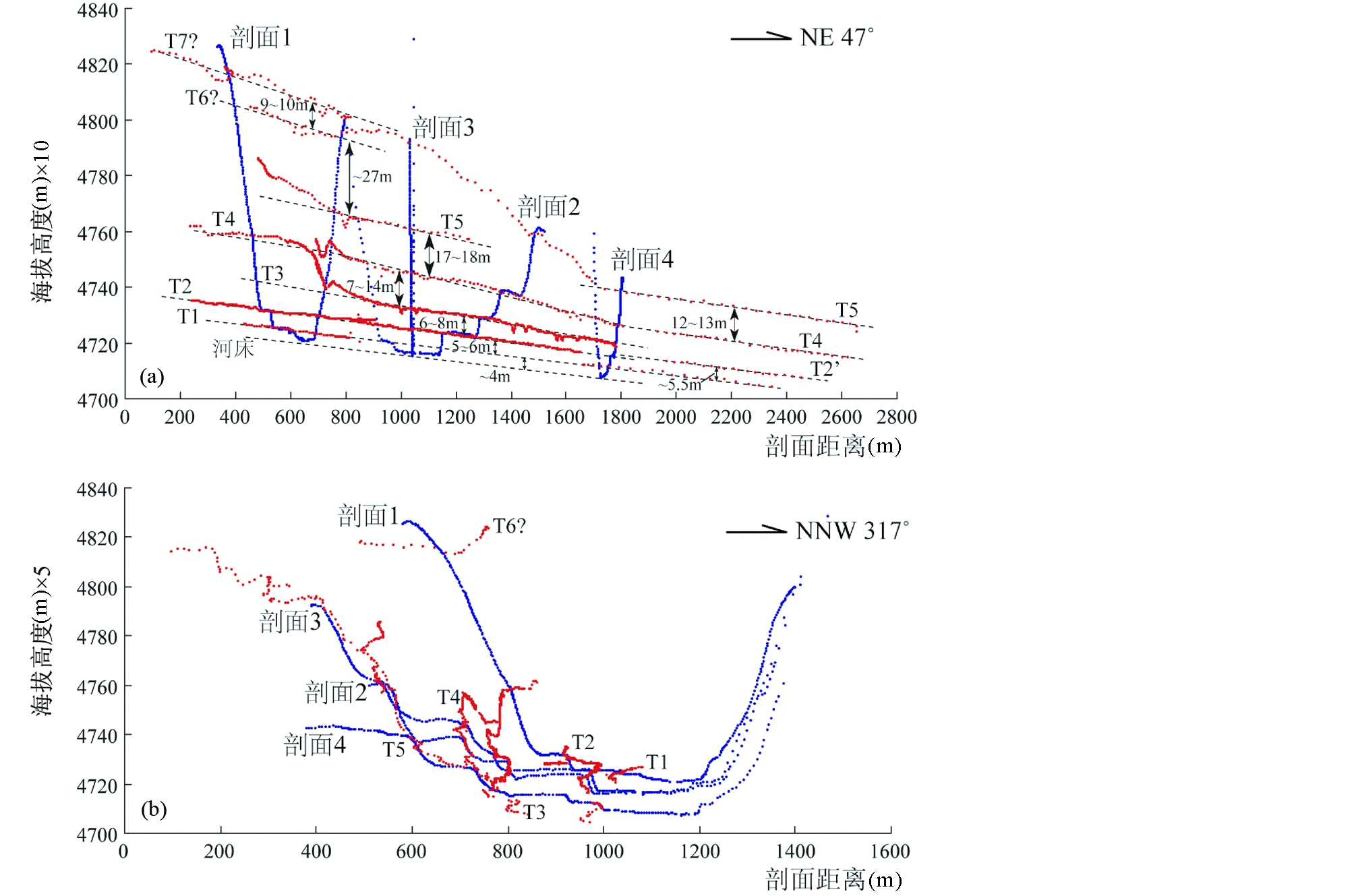
图6 阿克苏河流阶地的野外测量点投影图
(a)-平行于河流总体走向投影;(b)-垂直于河流总体走向投影.图中红色点为野外全站仪测量记录的河流阶地陡坎边缘,蓝色点组成的线为全站仪测量的跨过河流阶地的剖面
Fig.6 Projected survey data of the Akesu river site
(a)-survey data projected parallel to the average flow direction of the Akesu river; (b)-survey data projected perpendicular to the average flow direction of the Akesu river. The red dots are survey points along the river terraces risers and the blue dots are survey data across the river terraces
3 阶地面宇宙成因核素10Be测年结果
为确定阿克苏河各级河流阶地的形成时间,在各级阶地面上均采集了石英样品进行宇宙成因核素10Be暴露年龄测定。在低阶地面上(T1,T2)所采宇宙成因核素样品为半埋藏的单个直径5~10cm的石英砾石,高阶地面上(T3至T7)由于很少见完整的石英砾石,所以样品大多数是直径约2~5cm的石英碎片集合。各样品的分布位置见图3a。
石英样品在进行加速器质谱(AMS)测试前的预处理和提取Be元素的过程参照前人的方法(Gosse and Phillips, 2001; Bierman et al., 2002),在法国斯特拉斯堡地球物理研究所宇宙成因核素10Be/26Al实验室完成,样品的制靶及测试在法国国家科研中心加速器质谱实验室进行。
阿克苏河阶地石英宇宙成因核素10Be年龄测定结果见表1和图7。可以看出,T1级阶地上获得的2个年龄差别较大,分别为44005±4182yrs (AST1-1)和7705±730yrs (AST1-2);T2级阶地上获得的2个年龄差别也较大,分别为32707±3080yrs (AST2-1)和10513±999yrs (AST2-2);T3级阶地上获得的3个年龄中有2个较为接近,分别为51826±4977yrs (AST3-2)和55419±5352yrs (AST3-8),另外1个年龄值较老,为98379±9939yrs (AST3-1);T4级阶地面上的两个年龄分别为99285±10005yrs (AST4-1)和132139±13856yrs (AST4-2);T5级阶地上的4个年龄较为一致,分别为170393±18700yrs (AST5-1)、178096±19732yrs (AST5-2)、165597±18076yrs (AST5E-1)和153283±16470yrs (AST5E-2);T6级阶地上的4个年龄中有3个在误差范围内一致,分别为185482±20697yrs (AST6-1)、201752±22938yrs (AST6E-1)、197921±22465yrs (AST6E-2),另外一个年龄较年轻,为110242±11275yrs (AST6-2)。
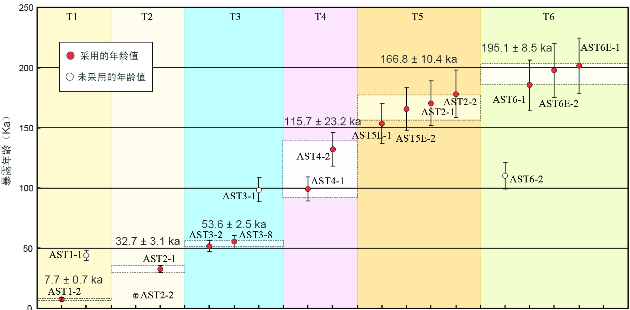
图7 阿克苏河阶地石英样品宇宙成因核素10Be年龄分布图及阶地面时代确定结果
Fig.7 Distribution of cosmogenic nuclide 10Be exposure ages and determined age for each terrace
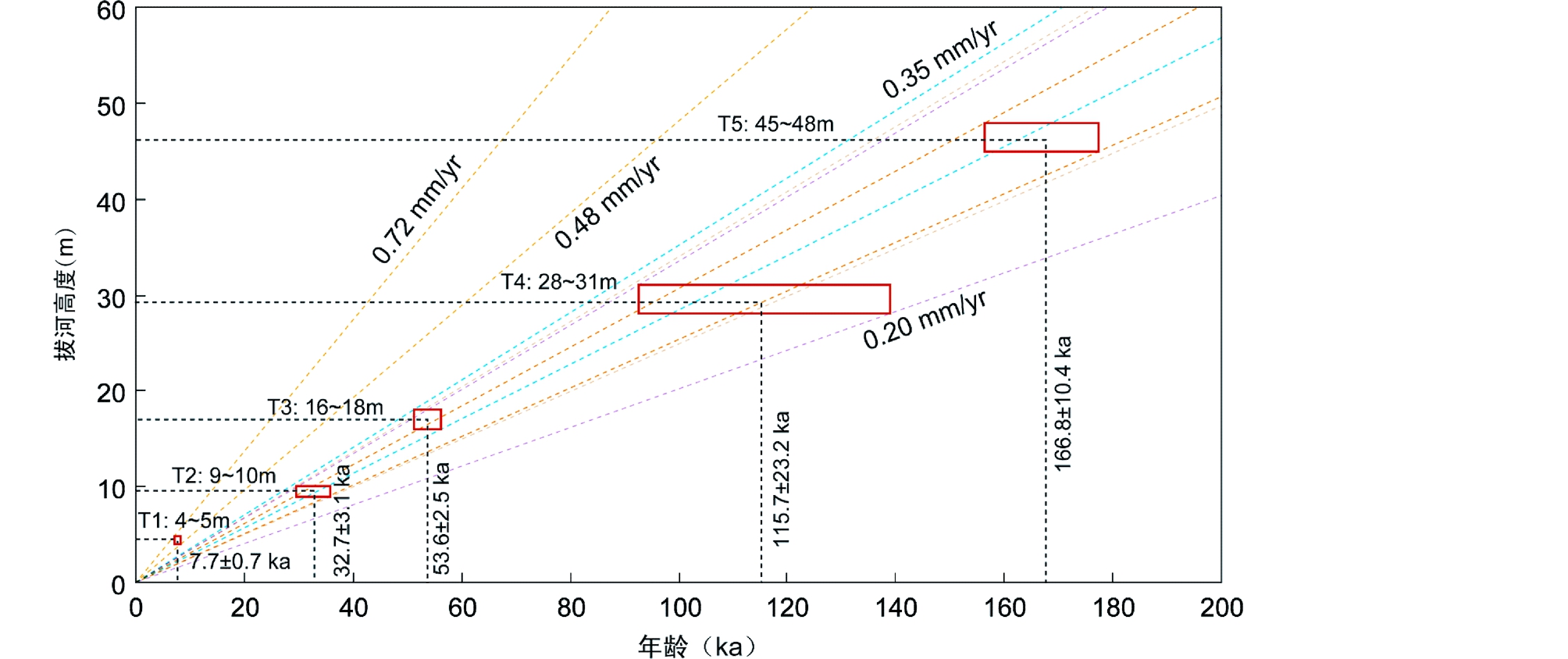
图8 阿克苏河多级河流阶地限定的青藏高原西北部晚第四纪隆升速率
Fig.8 Uplift rates of the northwestern Tibetan Plateau determined from the Akesu river terraces
4 讨论
4.1 各阶地面年龄的确定
虽然我们在阿克苏河各级阶地面上均获得了宇宙成因核素10Be暴露年龄,但由于单个阶地面上的年龄个数不够多(只有2~4个),且在部分阶地面上不同样品的测年结果一致性不是很好,因此有必要将获得的年龄进行横向和纵向的比较和筛选,进而确定了各级阶地面相对合理的年龄值(图7)。
T1级阶地面的2个年龄中AST1-1的年龄(44005±4182yrs)比在T2阶地上获得的2个年龄数据还要大,明显偏老,可能是样品中存在继承性的宇宙核素10Be元素。相对而言,AST1-2的年龄可能更接近真实值,因此取7705±730yrs作为T1阶地的年龄。
从野外测量的数据(图5、图6)来看,T2/T1阶地陡坎的高度与T3/T2阶地陡坎的高度相近,因此在假设河流侵蚀速率恒定的情况下T2阶地的真实年龄应该较为接近T1年龄和T3年龄的平均值,所以我们取AST2-1的年龄(32707±3080yrs)作为T2阶地的年龄,而舍弃AST2-2的较年轻年龄,该年轻年龄可能是由于样品经历过埋藏的原因造成)。
T3阶地面上,AST3-8的年龄明显偏老,该样品采自T4阶地流向T3阶地的一条小冲沟形成的小冲积扇中(图3a),可能是T4阶地面上的石英沿冲沟冲至T3阶地面上,而样品的年龄实际与T4阶地面获得的两个年龄也较为接近。因此我们取AST3-2、AST3-8两个样品年龄的平均值(53623±2541yrs)作为T3阶地的年龄。
T4级阶地面的年龄通过对AST4-1、AST4-2两个样品的年龄平均得到,为115712±23231yrs。
T5级阶地面的年龄通过对4个样品的年龄平均得到,为166842±10403yrs。
T6级阶地面的年龄中,去掉明显偏年轻的样品AST6-2,对其余3个样品年龄求平均,得到的平均年龄为195052±8506yrs。
4.2 青藏高原西北部晚第四纪的隆升
河流阶地是河流发育过程中内因(河流内部动力变化)与外因(构造运动、气候变化、基准面变化)作用下的产物,蕴涵了丰富的构造、气候信息,近年来被广泛应用于构造运动和气候演化历史的研究(Maddy et al., 2000; 潘保田等, 2000, 2007; 王岸等, 2003; Westaway et al., 2006; Demir et al., 2008; Pan et al., 2001, 2009;王永等, 2009; 郑荣章等, 2011)。
由于阶地的形成是河流内因、外因共同作用的结果,除了间歇性的构造运动外,气候变化、侵蚀基准面变化等均可以造成阶地的形成,因此在运用河流阶地进行构造隆升作用研究时,有诸多问题需要考虑。一般来说,在河流的中下游段,特别是山前地形高差较大的河段,气候及侵蚀基准面变化对河流的影响较大,阶地的形成可能是气候与构造以及其他因素共同作用的结果,而我们本次研究的阿克苏河多级阶地位于青藏高原内部,接近河流源头处,周围地形平坦,高差较小,受气候及其他因素影响相对较小,阶地的形成应该主要是构造隆升造成的结果。
根据河流阶地的形成过程和驱动机制的不同,可以将阶地划分宽谷阶地(strath terrace) 、堆积阶地(fill terrace) 以及堆积-切割阶地(fill-cut terrace) 3种不同类型(Bull, 1991)。一般认为,宽谷阶地是构造成因阶地,蕴涵了流域内构造抬升的历史信息,堆积阶地则是气候成因阶地,而堆积-切割阶地则是构造、气候等共同作用的复杂响应阶地(Ouchi, 1985; Bull, 1991; Merritts et al., 1994)。本次研究的阿克苏河流阶地,虽然表面上看,低阶地主要被砾石、沙土、黄土或火山岩碎屑覆盖(图3b,c),但在高阶地面上明显可以看到研究区广泛分布的火山熔岩基岩(图3e, f)。在研究点北东端T5/T0阶地陡坎上可以看到连续分布的层状火山岩基岩(图3f),再向东,河谷变窄处可见河流直接深切火山岩基岩,各级阶地均发育在火山岩基岩上(图3g)。这表明阿克苏河发育的多级阶地整体是以阿什库勒盆地内广泛分布的第四纪火山岩为基座的,是典型的构造成因的宽谷阶地,而各阶地面上覆盖的薄层沉积物则为我们确定阶地面年龄提供了良好的材料。
根据我们野外测量获得的各级河流阶地的拔河高度和宇宙成因核素10Be测年得到的各级阶地的暴露年龄,我们对阿克苏河晚第四纪不同时间至今的河流下切速率进行了计算(图8),结果显示,阿克苏河晚第四纪166.8ka以来的下切速率总体介于0.2~0.35mm/yr之间,其中最新的T1阶地计算的7.7ka以来的河流下切速率为0.48~0.72mm/yr,显示在这一时期内青藏高原西北部的构造抬升可能进一步加强。在气候变化和侵蚀基准面变化等其他因素可以忽略的情况下,可以推测,青藏高原西北部西昆仑地区晚第四纪166.8ka以来的平均隆升速率也在0.2~0.35mm/yr之间,最大不超过0.72mm/yr。
5 结论
在青藏高原西北部阿什库勒地区,阿克苏河两岸发育高原内部十分罕见的多达7级的河流阶地。通过对该处河流阶地结构、沉积特征、几何特征的研究,确定该阶地是典型的构造成因阶地。利用宇宙成因核素10Be测年方法对各级阶地面的暴露年龄进行了测定,结合野外全站仪测量得到的各级阶地的拔河高度,确定了阿克苏河晚第四纪166.8ka以来的河流下切速率为0.2~0.35mm/yr,该速率代表了青藏高原西北部晚第四纪166.8ka以来的隆升速率。
致谢 宇宙成因核素10Be测年在法国斯特拉斯堡地球物理研究所Jerome Van Der Woerd教授的指导下进行,吴富峣、邱祝礼参加了部分野外工作。感谢审稿人对本文提出的宝贵意见。
References
Arnaud NO, Brunel M, Cantagrel JM and Tapponnier P. 1993. High cooling and denudation rates at Kongur Shan, Eastern Pamir (Xinjiang, China) revealed by 40Ar/39Ar alkali feldspar thermochronology. Tectonics, 12(6): 1335-1346
Balco G, Stone JO, Lifton NA and Dunai TJ. 2008. A complete and easily accessible means of calculating surface exposure ages or erosion rates from 10Be and 26Al measurements. Quaternary Geochronology, 3(3): 174-195
Bierman PR, Caffee MW, Davis PT, Marsella K, Pavich M, Colgan P, Mickelson D and Larsen J. 2002. Rates and timing of Earth surface processes from in situ-produced cosmogenic Be-10. Reviews in Mineralogy and Geochemistry, 50(1): 147-205
Bull WB. 1991. Geomorphic Responses to Climate Change. New York: Oxford University Press, 1-326
Cao K, Wang GC, Liu C and Meng YN. 2009. Thermochronological evidence of the Cenozoic differential uplift processes of the West Kunlun and its adjacent area. Earth Science, 34(6): 895-906 (in Chinese with English abstract)
Cao K, Bernet M, Wang GC, van der Beek P, Wang A, Zhang KX and Enkelmann E. 2013a. Focused Pliocene-Quaternary exhumation of the Eastern Pamir domes, western China. Earth and Planetary Science Letters, 363: 16-26
Cao K, Wang GC, van der Beek P, Bernet M and Zhang KX. 2013b. Cenozoic thermo-tectonic evolution of the northeastern Pamir revealed by zircon and apatite fission-track thermochronology. Tectonophysics, 589: 17-32
Cowgill E. 2010. Cenozoic right-slip faulting along the eastern margin of the Pamir salient, northwestern China. Geological Society of America Bulletin, 122(1-2): 145-161
Demir T, Seyrek A, Westaway R, Bridgland D and Beck A. 2008. Late Cenozoic surface uplift revealed by incision by the River Euphrates at Birecik, Southeast Turkey. Quaternary International, 186(1): 132-163
Deng WM. 1989. Geological investigation on the volcanic group in the Wulukekule (lake) region, Xinjiang: Query the validity of “the eruption of No. 1 volcano in 1951”. Journal of Natural Resources, 4(4): 349-354 (in Chinese with English abstract)
Desilets D and Zreda M. 2003. Spatial and temporal distribution of secondary cosmic-ray nucleon intensities and applications to in situ cosmogenic dating. Earth and Planetary Science Letters, 206(1): 21-42
Desilets D, Zreda M and Prabu T. 2006. Extended scaling factors for in situ cosmogenic nuclides: New measurements at low latitude. Earth and Planetary Science Letters, 246(3-4): 265-276
Dunai TJ. 2000. Scaling factors for production rates of in situ produced cosmogenic nuclides: A critical reevaluation. Earth and Planetary Science Letters, 176(1): 157-169
Dunai TJ. 2001. Influence of secular variation of the geomagnetic field on production rates of in situ produced cosmogenic nuclides. Earth and Planetary Science Letters, 193(1): 197-212
Gosse JC and Phillips FM. 2001. Terrestrial in situ cosmogenic nuclides: Theory and application. Quaternary Science Reviews, 20(14): 1475-1560
Jin XC, Wang J, Chen BW and Ren LD. 2001. Stratigraphic and sedimentologic records of the uplifting of the West Kunlun in the Cenozoic. Acta Geologica Sinica, 75(4): 459-467 (in Chinese with English abstract)
Jin XC, Wang J, Chen BW and Ren LD. 2003. Cenozoic depositional sequences in the piedmont of the West Kunlun and their paleogeographic and tectonic implications. Journal of Asian Earth Sciences, 21(7): 755-765
Lal D. 1991. Cosmic ray labeling of erosion surfaces: In situ nuclide production rates and erosion models. Earth and Planetary Science Letters, 104(2-4): 424-439
Li DP, Zhao Y, Hu JM, Wan JL, Li XL, Zhou XK, Du SX, Pan YB and Pei JL. 2007. Fission track thermochronologic constraints on plateau surface and geomorphic relief formation in the northwestern margin of the Tibetan Plateau. Acta Petrologica Sinica, 23(5): 900-910 (in Chinese with English abstract)
Li DP, Zhao Y, Liu J, Wan JL, Zheng DW, Pan YB and He ZF. 2010. Ages and causes of steep slope relief between Tarim Basin and northwestern margin of the Tibetan Plateau: The evidence from apatite fission track dating of north margin of West Kunlun Mountains. Chinese Journal of Geology, 45(4): 930-943 (in Chinese with English abstract)
Li HB, Yang JS, Xu ZQ and Sun ZM. 2006. The constraint of the Altyn Tagh fault system to the growth and rise of the northern Tibetan Plateau. Earth Science Frontiers, 13(4): 59-79 (in Chinese with English abstract)
Li HB, Tapponnier P, Klinger Y, Lacassin R, Pei JL, Qiu ZL, Pan JW and Si JL. 2009. Field study of the 20/03/2008, MW 7.2 Ashikule earthquake rupture (Xinjiang, China). EOS Trans. Association of Global Universities, 90(52), Fall Meet. Suppl., abstract GP21A-0770
Li XC, Wang Y and Ding XZ. 2005. The age of Late Cenozoic molasse in the front of the western Kunlun, Xinjiang and its significance. Journal of Geomechanics, 11(2): 181-186 (in Chinese with English abstract)
Lifton NA, Bieber JW, Clem JM, Duldig ML, Evenson P, Humble JE and Pyle R. 2005. Addressing solar modulation and long-term uncertainties in scaling secondary cosmic rays for in situ cosmogenic nuclide applications. Earth and Planetary Science Letters, 239(1-2): 140-161
Liu DL, Li HB, Pan JW, Chevalier ML, Pei JL, Sun ZM, Si JL and Xu W. 2011. Morphotectonic study from the northeastern margin of the Pamir to the West Kunlun range and its tectonic implications. Acta Petrologica Sinica, 27(11): 3499-3512 (in Chinese with English abstract)
Liu JQ and Yiming M. 1990. The distribution of Quaternary volcanics and its K-Ar isotopic age in western Kunlun Mts. Science in China (Series D), 20(2): 180-187 (in Chinese)
Liu X, Wang J, Zhang ZC and Wang Y. 2002. Relation between the components of Quaternary molasse and uplift of the Qinghai-Tibet Plateau: Preliminary understanding of the results of measurements of the Quaternary pebble composition at the Kokyar section, Yecheng, Xinjiang. Geological Bulletin of China, 21(11): 759-763 (in Chinese with English abstract)
Maddy D, Bridgland DR and Green CP. 2000. Crustal uplift in southern England: Evidence from the river terrace records. Geomorphology, 33(3-4): 167-181
Merritts DJ, Vincent KR and Wohl EE. 1994. Long river profiles, tectonism, and eustasy: A guide to interpreting fluvial terraces. Journal of Geophysical Research, 99(B7): 14031-14050
Molnar P and Tapponnier P. 1975. Cenozoic tectonics of Asia: Effects of a continental collision. Science, 189(4201): 418-426
Molnar P, England P and Martinod J. 1993. Mantle dynamics, uplift of the Tibetan Plateau, and the Indian monsoon. Reviews of Geophysics, 31(4): 357-396
Ouchi S. 1985. Response of alluvial rivers to slow active tectonic movement. Geological Society of America Bulletin, 96(4): 504-515
Pan BT, Wu GJ, Wang YX, Liu ZG and Guan QY. 2001. Age and genesis of the Shagou River terraces in eastern Qilian Mountains. Chinese Science Bulletin, 46(6): 509-513
Pan BT, Su H, Liu XF, Hu XF, Zhou T, Hu CS and Li JJ. 2007. River terraces of the Yellow River and their genesis in eastern Lanzhou basin during last 1.2Ma. Quaternary Sciences, 27(2): 172-180 (in Chinese with English abstract)
Pan BT, Su H, Hu ZB, Hu XF, Gao HS, Li JJ and Kirby E. 2009. Evaluating the role of climate and tectonics during non-steady incision of the Yellow River: Evidence from a 1.24Ma terrace record near Lanzhou, China. Quaternary Science Reviews, 28(27-28): 3281-3290
Pan JW, Li HB, Van Der Woerd J, Sun ZM, Pei JL, Barrier L and Si JL. 2007. Late Cenozoic morphotectonic features of the thrust belt in the front of the West Kunlun Mountains. Geological Bulletin of China, 26(10): 1368-1379 (in Chinese with English abstract)
Pan JW, Li HB, Van Der Woerd J, Sun ZM, Pei JL, Si JL and Qiu ZL. 2009. Tectonic geomorphology and active tectonics in north eastern Pamir, northwest margin of Qinghai-Tibet Plateau. Quaternary Sciences, 29(3): 586-598 (in Chinese with English abstract)
Royden LH, Burchfiel BC and van der Hilst RD. 2008. The geological evolution of the Tibetan Plateau. Science, 321(5892): 1054-1058
Si JL, Li HB, Barrier L, Van Der Woerd J, Sun ZM, Pei JL and Pan JW. 2007. Late Cenozoic uplift of the northwestern margin of the Qinghai-Tibet Plateau: Sedimentary evidence from piedmont basins of the West Kunlun Mountains. Geological Bulletin of China, 26(10): 1356-1367 (in Chinese with English abstract)
Sobel ER, Schoenbohm LM, Chen J, Thiede R, Stockli DF, Sudo M and Strecker MR. 2011. Late Miocene-Pliocene deceleration of dextral slip between Pamir and Tarim: Implications for Pamir orogenesis. Earth and Planetary Science Letters, 304(3-4): 369-378
Sobel ER, Chen J, Schoenbohm LM, Thiede R, Stockli DF, Sudo M and Strecker MR. 2013. Oceanic-style subduction controls Late Cenozoic deformation of the northern Pamir orogen. Earth and Planetary Science Letters, 363: 204-218
Stone JO. 2000. Air pressure and cosmogenic isotope production. Journal of Geophysical Research, 105(B10): 23753-23759
Tapponnier P and Molnar P. 1976. Slip-line field theory and large-scale continental tectonics. Nature, 264(5584): 319-324
Tapponnier P, Peltzer G and Armijo R. 1986. On the mechanics of the collision between India and Asia. Geological Society, London, Special Publications, 19(1): 113-157
Tapponnier P, Xu ZQ, Roger F, Meyer B, Arnaud N, Wittlinger G and Yang JS. 2001. Oblique stepwise rise and growth of the Tibet Plateau. Science, 294(5547): 1671-1677
Wan JL and Wang EQ. 2002. FT evidence of West Kunlun uplift in Pulu. Nuclear Techniques, 25(7): 565-567 (in Chinese with English abstract)
Wang A, Wang GC and Xiang SY. 2003. Characteristics of river terraces in north slope of eastern Kunlun Mountains and their relationship with plateau uplift. Earth Science, 28(6): 675-679 (in Chinese with English abstract)
Wang E, Wan JL and Liu JQ. 2003. Late Cenozoic geological evolution of the foreland basin bordering the West Kunlun range in Pulu area: Constraints on timing of uplift of northern margin of the Tibetan Plateau. Journal of Geophysical Research, 108(B8): 2401
Wang J. 1998. Uplift of the Karibasheng and Kuzigan granite in the West Kunlun Mountains: Evidence from apatite fission track analysis. Geological Review, 44(4): 435-442 (in Chinese with English abstract)
Wang Y, Wang YB, Liu X, Xiao XC, Wang J and Zhang JC. 2002. Apatite fission-track ages of Late Cenozioc sediments from Kokyar section in western Kunlun foreland basin and their significance. Xinjiang Geology, 20(S1): 43-46 (in Chinese with English abstract)
Wang Y, Wang J, Xiao XC, Chi ZQ and Wang YB. 2009. Piedmont river terraces formation of the western Kunlun, China and their tectonic significance. Geological Bulletin of China, 28(12): 1779-1785 (in Chinese with English abstract)
Wang YB, Wang Y, Liu X, Fu DR, Wang J and Wang SC. 2001. Apatite fission-track records of Mesozoic and Cenozoic episodic reactivation of the Tianshan and West Kunlun Mountains. Regional Geology of China, 20(1): 94-99 (in Chinese with English abstract)
Westaway R, Bridgland D and White M. 2006. The Quaternary uplift history of central southern England: Evidence from the terraces of the Solent River system and nearby raised beaches. Quaternary Science Reviews, 25(17-18): 2212-2250
Xu XW, Tan XB, Yu GH, Wu GD, Fang W, Chen JB, Song HP and Shen J. 2013. Normal- and oblique-slip of the 2008 Yutian earthquake: Evidence for eastward block motion, northern Tibetan Plateau. Tectonophysics, 584: 152-165
Xu ZQ, Yang JS, Li HB, Zhang JX and Wu CL. 2007. Orogenic Plateau: Terrain Tectonics, Collisional Orogenesis, and Uplift Mechanisms. Beijing: Geological Publication House, 1-458 (in Chinese)
Yin A and Harrison TM. 2000. Geologic evolution of the Himalayan-Tibetan orogen. Annual Review of Earth and Planetary Sciences, 28(1): 211-280
Zheng HB, Powell CM, An ZS, Zhou J and Dong GR. 2000. Pliocene uplift of the northern Tibetan Plateau. Geology, 28(8): 715-718
Zheng HB, Butcher K and Powell C. 2002. Evolution of Neogene foreland basin in Yecheng, Xinjiang, and uplift of northern Tibetan Plateau-I Stratigraphy and petrology. Acta Sedimentologica Sinica, 20(2): 274-281 (in Chinese with English abstract)
Zheng HB, Powell CA, Butcher K and Cao JJ. 2003. Late Neogene loess deposition in southern Tarim Basin: Tectonic and palaeoenvironmental implications. Tectonophysics, 375(1-4): 49-59
Zheng HB, Butcher K and Powell C. 2003. Evolution of Neogene foreland basin in Yecheng, Xinjiang, and uplift of northern Tibetan Plateau-Ⅱ Facies analysis. Acta Sedimentologica Sinica, 21(1): 46-51 (in Chinese with English abstract)
Zheng HB, Huang XT and Butcher K. 2006. Lithostratigraphy, petrography and facies analysis of the Late Cenozoic sediments in the foreland basin of the West Kunlun. Palaeogeography, Palaeoclimatology, Palaeoecology, 241(1): 61-78
Zheng RZ, Xu XW, Ma WT and Li JP. 2011. Tectonic and climatic signification of terraces at the outlet of Moleqiehe river, the western segment of Altyn Tagh fault zone. Seismology and Geology, 33(2): 323-334(in Chinese with English abstract)
附中文参考文献
曹凯, 王国灿, 刘超, 孟艳宁. 2009. 西昆仑及邻区新生代差异隆升的热年代学证据. 地球科学, 34(6): 895-906
邓万明. 1989. 新疆乌鲁克库勒火山群地质考察——“1951年1号火山喷发”质疑. 自然资源学报, 4(4): 349-354
金小赤, 王军, 陈炳蔚, 任留东. 2001. 新生代西昆仑隆升的地层学和沉积学记录. 地质学报, 75(4): 459-467
黎敦朋, 赵越, 胡建民, 万景林, 李新林, 周小康, 杜少喜, 潘燕兵, 裴军令. 2007. 青藏高原西北缘高原面与陡坡地貌形成过程的裂变径迹热年代学约束. 岩石学报, 23(5): 900-910
黎敦朋, 赵越, 刘健, 万景林, 郑德文, 潘燕兵, 何哲峰. 2010. 青藏高原西北缘盆山过渡带陡坡地貌的形成时代与成因——来自西昆仑山北缘裂变径迹分析的证据. 地质科学, 45(4): 930-943
李海兵, 杨经绥, 许志琴, 孙知明. 2006. 阿尔金断裂带对青藏高原北部生长、隆升的制约. 地学前缘, 13(4): 59-79
李喜臣, 王永, 丁孝忠. 2005. 西昆仑山前晚新生代磨拉石时代及意义. 地质力学学报, 11(2): 181-186
刘栋梁, 李海兵, 潘家伟, Chevalier ML, 裴军令, 孙知明, 司家亮, 许伟. 2011. 帕米尔东北缘-西昆仑的构造地貌及其构造意义. 岩石学报, 27(11): 3499-3512
刘嘉麒, 买买提依明. 1990. 西昆仑山第四纪火山的分布与K-Ar年龄. 中国科学(B辑), 20(2): 180-187
刘训, 王军, 张招崇, 王永. 2002. 第四纪磨拉石组分与青藏高原隆升的关系——对新疆叶城柯克亚剖面第四系砾石成分测量结果的认识. 地质通报, 21(11): 759-763
潘保田, 邬光剑, 王义祥, 刘志刚, 管清玉. 2000. 祁连山东段沙沟河阶地的年代与成因. 科学通报, 45(24): 2669-2675
潘保田, 苏怀, 刘小丰, 胡小飞, 周天, 胡春生, 李吉均. 2007. 兰州东盆地最近1.2Ma的黄河阶地序列与形成原因. 第四纪研究, 27(2): 172-180
潘家伟, 李海兵, Van Der Woerd J, 孙知明, 裴军令, Barrier L, 司家亮. 2007. 西昆仑山前冲断带晚新生代构造地貌特征. 地质通报, 26(10): 1368-1379
潘家伟, 李海兵, Van Der Woerd J, 孙知明, 裴军令, 司家亮, 邱祝礼. 2009. 青藏高原西北部帕米尔东北缘构造地貌与活动构造研究. 第四纪研究, 29(3): 586-598
司家亮, 李海兵, Barrier L, Van Der Woerd J, 孙知明, 裴军令, 潘家伟. 2007. 青藏高原西北缘晚新生代的隆升特征——来自西昆仑山前盆地的沉积学证据. 地质通报, 26(10): 1356-1367
万景林, 王二七. 2002. 西昆仑北部山前普鲁地区山体抬升的裂变径迹研究. 核技术, 25(7): 565-567
王岸, 王国灿, 向树元. 2003. 东昆仑山东段北坡河流阶地发育及其与构造隆升的关系. 地球科学, 28(6): 675-679
王军. 1998. 西昆仑卡日巴生岩体和苦子干岩体的隆升——来自磷灰石裂变径迹分析的证据. 地质评论, 44(4): 435-442
王彦斌, 王永, 刘训, 傅德荣, 王军, 王世成. 2001. 天山、西昆仑山中、新生代幕式活动的磷灰石裂变径迹记录. 中国区域地质, 20(1): 94-99
王永, 王彦斌, 刘训, 肖序常, 王军, 张招崇. 2002. 柯克亚剖面新生代晚期沉积物中磷灰石裂变径迹年龄及意义. 新疆地质, 20(S1): 43-46
王永, 王军, 肖序常, 迟振卿, 王彦斌. 2009. 西昆仑山前河流阶地的形成及其构造意义. 地质通报, 28(12): 1779-1785
许志琴, 杨经绥, 李海兵, 张建新, 吴才来. 2007. 造山的高原——青藏高原的地体拼合、碰撞造山及隆升机制. 北京: 地质出版社, 1-458
郑洪波, Butcher K, Powell C. 2002. 新疆叶城晚新生代山前盆地演化与青藏高原北缘的隆升-I. 地层学与岩石学证据. 沉积学报, 20(2): 274-281
郑洪波, Butcher K, Powell C. 2003. 新疆叶城晚新生代山前盆地演化与青藏高原北缘的隆升-II. 沉积相与沉积盆地演化. 沉积学报, 21(1): 46-51
郑荣章, 徐锡伟, 马文涛, 李建平. 2011. 阿尔金断裂带西段莫勒切河河口阶地的构造及气候意义. 地震地质, 33(2): 323-334
Abstract Uplift of the Qinghai-Tibet Plateau is the most spectacular Cenozoic geological event. Study on the uplift of the Qinghai-Tibet Plateau has been the focus of geologists. River terraces record a wealth of information about tectonic movement and climate change, and have been widely applied in tectonic movement and climate change study in recent years. However, previously studied river terraces basically distributed in the periphery of the Tibetan Plateau, thus the formation of the terraces may be the results from combination of climate change and tectonic uplift. By interpretation of high-resolution satellite images, we found as many as 7 river terraces in the Ashikule basin, West Kunlun Mountain, which lies in the interior of the Qinghai-Tibet Plateau. Study on the structure, sedimentary characteristics, and geometric characteristics of these terraces shows that the terraces here are typical tectonic origin. Geomorphology and topography of the terraces was surveyed with a total station in the field. Survey data show the heights of the terraces are 4~5m (T1), 9~10m (T2), 16~18m (T3), 28~31m (T4), and 45~48m (T5) respectively. Exposure ages of the terraces were determined by cosmogenic nuclide 10Be dating methods, which are 7.7±0.7ka (T1), 32.7±3.1ka (T2), 53.6±2.5ka (T3), 115.7±23.2ka (T4), 166.8±10.4ka (T5), and 19.5±8.5ka (T6). Combine the heights and ages of the terraces, river incision rates since 166.8ka to now are determined as 0.2~0.35mm/yr. The incision rate of 0.2~0.35mm/yr represents the average uplift rate in the northwestern Tibetan Plateau since 166.8ka.
Key words Tibetan Plateau; Uplift; Late Quaternary; River terrace; Cosmogenic Nuclide Dating
*本文受受国家自然科学基金项目(41202156、41221061)、中国地质调查局地质大调查项目(1212011121267)、行业基金项目(201011034)和中国地质科学院地质研究所基本科研业务经费项目(J1215)联合资助.
**通讯作者:李海兵,男,1966年生,博士,研究员,从事青藏高原构造地质研究,E-mail: lihaibing06@163.com
中图法分类号 P534.63; P542.1
2013-02-11 收稿, 2013-05-14 改回.
Pan JW, Li HB, Sun ZM, Si JL, Pei JL, Liu DL and Chevalier ML. 2013. Late Quaternary uplift of the northwestern Tibetan Plateau: Evidences from river terraces in the Ashikule area, West Kunlun Mountain. Acta Petrologica Sinica, 29(6):2199-2210