赣北第四纪红壤区侵蚀性降雨强度与雨量标准的确定
【类型】期刊
【作者】汪邦稳,方少文,宋月君,杨洁(江西省水土保持科学研究院江西省土壤侵蚀与防治重点实验室)
【作者单位】江西省水土保持科学研究院江西省土壤侵蚀与防治重点实验室
【刊名】农业工程学报
【关键词】 径流;泥沙;侵蚀;侵蚀性降雨标准;水土保持;第四纪红壤区
【资助项】国家自然科学基金(41201276);水利部公益性行业科研专项经费项目(201301050)
【ISSN号】1002-6819
【页码】P100-106
【年份】2019
【期号】第11期
【期刊卷】1;|6;|7;|8;|4;|5;|2
【摘要】降雨是土壤侵蚀的主要动力因子,侵蚀性降雨标准的获取是计算降雨侵蚀力的重要环节;目前,红壤区侵蚀性降雨标准不一致,需要进一步研究。利用2001—2009年的1359场降雨数据,对赣北第四纪红壤区不同下垫面的侵蚀性降雨标准进行研究,得出结论如下:1)不同下垫面满足拟定侵蚀性降雨标准的数据序列长度存在明显差异,满足拟定侵蚀性降雨标准的数据序列长度可以反映水土保持措施从实施到发挥稳定效益所需的年限;2)具有水土保持措施的下垫面能够有效提高侵蚀性雨量标准,柑橘+前埂后沟梯壁植草水平梯田的第5小区侵蚀性雨量标准为16.2mm,比地表裸露小区的11.4mm提高42.1%;3)对于没有水土保持措施或稳定性高的水土保持措施下垫面,宜采用时段侵蚀性雨强标准;对于稳定性低的水土保持措施下垫面,宜采用侵蚀性雨量标准。该研究为区域水土保持规划提供参考。
【全文】 文献传递
赣北第四纪红壤区侵蚀性降雨强度与雨量标准的确定
摘 要:降雨是土壤侵蚀的主要动力因子,侵蚀性降雨标准的获取是计算降雨侵蚀力的重要环节;目前,红壤区侵蚀性降雨标准不一致,需要进一步研究。利用2001—2009年的1359场降雨数据,对赣北第四纪红壤区不同下垫面的侵蚀性降雨标准进行研究,得出结论如下:1)不同下垫面满足拟定侵蚀性降雨标准的数据序列长度存在明显差异,满足拟定侵蚀性降雨标准的数据序列长度可以反映水土保持措施从实施到发挥稳定效益所需的年限;2)具有水土保持措施的下垫面能够有效提高侵蚀性雨量标准,柑橘+前埂后沟梯壁植草水平梯田的第5小区侵蚀性雨量标准为16.2 mm,比地表裸露小区的11.4 mm提高42.1%;3)对于没有水土保持措施或稳定性高的水土保持措施下垫面,宜采用时段侵蚀性雨强标准;对于稳定性低的水土保持措施下垫面,宜采用侵蚀性雨量标准。该研究为区域水土保持规划提供参考。
关键词:径流,泥沙,侵蚀,侵蚀性降雨标准,水土保持,第四纪红壤区
0 引言
土壤侵蚀因子中,降雨是主要的动力因子,降雨侵蚀力的计算是定量预报土壤侵蚀的重要环节[1-4]。但是,在所有的降雨事件中,并非每个降雨事件都能引起土壤侵蚀,所以将发生侵蚀和不发生侵蚀的临界降雨数值,作为侵蚀性降雨标准[5-7]。同样的降雨,不同的下垫面其侵蚀性降雨标准不同;侵蚀性降雨标准的研究,可以减少降雨侵蚀力计算工作量,提高获取结果的精度[8]。就某一地区某一确定的下垫面而言,侵蚀性降雨标准是客观存在的,但由于计算方法和选用的数据序列不同,获取的侵蚀性降雨标准可能不同。目前,红壤区侵蚀性降雨标准是采用短序列数据获取的,不同的研究方法得出的结论相差较大[9-11],所以该地区的侵蚀性降雨标准有待进一步的研究。
柑橘是赣北主要的经果林,是江西名优特产品之一,2010年江西种植面积约30万hm2[12];但水土流失和季节性干旱给柑橘的产量带来严重的影响。利用水土保持措施与柑橘种植相结合可以为解决柑橘园水土流失和季节性干旱提供新的途径[13],因此,本研究分别选择常用的水土保持耕作措施、植物措施与工程措施与柑橘种植相互配置,以地表裸露坡地和柑橘净耕为对照,基于能量的角度[14-15],利用2001—2009年9 a的1359场降雨数据,分析赣北第四纪红壤区不同水土保持措施与柑橘种植相配置的下垫面侵蚀性雨量标准和时段雨强标准,以期揭示实施水土保持措施红壤坡地的减水减沙机理,为提高该地区的水土流失预报精度提供数据基础,为区域水土保持规划提供参考。
1 材料与方法
1.1 研究区概况
试验区布设在江西水土保持生态科技园(115°42′38″-115°43′06″E,29°16′37″-29°17′40″N),面积80 hm2,属亚热带季风区,气候温和,四季分明,雨量充沛,光照充足,且雨热基本同期。多年平均降雨量为 1469 mm,最大年降雨量为1 808.5 mm,最小年降雨量为865.6 mm[16]。科技园区位于中国红壤的中心区域,属全国土壤侵蚀二级类型区的南方红壤区,土壤为第四纪红壤,土层平均厚度11 m,土壤pH值5.0,有机质含量1.55%,总氮0.08%,总磷0.07%,总钾1.7%,C/N值7.5[17]。江西第四纪红壤位于海拔30~80 m的丘陵或滨湖平原地带,地势平缓,土层厚度3~40 m,面积为4 422.9 km2,是江西省经济作物及粮食生产的重要基地。科技园地貌类型为浅丘岗地,海拔高度30~100 m,坡度5°~25°;地带性植被类型为常绿阔叶林,植物种类繁多,植被类型复杂多样,但由于长期不合理的采伐利用,造成地表植被遭到破坏,现存植被多为人工营造的针叶林、常绿阔叶林、竹林、针阔混交林、落叶阔叶林等。建园初期生态环境脆弱,水土流失十分严重,水土流失面积达72.0 hm2,占土地总面积的 85.7%,年土壤侵蚀总量为2 122.6 t,土壤侵蚀模数为 2 948 t/(km2·a),土壤侵蚀类型以水力侵蚀为主。
1.2 研究方法
在土层厚度均匀、土壤理化特性较一致、坡度较均一的坡面,布设5个20 m× 5 m径流试验小区,编号为1~5,坡度均为12°。为阻止地表径流进出,在试验小区周边设置围埂,其埂高出地表 0.3 m,埋深0.45 m,用混凝土砖块砌成。小区下面修筑横向集水槽,承接小区径流及泥沙,并引入径流池。径流池根据当地可能发生的最大暴雨设计成A、B、C 3池,每池均按按1.0m×1.2m×1.0m方形构筑。A、B 2池均装有有五分法60°“V”型三角分流堰,其中A池4份排出,内侧1份流入B池,B池与A池一样,其中一份进入C池。每个池子都进行了率定,池壁均安装有搪瓷水尺。具体措施及配置见图1。柑橘清耕措施、柑橘+横坡耕作措施是赣北柑橘种植较为常见的措施,柑橘+前埂后沟梯壁植草水平梯田措施(图2)是坡耕地综合整治的主要治理方式。
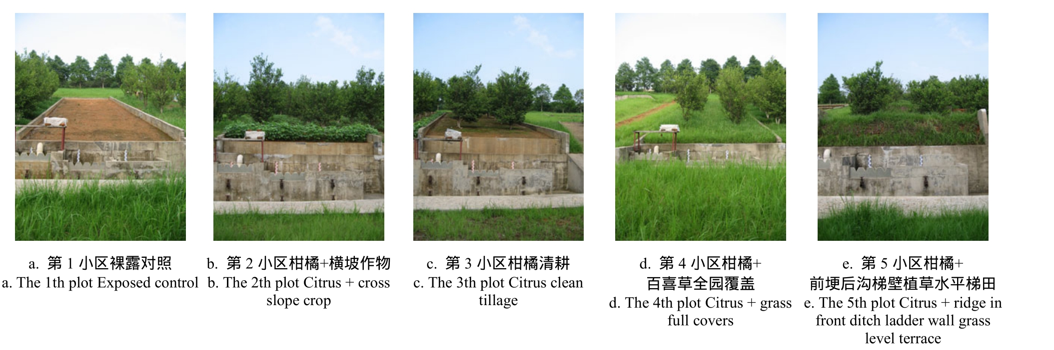
图1 径流小区
Fig.1 Basic situation of runoff plots
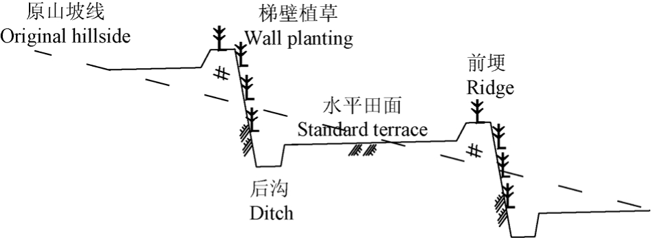
图2 前埂后沟梯壁植草水平梯田示意图
Fig.2 Ridge in front ditch ladder wall grass level terrace
除对照区外,每个小区种有柑橘 12株,由上至下6行,行距3.0 m,每行2株,株距2.5m。耕作小区在每年4月中旬到8月中旬套种黄豆,8月中旬到次年3月中旬套种萝卜;前埂后沟梯田小区设3个台面,梯角75°,梯区平面6×5 m2。其中,埂高0.3 m,顶宽0.3 m,排水沟位于梯面内侧,沟深0.3 m,宽0.2 m;各小区的土壤颗粒组成和土壤质地,见表 1。试验小区管理方法均按《水土保持试验规程SL419-2007》进行。
表1 各小区土壤颗粒组成及土壤质地
Table 1 Composition of the soil particles and soil texture for runoff plots
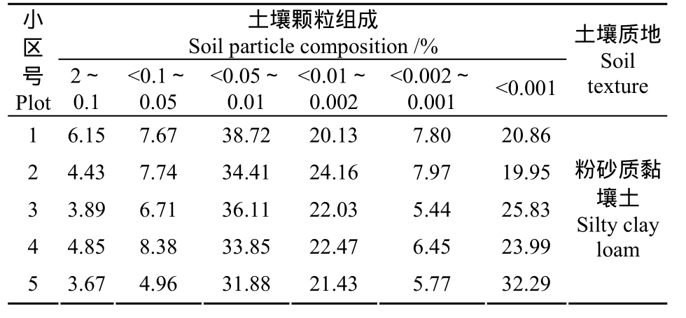
土壤颗粒组成Soil particle composition /%小区号Plot 2~0.1<0.1~0.05<0.05~0.01<0.01~0.002<0.002~0.001 <0.001土壤质地Soil texture 1 6.15 7.67 38.72 20.13 7.80 20.86 2 4.43 7.74 34.41 24.16 7.97 19.95 3 3.89 6.71 36.11 22.03 5.44 25.83 4 4.85 8.38 33.85 22.47 6.45 23.99 5 3.67 4.96 31.88 21.43 5.77 32.29粉砂质黏壤土Silty clay loam
1.3 观测指标及方法
观测指标包括降雨量、降雨历时、降雨场次、径流量、土壤侵蚀量。
1)降雨指标的测定:在试验小区旁设置 2套虹吸式自记雨量计,获得次降雨量、次降雨历时及降雨场次。观测时间为2001年1月1日—2009年12月31日。
2)径流泥沙的测定:自2001年1月1日—2009年12月31日,测定次降雨下的5个小区的径流、泥沙数据。径流通过自记水位计获得;悬移质泥沙通过对各径流池分层采样装入1 000 m L水样瓶中,采用烘干法获得各层含沙量,利用各层的含沙量与对应层次的径流量相乘获得悬移质泥沙量;推移质是待池水放干,将径流池及集水槽中泥沙直接装入铁桶称质量,同时取3份样本,于105℃烘箱烘干称质量,计算获取。
1.4 分析方法
1.4.1 侵蚀降雨标准的获取方法
采用W ischmeier和Sm ith[18]提出的降雨侵蚀力EI30计算方法,把所有引起土壤侵蚀降雨事件的EI30相加,得到发生侵蚀降雨的实际EI30,然后把所有降雨事件按雨量由大到小排列,计算相应降雨事件的EI30,再从最大降雨量开始累加EI30,直到累加值等于或最接近实际EI30,此时,对应降雨事件的雨量即被确定为侵蚀性降雨的雨量标准。若把上述过程中的按雨量排序换成以最大30 m in雨强I30排序,则得到侵蚀性降雨最大30 m in雨强标准[19-20]。
1.4.2 不同序列长度侵蚀性降雨标准的获取方法
首先计算不同资料长度下的侵蚀性降雨标准序列,即分别计算 2001—2009年每年的侵蚀性降雨标准,得到9个值;再分别以2001—2002年、2002—2003 年等相邻 2 a的数据计算侵蚀性降雨标准,得到8个值;以此类推,直至以9 a样本资料计算并得到一个侵蚀性降雨标准。然后用变差系数、相对误差、合格率、错选度、剔除率和土壤侵蚀量损失率指标对获取的结果进行分析评价[8, 19]。
1)变差系数
式中,Cv为变差系数,反映不同年限长度雨量标准的稳定性,%;Ps为某序列年限长度下得到的侵蚀性降雨标准的标准差,mm; 为相应年限长度下各侵蚀性降雨标准的平均值,mm。
2)相对误差
式中,Er为相对误差,表示不同年限长度的侵蚀性降雨标准与总样本的侵蚀性降雨标准的差异,%;PR为不同年限长度的侵蚀性降雨标准,mm;P以9 a样本资料计算得到的侵蚀性降雨标准,mm。
3)合格率
合格率反映某一年限长度下的侵蚀性降雨标准的相对误差满足给定水平的程度。拟以侵蚀性降雨标准的相对误差小于等于10 %时,该标准是合格的,则合格率为某一年限长度时,侵蚀性降雨标准的相对误差小于等于 10 %的个数占该年限长度下的总数目的比例。
4)错选度
式中,CE错选度,错选度反映了所有被误选的降雨事件的比例,%;Nup为高于侵蚀性降雨标准而实际并未引起侵蚀的降雨事件的数目;Ndn为低于侵蚀性降雨标准而实际造成侵蚀的降雨事件的数目;Nt为降雨事件的总数。
5)剔除率
式中,SF为剔除率,评价节省工作量的有效性,Ne为侵蚀性降雨标准排除的降雨事件的数目。
6)损失率
损失率是指漏选但发生侵蚀的降雨事件引起的侵蚀量占总侵蚀量的百分比,百分比越小,损失率越小,因漏选造成的误差越小。
式中,EL为土壤侵蚀量损失率,%;Ee为漏选的土壤侵蚀量,t;Et为总侵蚀量,t。
2 结果与分析
2.1 不同小区拟定侵蚀性雨量标准所需样本数
已有的研究结果表明,侵蚀性降雨标准不仅与降雨、地区和下垫面条件有关,而且其准确性受计算资料序列长度的影响[20]。为获取不同下垫面侵蚀性降雨标准,探索其满足拟定侵蚀性降雨标准所需的数据序列长度,基于 2001—2009年观测的次降雨及其对应的径流、泥沙数据,利用相对误差、合格率和变差系数评价指标,分析各小区满足拟定侵蚀性降雨标准所需的样本序列长度,结果见表2。
从表2可看出,所有的观测小区侵蚀性雨量标准的合格率随着数据序列长度的增大而增大,变差系数随着数据序列长度的增加而减小,说明数据序列越长,获取的侵蚀性降雨标准越稳定。以合格率达到 100%为判定数据序列长度满足拟定侵蚀性降雨标准的要求,得出1、2、3、4、5小区的满足拟定侵蚀性降雨标准所需的数据序列长度分别为 3、3、7、8、6 a。不同小区满足拟定侵蚀性降雨标准所需的数据序列长度差异较大,最小的只需 3 a,如第1、2小区;最大的需要8 a,如第4小区。
表2 各小区不同年限长度侵蚀性降雨量标准及其评价指标
Table 2 Erosive rainfall standard of different years and its evaluation for each runoff plot
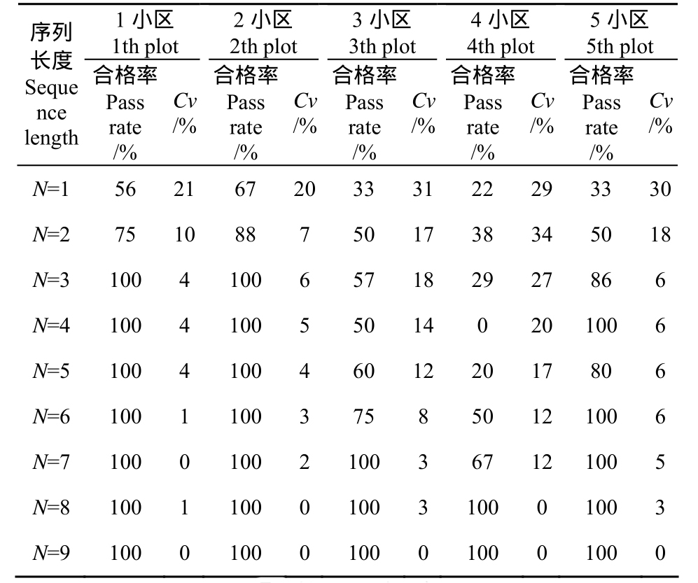
注:N表示参与计算的时间步长,1代表1年。
Note:N stand for how long time for calculating, such as 1 is one year.
1小区1th plot 2小区2th plot 3小区3th plot 4小区4th plot 5小区5th plot


 序列长度Seque nce length合格率Pass rate/%Cv/%合格率Pass rate/%Cv/%合格率Pass rate/%Cv/%合格率Pass rate/%Cv/%合格率Pass rate/%Cv/%N=1 56 21 67 20 33 31 22 29 33 30 N=2 75 10 88 7 50 17 38 34 50 18 N=3 100 4 100 6 57 18 29 27 86 6 N=4 100 4 100 5 50 14 0 20 100 6 N=5 100 4 100 4 60 12 20 17 80 6 N=6 100 1 100 3 75 8 50 12 100 6 N=7 100 0 100 2 100 3 67 12 100 5 N=8 100 1 100 0 100 3 100 0 100 3 N=9 100 0 100 0 100 0 100 0 100 0
第4小区是柑橘+百喜草全园覆盖措施,由于百喜草具有匍匐茎,生长较快,所以随着年份的增加,小区的植被覆盖度也在增加,因此,相同的雨量雨强在不同的年份,是否引起土壤侵蚀也在变化;第3小区柑橘清耕,第5小区是前埂后沟梯壁植草水平梯田,由于下垫面裸露,柑橘的生长状况直接影响植被覆盖状况,随着柑橘树的生长,植被盖度的增加,其引起土壤侵蚀的雨量雨强也会发生变化,因此该类小区满足拟定侵蚀性雨量标准的数据序列长度较长。第 1、2小区虽然措施不同,但它们的共同特点是下垫面稳定,如第1小区地表裸露,第2小区横坡耕作有定期的人为管护经营;所以这些小区在不同年份,相同雨量雨强是否引起土壤侵蚀变化不大,因而,满足拟定侵蚀性雨量标准的数据序列长度较短。
2.2 不同小区的侵蚀性雨量标准
2.2.1 侵蚀性雨量标准及其评价
基于研究区 2001—2009观测的次降雨及其对应的径流、泥沙数据,获取各小区的侵蚀性雨量标准,结果见表3。
从表中可看出,获取的每个小区侵蚀性雨量标准的相对误差很小,都在0.05%以下;错选度<8%;损失率<13%;剔除率都在65%以上。获取的各小区侵蚀性降雨标准的评价参数值与黄土高原评价参数值相近[5, 21]。
表3 各小区的侵蚀性雨量标准及其评价指标
Table 3 Erosive rainfall standard and its evaluation for each runoff plots
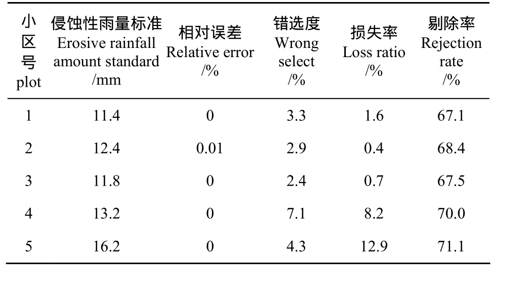
小区号plot侵蚀性雨量标准Erosive rainfall amount standard/mm相对误差Relative error/%错选度W rong select/%损失率Loss ratio/%剔除率Rejection rate/%1 11.4 0 3.3 1.6 67.1 2 12.4 0.01 2.9 0.4 68.4 3 11.8 0 2.4 0.7 67.5 4 13.2 0 7.1 8.2 70.0 5 16.2 0 4.3 12.9 71.1
2.2.2 不同小区侵蚀性雨量标准差异
从表3可以看出,不同小区的侵蚀性雨量标准差别较大。侵蚀性雨量标准最高的是柑橘+前埂后沟梯壁植草水平梯田措施的第5小区,为16.2 mm;最低的是地表裸露的第1小区,为11.4 mm;第5小区的侵蚀性雨量标准比第1小区提高了42.1%,结合已有的研究结果[19, 22]表明水土保持措施能够提高侵蚀性雨量标准。
2.3 不同小区时段侵蚀性雨强标准
2.3.1 不同时段侵蚀性雨强标准及评价
基于研究区 2001—2009年观测的次降雨及其对应的径流、泥沙数据,采用相对误差、错选度、损失率和剔除率作为评价参数,获取研究区不同水土保持措施柑橘园最大10、20、30、45和60 min的时段侵蚀性雨强标准,结果见表4。
表4 各小区不同时段最大侵蚀性降雨强度标准及其评价指标
Table 4 Maximum erosive rainfall intensity standard of different period of time and its evaluation for each plots
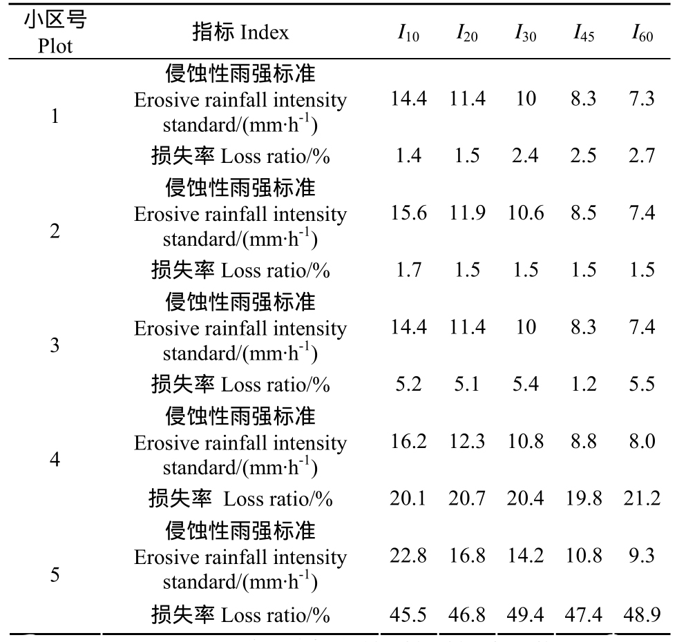
注:I10、I20、I30、I45、I60分别为最大 10、20、30、45、60 m in 的雨强。Note: I10、I20、I30、I45、I60 is maximum intensity for 10、20、30、45、60 m in ute periods respectively.
小区号Plot 指标Index I10 I20 I30 I45 I60侵蚀性雨强标准Erosive rainfall intensity standard/(mm·h-1)14.4 11.4 10 8.3 7.3 1损失率Loss ratio/% 1.4 1.5 2.4 2.5 2.7侵蚀性雨强标准Erosive rainfall intensity standard/(mm·h-1)15.6 11.9 10.6 8.5 7.4 2损失率Loss ratio/% 1.7 1.5 1.5 1.5 1.5侵蚀性雨强标准Erosive rainfall intensity standard/(mm·h-1)14.4 11.4 10 8.3 7.4 3损失率Loss ratio/% 5.2 5.1 5.4 1.2 5.5侵蚀性雨强标准Erosive rainfall intensity standard/(mm·h-1)16.2 12.3 10.8 8.8 8.0 4损失率 Loss ratio/% 20.1 20.7 20.4 19.8 21.2侵蚀性雨强标准Erosive rainfall intensity standard/(mm·h-1)22.8 16.8 14.2 10.8 9.3 5损失率Loss ratio/% 45.5 46.8 49.4 47.4 48.9
从表4可看出,不同小区时段侵蚀性雨强标准随着时段长度的增加而减小,例如最大10 min侵蚀性雨强标准都在14 mm/h以上,而最大60 min侵蚀性雨强标准都在10 mm/h以下,该规律与已有研究结果[5]相同。不同小区各时段侵蚀性雨强标准的相对误差比较小,都在0.05%以下,错选度都<20%,剔除率都>75%,但第4、5小区的损失率大于第1、2和3小区。
2.3.2 各时段不同水土保持措施柑橘园侵蚀性雨强标准的差异
从表4可看出,相同时段的各小区间侵蚀性雨强标准及其损失率存在明显差异。不同小区最大10 m in侵蚀性雨强标准差异最大,第5小区的最大10 min侵蚀性雨强标准最大,为22.8 m in/h,第1小区最小,为14.4 m in/h,相对第1小区,第5小区的最大10 m in侵蚀性雨强标准提高了58.3%。所以,水土保持措施能够明显提高最大10 min侵蚀性雨强标准;同时在最大20、30、45和60 m in的时段侵蚀性雨强标准中,也存在同样的结果。说明水土保持措施能够明显提高时段侵蚀性雨强标准。
在最大10、20、30、45和60 m in的时段侵蚀性雨强标准中,不同小区的损失率指标值存在差异;1、2、3小区损失率低,不到6%;而第4和5小区的损失率都在20%以上,尤其是5小区,其损失率接近50%。借助SPSS软件,回归不同水土保持措施柑橘园各时段侵蚀性雨强的损失率与土壤侵蚀模数的关系,得出表 5。从表中可看出,时段侵蚀性雨强标准的损失率与小区土壤侵蚀模数呈明显的负相关关系,二者关系的80%以上可用回归方程解释。
表5 时段侵蚀性降雨强度标准损失率与土壤侵蚀模数的关系
Table 5 Regression equation of erosion loss rate of erosive rainfall intensity standard and soil erosion modulus for each runoff plots
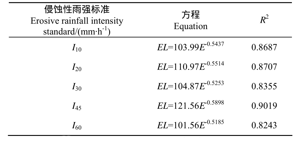
注:EL为侵蚀雨强的损失率,E为土壤侵蚀模数。
侵蚀性雨强标准Erosive rainfall intensity standard/(mm·h-1)方程Equation R2 I10 EL=103.99E-0.5437 0.8687 I20 EL=110.97E-0.5514 0.8707 I30 EL=104.87E-0.5253 0.8355 I45 EL=121.56E-0.5898 0.9019 I60 EL=101.56E-0.5185 0.8243
2.4 侵蚀性降雨标准的确定
依据侵蚀性降雨标准的相对误差、错选度、损失率及剔除率评价指标,结合已有的研究结果[5,8],对于没有水土保持措施或稳定性高的水土保持措施下垫面,宜采用时段侵蚀性雨强标准;对于稳定性较低的水土保持措施下垫面宜采用侵蚀性雨量标准。各下垫面小区的侵蚀性降雨标准确定结果见表6。
表6 各小区的侵蚀性降雨标准优选结果
Table 6 Result of erosive rainfall standard for each runoff plot
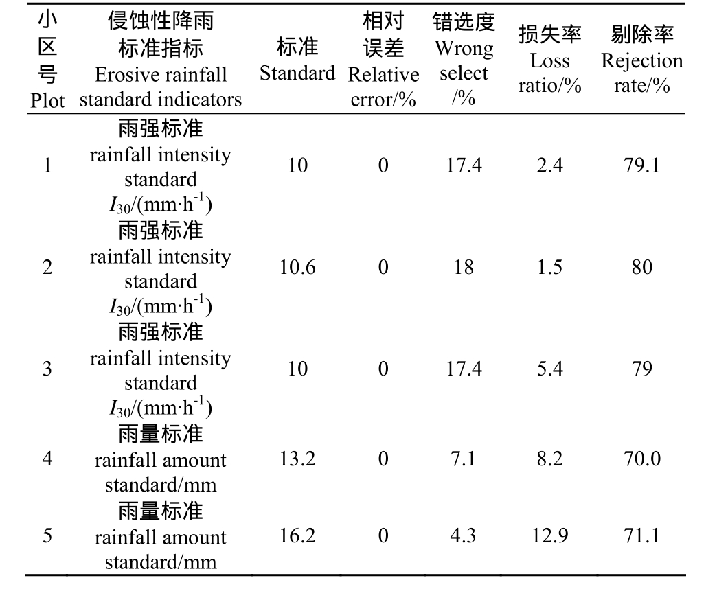
小区号Plot侵蚀性降雨标准指标Erosive rainfall standard indicators标准Standard相对误差Relative error/%错选度W rong select/%损失率Loss ratio/%剔除率Rejection rate/%1雨强标准rainfall intensity standard I30/(mm·h-1)10 0 17.4 2.4 79.1 2雨强标准rainfall intensity standard I30/(mm·h-1)10.6 0 18 1.5 80 3雨强标准rainfall intensity standard I30/(mm·h-1)10 0 17.4 5.4 79 4雨量标准rainfall amount standard/mm 13.2 0 7.1 8.2 70.0 5雨量标准rainfall amount standard/mm 16.2 0 4.3 12.9 71.1
3 讨论
利用9 a的1359场降雨及其对应的径流泥沙数据,对不同下垫面满足拟定侵蚀性降雨标准的数据序列长度及侵蚀性降雨标准进行研究。从分析中得出,不同水土保持措施下垫面小区,其满足拟定的侵蚀性雨量标准的数据序列长度不同;这可能因为水土保持措施从实施到发挥稳定效益过程中,其土壤侵蚀对降雨的响应是不断变化的[23],所以满足拟定侵蚀性雨量标准的数据序列长度的研究,可以揭示水土保持措施从实施到发挥稳定效益所需要的年限。时段侵蚀性雨强标准宜用于地表裸露或稳定性较高的水土保持措施下垫面,但对于水土保持稳定性较低的下垫面,时段侵蚀性雨强标准的损失率较高,接近50%,不宜应用,只宜应用侵蚀性雨量标准。
4 结论
1)不同下垫面满足拟定侵蚀性降雨标准的数据序列长度存在明显差异,有的只需 3 a,有的需要 8 a;通过满足拟定侵蚀性降雨标准的数据序列长度的研究,可以反映水土保持措施从实施到发挥稳定效益所需的年限,这为水土流失治理选择水土保持措施提供参考。
2)具有水土保持措施的下垫面能够有效提高侵蚀性雨量标准,优化水土保持措施配置,对提高下垫面的侵蚀性雨量标准更为有效;柑橘+前埂后沟梯壁植草水平梯田的第5小区侵蚀性雨量标准为16.2 mm,比地表裸露小区侵蚀性雨量标准11.4 mm提高42.1%。
3)水土保持措施与柑橘园结合能够有效提高柑橘园的时段侵蚀性雨强,但小区的时段侵蚀性雨强标准的损失率与土壤侵模数呈显著负相关关系;因此,对于没有水土保持措施或稳定性高的水土保持措施下垫面,宜采用时段侵蚀性雨强标准;对于稳定性低的水土保持措施下垫面宜采用侵蚀性雨量标准。
[参考文献]
[1]章文波,谢云,刘宝元. 中国降雨侵蚀力空间变化特征[J]. 山地学报,2003,21(1):33-40.Zhang Wenbo, Xie Yun, Liu Baoyuan. Spatial distribution of rainfall erosivity in China[J]. Journal of Mountain Science, 2003, 21(1): 33-40. (in Chinese with English abstract)
[2]Zhong B X, Xin X Y, Li Q Y, et al. Spatiotemporal variation in rainfall erosivity on the Chinese Loess Plateau during the period 1956-2008[J]. Regional Environment Change, 2011, 11(1): 149-159.
[3]Lee J H, Heo J H. Evaluation of estimation methods for rainfall erosivity based on annual precipitation in Korea[J]. Journal of Hydrology, 2011, 409(1-2): 30-38.
[4]Grauso S, Diodato N, Verrubbi V. Calibrating a rainfall erosivity assessment model at regional scale in Mediterranean area[J]. Environment Earth Science, 2010.60(8): 1597-1606.
[5]谢云,刘宝元,章文波. 侵蚀性降雨标准研究[J]. 水土保持学报,2000,14(4):6-11.Xie Yun, Liu Baoyuan, Zhang Wenbo. Study on standard of erosive rainfall[J]. Journal of Soil and Water Conservation, 2000, 14(4): 7-11. (in Chinese with English abstract)
[6]Zhu Q, Chen X W, Fan Q X, et al. A new procedure to estimate the rainfall erosivity factor based on Tropical Rainfall Measuring M ission (TRMM) data[J]. Science China Technological Sciences, 2011, 54(9): 2437-2445.
[7]Wischmeier W H, Sm ith D D. Rainfall energy and its relationship to soil loss[J]. Transaction of American Geophysical Union, 1958, 39(2): 285-291.
[8]Xie Y, Liu B Y, Nearing M A. Practical Thresholds for separating erosive and non-erosive storms[J]. Transaction of the ASAE, 2002, 45(6): 1843-1847.
[9]郑海金,杨洁,左长清,等. 红壤坡地侵蚀性降雨及降雨动能分析[J]. 水土保持研究,2009,16(3):30-33.Zheng Haijin, Yang Jie, Zuo Changqing, et al. Analysis of erosive rainfall and rainfall erosion energy on Red-soil slopeland[J]. Research of Soil and Water Conservatioin,2009, 16(3): 30-33. (in Chinese with English abstract)
[10]马良,左长清,邱国玉. 赣北红壤坡地侵蚀性降雨的特征分析[J]. 水土保持通报,2010,30(1):74-79.Ma Liang, Zuo Changqing, Qiu Guoyu. Erosive rainfall characteristic on red soil slope land in Northern Jiangxi Province[J]. Bulletin of Soil and Water Conservation,2010, 30(1): 74-79. (in Chinese with English abstract)
[11]马良,姜广辉,左长清,等. 江西省50余年降雨侵蚀力变化的时空分布特征[J]. 农业工程学报,2009,25(10):61-68.Ma Liang, Jiang Guanghui, Zuo Changqing, et al. Spatial and temporal distribution characteristics of rainfall erosivity changes inJiangxi province over more than 50 years[J]. Transactions of the Chinese Society of Agricultural Engineering (Transactions of the CSAE),2009, 25(10): 61-68. (in Chinese with English abstract)
[12]江西省统计局. 江西统计年鉴[M]. 北京:中国统计出版社,2011.
[13]谢颂华,曾建玲,杨洁,等. 南方红壤坡地不同耕作措施的水土保持效应[J]. 农业工程学报,2010,26(9):81-86.Xie Songhua, Zeng Jianling, Yang Jie, et al. Effects of different tillage measures on soil and water conservation in slope farm land of red soil in Southern China[J].Transactions of the Chinese Society of Agricultural Engineering (Transactions of the CSAE), 2010, 26(9): 81-86. (in Chinese with English abstract)
[14]Yu B, Rosewell C J. A robust estimate of the R-factor for the universal soil loss equation[J]. Transaction of the ASAE, 1996, 39(2): 559-561.
[15]Yu B. Rainfall erosivity and its estimation for Australia’s tropics[J]. Astralian Journal of Soil Research, 1998, 36(1):143-165.
[16]左长清,李小强. 红壤丘陵区坡改梯的水土保持效果研究[J]. 水土保持通报,2004,24(6):79-81.Zuo Changqing, Li Xiaoqiang. Effects of terrace on soil and water conservation in Red-soil hilly area[J]. Bulletin of Soil and Water Conservation, 2004, 24(6): 79-81. (in Chinese with English abstract).
[17]郑海金,杨洁,汤崇军,等. 不同水土保持耕作措施对径流泥沙与土壤碳库的影响[J]. 水土保持通报,2011,31(6):1-4,10.Zheng Haijin, Yang Jie, Tang Chongjun, et al. Impacts of different soil and water conservation tillage on runoff,sediment and soil carbon stock[J]. Bulletin of Soil and Water Conservation, 2011, 31(6): 1-4,10. (in Chinese with English abstract)
[18]Wischmeier W H, Smith D D. Predicting rainfall erosion losses: A guide to conservation planning[M]. Washington,D C: USDA, 1978: 537.
[19]刘和平,袁爱萍,路炳军,等. 北京侵蚀性降雨标准研究[J]. 水土保持研究,2007,14(1):215-217,220.Liu Heping, Yuan Aiping, Lu Bingjun, et al. Study on erosive rainfall standard of Beijing[J]. Research of Soil and Water Conservation, 2007, 14(1): 215-217, 220. (in Chinese with English abstract)
[20]金建君,谢云,张科利. 不同样本序列下侵蚀性雨量标准的研究[J]. 水土保持通报,2001,21(2):31-33.Jin Jianjun, Xie Yun, Zhang Keli. A Study on erosive rainfall standard based on different sample sizes[J].Bulletin of Soil and Water Conservation, 2001, 21(2): 31-33. (in Chinese with English abstract)
[21]谢云,章文波,刘宝元. 用日雨量和雨强计算降雨侵蚀力[J]. 水土保持通报,2001,21(6):53-56.Xie Yun, Zhang Wenbo, Liu Baoyuan. Rainfall erosivity estimation using daily rainfall amount and intensity[J].Bulletin of Soil and Water Conservation, 2001, 21(6): 53-56. (in Chinese with English abstract)
[22]王万忠. 黄土地区降雨特性与土壤流失关系的研究III—关于侵蚀性降雨的标准问题[J]. 水土保持通报,1984(2):58-63.Wang Wanzhong. Study on the relations between rainfall characteristics and loss of soil in Loess region[J]. Bulletin of Soil and Water Conservation, 1984(2): 58-63. (in Chinese with English abstract)
[23]章文波,付金生. 不同类型雨量资料估算降雨侵蚀力[J]. 资源科学,2003,25(1):35-42.Zhang Wenbo, Fu Jinsheng. Rainfall erosivity estimation under different rainfall amount[J]. Resources Science,2003, 25(1): 35-42. (in Chinese with English abstract)
Research for standard of erosive rainfall on Quaternary Red Soil area in north of Jiangxi province in China
Abstract: Rainfall is regarded as one of the principal dynamic factors of soil erosion. The attainment of an erosive rainfall standard is acknowledged as the essential part in calculating rainfall erosivity. At present, results of research for an erosive rainfall standard are diverse in the red soil area. Hence, it deserves to be studied to a further extent. On the basis of the observation of runoff plots, the standard of erosive rainfall was comparatively analyzed under different soil and water conservation measures employing five types of underlying surface in the Quatenary red earth area of Northern Jiangxi province, including bare surface, citrus with cross-slope cultivation,citrus with clean cultivation, citrus with bahia grass covering, citrus with bench terrace with grass planted on the wall and mound before but ditch behind. Viewing it from the perspective of energy, this study sought for the standard amount of erosive rainfall with the indicator of EI30 and the standard intensity of erosive rainfall with the indicators of EI10、EI20、EI30、EI45、EI60 with reference to the rainfall amount and intensity of 1359 times during the period of 2001-2009 and the corresponding data of runoff and sediment observed on the condition of different soil and water conservation measures with five above-mentioned types of underlying surface. Compared with slope lands of bare surface and citrus with clean cultivation as a control, the study elaborated the feature of an erosive rainfall standard for citrus with soil and water conservation measures. The results of this study were intended to reveal the reduction mechanisms of runoff and sediment for red-soil slop lands under soil and water conservation measures, to provide a data basis for the enhancement of the local forecast accuracy for soil erosion and water loss and to supply scientific evidence for regional soil and water conservation planning at the same time.The conclusions of the study can be drawn as follows: 1) There were significant discrepancies in the length of the data sequence of different underlying surface when satisfying the proposed standard of erosive rainfall and the length of data sequence satisfying the proposed erosive rainfall standard is capable of revealing the time period which was required from the implementation of soil and water conservation measures to its production of stable benefits; 2) The underlying surface with soil and water conservation measures is effective enough to raise the amount standard of erosive rainfall, illustrating like the standard amount of erosive rainfall observed from the fifth plot employing citrus and bench terrace with grass planted on the wall and mound before but ditch behind was 16.2 mm, increasing 42.1% in comparison with the standard amount of erosive rainfall of 11.4 mm observed from the bare surface plot; 3) It is advisable to apply a standard intensity of erosive rainfall to the underlying surface with a high stability or without soil and water conservation measures, while with regard to those underlying surface with low stability, the standard amount of erosive rainfall is considered to be more suitable to employ. The results of this study may provide a reference for the planning of soil and water conservation in Quaternary Red soil area.
Key words: runoff, sediments, erosion, erosive rainfall standard, soil and water conservation, Quaternary Red Soil area
doi:10.3969/j.issn.1002-6819.2013.11.013
中图分类号:S157.1
文献标志码:A
文章编号:1002-6819(2013)-11-0100-07
汪邦稳,方少文,宋月君,等. 赣北第四纪红壤区侵蚀性降雨强度与雨量标准的确定[J]. 农业工程学报,2013,29(11):100-106.
Wang Bangwen, Fang Shaowen, Song Yuejun, et al. Research for standard of erosive rainfall on Quaternary Red Soil area in north of Jiangxi province in China[J]. Transactions of the Chinese Society of Agricultural Engineering (Transactions of the CSAE), 2013, 29(11): 100-106. (in Chinese with English abstract)
收稿日期:2012-11-20
修订日期2013-04-25
基金项目:国家自然科学基金(41201276);水利部公益性行业科研专项经费项目(201301050)。
※通信作者:杨 洁(1958-),女,汉族,福建漳浦人,教授级高级工程师。主要研究方向为水土保持、森林培育。南昌 江西省水土保持科学研究院,330029。Email:zljyj@126.com