水文模型在估算冰川径流研究中的应用现状
【类型】期刊
【作者】尹振良,冯起,刘时银,邹松兵(中国科学院 寒区旱区环境与工程研究所 内陆河流域生态水文重点实验室;中国科学院寒区旱区环境与工程研究所 阿拉善荒漠生态 水文试验研究站;中国科学院寒区旱区环境与工程研究所 冰冻圈科学国家重点实验室;中国科学院 寒区旱区环境与工程研究所 内陆河流域生态水文重点实验室)
【作者单位】中国科学院 寒区旱区环境与工程研究所 内陆河流域生态水文重点实验室;中国科学院寒区旱区环境与工程研究所 阿拉善荒漠生态 水文试验研究站;中国科学院寒区旱区环境与工程研究所 冰冻圈科学国家重点实验室;中国科学院 寒区旱区环境与工程研究所 内陆河流域生态水文重点实验室
【刊名】冰川冻土
【关键词】 冰川径流;水文模型;径流贡献;应用进展
【资助项】国家自然科学基金项目(41190084,30970492,41571031);中国科学院科技创新交叉与合作团队项目;中国博士后科学基金项目(2015m572620);中国科学院寒区...
【ISSN号】1000-0240
【页码】P248-258
【年份】2019
【期号】第1期
【期刊卷】1;|7;|8;|2
【摘要】冰川径流估算是气候变化风险评估和水资源可持续管理的重要内容.冰川径流估算方法主要包括:直接观测法、冰川物质平衡法、水量平衡方程法、水化学示踪法和水文模型法.本文首先对五种方法的应用情况进行简要总结,进而重点阐述水文模型法在估算冰川径流研究中的应用现状.水文模型法是冰川径流估算研究中使用最频繁的方法,使用方式主要包括耦合冰川模块和开发新的冰川水文模型.冰川水文模型中的消融算法主要包括温度指数模型(度日因子法)、修正的温度指数模型、能量平衡模型.受当前观测条件限制,修正的温度指数模型兼顾能量平衡模型和温度指数模型的优势而成为冰川水文模型中最流行的方法.随着学科的发展进步,能量平衡模型与水文模型的耦合将会成为未来的研究重点,发展大尺度分布式冰川水文模型是冰川水文学的未来发展方向之一.
【全文】 文献传递
水文模型在估算冰川径流研究中的应用现状
摘 要:冰川径流估算是气候变化风险评估和水资源可持续管理的重要内容.冰川径流估算方法主要包括:直接观测法、冰川物质平衡法、水量平衡方程法、水化学示踪法和水文模型法.本文首先对五种方法的应用情况进行简要总结,进而重点阐述水文模型法在估算冰川径流研究中的应用现状.水文模型法是冰川径流估算研究中使用最频繁的方法,使用方式主要包括耦合冰川模块和开发新的冰川水文模型.冰川水文模型中的消融算法主要包括温度指数模型(度日因子法)、修正的温度指数模型、能量平衡模型.受当前观测条件限制,修正的温度指数模型兼顾能量平衡模型和温度指数模型的优势而成为冰川水文模型中最流行的方法.随着学科的发展进步,能量平衡模型与水文模型的耦合将会成为未来的研究重点,发展大尺度分布式冰川水文模型是冰川水文学的未来发展方向之一.
关键词:冰川径流;水文模型;径流贡献;应用进展
0 引言
冰川是全球气候变化的敏感指示器[1].受气候变化影响,世界上绝大部分山区的冰川处于退缩中,并呈现加速趋势[2-3],导致很多流域水文过程发生显著变化[4-6],尤其对于高寒山区的冰川积雪流域[7-8].冰川变化对未来生态与环境安全和社会经济等将产生广泛和深刻的影响[7-8],气温升高会使雨/雪比率增大,加速春季融雪的速率,导致更快、更早和更大的春季径流,气候变化引起高寒山区各种介质中的水循环变化加快[10],从而影响中下游地区供水、粮食安全以及水电能源生产等社会经济活动 [11].
目前,冰川、积雪融水的时空变化、冰川径流的贡献等问题,都是不确定的[12-13].准确计算冰川径流量是冰川流域气候变化风险评估和水资源可持续管理不可或缺的一部分[14-16].但是,冰川径流估算是一项具有挑战性的工作[17],因为冰川消融过程和流域水文过程都非常复杂,高寒山区流域山高坡陡、地形复杂、缺少观测资料,详细的气象、水文、冰川观测数据仅局限于少部分容易到达、具有较好研究基础的流域[18-19].
针对当前问题,学者们进行了很多研究,产生了许多计算冰川径流的方法,大致可以概括为五种[17]:1) 直接观测法;2) 冰川物质平衡法;3) 水量平衡方程法;4) 水化学示踪法;5) 水文模型法.本文首先对这五种方法进行简要概括,然后着重对水文模型法的应用现状进行总结.
1 冰川径流的定义
关于冰川径流(glacier runoff)的定义,根据研究方法、对象、目的不同而有所差别[20].主要包括以下几种[21]:
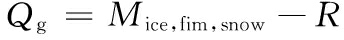
1) 冰川径流即冰川区的总径流(例如,Nepal等[22]),包括冰川、积雪融水径流、降雨产流以及冰川区的其它径流成分.此种情况下,冰川径流计算公式如下所示:

(1)
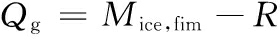
2) 冰川径流指冰川区的融水径流,包括冰川融化和积雪融化所产生的径流(例如,Cogley等[23] ),计算公式如下所示:
(2)
3) 冰川径流指冰川融化所产生的径流,不包括积雪融化产生的径流(例如,Weber等 [24]),计算公式如下所示:
(3)
式中:Qg为冰川径流量;P1为液态降水量;E为蒸发量(包括升华);M为融水量;R为再冻结量.
另外,也有文献将冰川径流定义为冰川物质亏损产生的水当量(例如,Huss[25])、冰川平衡状态下的年积雪量[26]等.前三种定义方式下,不管冰川处于何种平衡状态,冰川径流均会对河道径流产生影响,因此,本文主要讨论前三种定义方式下冰川径流的计算问题.
2 冰川径流计算方法
2.1 直接观测法
直接观测法是通过在冰川末端建立观测站点,观测冰川径流量,同时在下游某处(例如,出山口)再设立观测点,观测河道径流量,计算冰川径流对河道径流的贡献[27-29].该方法最简单直接、对数据依赖性最小,但是冰川流域必须能到达且适合建立观测点.
Gascoin等[27]在安第斯山脉对五个不同冰川覆盖度(0.4%~11%)的冰川流域进行观测,表明冰川径流对流域年径流量的贡献为3.3%~23%.Nolin等[28]对美国俄勒冈地区的两个冰川小流域的夏季径流进行观测,表明2007年8月10日至9月7日之间,冰川融水对流域径流的贡献分别为87%和31%.Thayyen等[29]在喜马拉雅山区的冰川小流域按不同海拔梯度设立三个观测点(从冰川末端到2 360 m a.s.l.),用以研究消融期降水和冰川融水对总径流的贡献.
在我国天山冰川站,自1959年以来对1号冰川进行了长时间序列的观测[30],是我国监测时间最长、资料最为详尽、系统的冰川[3];1959年4月至1960年3月期间,中国珠峰科学考察队在绒布寺附件海拔5 000 m的中绒布冰川末端进行了一个完整水文年的水位流量观测[31].自2005年以来,中国科学院青藏高原研究所在青藏高原纳木错流域扎当冰川建立站点,对冰川区径流、气温和降水量等进行观测[32].自1989年开始,基于中日联合青藏高原冰川考察课题,在唐古拉山口冬克玛底冰川进行冰川、水文和气候学观测,至今连续观测20余年[33].
2.2 冰川物质平衡法
如果冰川融化的体积能够计算,则可以通过计算水当量估算冰川径流.冰川物质平衡法的关键是计算融冰的体积.研究人员很早便开始借助于冰川物质平衡和气象、水文观测数据来计算冰川融水径流[34-35],如今这种方法在具有较好观测基础的冰川流域仍然是一种不错的选择[25,36-37].计算冰川物质平衡的常用方法包括花杆观测法、冰川面积-体积关系法和能量平衡模型.
Huss[25]利用阿尔卑斯山区50多条冰川1908-2008年之间的物质平衡数据计算发源于该地区的四条著名河流(莱茵河、罗纳河、波河、多瑙河)夏季冰川径流量.Lambrecht等[36]利用奥地利1969-1998年之间的冰川负物质平衡数据计算两个冰川流域的径流变化情况,结果表明冰川消融引起夏季径流增加10%~15%.Pelto[37]利用冰川物质平衡数据对华盛顿北瀑布山地区冰川退缩对径流的影响进行研究,表明1958-2009年间冰川面积减少45%,冰川融水径流减少38%.
在国内,沈永平等[38]重建了台兰河流域平均冰川物质平衡序列,表明由升温引起的冰川净消融相当于每年补给河流径流1.24×10⁸ m3,占河流年径流量的15%.能量平衡模型是估算冰川表面消融量最准确的方法之一.卿文武等[39]在天山南坡科其喀尔巴西冰川建立能量平衡模型,对冰川消融进行估算.度日模型是冰川与积雪表面消融能量平衡这一复杂过程的简化描述,但在流域尺度上可以给出类似于能量平衡模型的理想输出结果[40].刘时银等[41]利用观测的冰川物质平衡数据结合度日公示计算长江源区冰川融水对径流的贡献,结果表明,1961-2000年间冰川融水对径流的贡献为11.0%,进入1990年代以后,冰川融水的贡献达到17.0%.高鑫等[42]利用度日模型重建了塔里木河流域各水系冰川物质平衡、融水径流序列,并应用冰川物质平衡资料等进行验证,结果表明冰川融水对塔里木河总径流的平均补给率为41.5%.随着计算机性能的提高和遥感技术的发展,冰川分布式能量-物质平衡模型得到了较大的发展应用,王宁练等[43]基于“七一”冰川物质平衡、水文气象观测资料,结合DEM数据,建立了一个冰川分布式能量-物质平衡模型,并对融水径流进行计算.
2.3 水量平衡法
水量平衡法是通过水量平衡方程计算冰川径流量.若忽略冰川升华等过程,水量平衡方程可以简化为:

(4)
式中:Q为冰川流域总径流量;P为降水量;(G为冰川融水量;GW为流入深层地下水量;E为实际蒸散发量.
Singh等[44]等利用水量平衡法估算冰雪融水对喜马拉雅山脉西部Chenab河径流量的贡献,表明冰雪融水约占总径流的49%.Aizen等[45]利用水量平衡法计算天山北部冰川流域的径流比例,结果表明,降水直接产流占12%,冰川融水占18%~28%,季节性积雪融水占18%,地下水占34%~38%.受全球气候变化影响,热带布兰卡山脉(Cordillera Blanca)地区的冰川正快速退缩,导致流域水文过程发生变化,Baraer等[46]对该地区九个冰川小流域的日径流数据进行分析,并根据水量平衡原理计算冰川径流变化对总径流的影响.
为探讨青藏高原湖泊面积变化的主导因素,朱立平等[47]从湖泊水量平衡角度分析,表明冰川融水增加对湖泊总补给增量的贡献率高达52.86%,说明冰川融水增加是引起近年纳木错湖面迅速扩张的主要原因.张寅生等[48]通过水量平衡分析确定青藏高原唐古拉山冬克玛底河流域冰川融水对径流的补给率为49%,冰川融水径流主要产生于7-9月,时间短,强度大.周石硚等[49]通过在喜马拉雅山中东段蒙达扛日冰川进行观测并通过水量平衡分析表明,上、下游断面控制流域内由冰川消融所贡献的流域径流深分别为501 mm和417 mm.
2.4 水化学示踪法
不同来源的径流成分,因为所经过的水流路径和地质单元不同而具有特殊的水化学特征,因此,可以通过分析径流中的水化学特征而计算各组成成分的比例[50-51].水化学示踪法计算冰川径流量即通过分析冰川融水和总径流中的水化学特征,并利用端元混合模型计算冰川融水径流[52].常用的端元混合模型有二端元模型(冰川融水、非冰川融水)和三端元混合模型(冰川融水、地表径流、地下径流)[52-54].水体中的氢氧同位素(18O、2H),因其性质相对稳定、主要受蒸散发的影响等原因,也经常作为示踪剂用于计算冰川径流[55].
针对高寒山区冰川作用流域不同径流成分的贡献以及冰川融水对径流的影响等问题,Brown等[56]在法国冰川小流域(43°6′ N、0°10′ W)基于消融期野外观测数据,采用水化学示踪法进行研究,表明河道径流为冰川融水-地下水补给型.Mark等[52]利用水化学示踪剂和端元混合模型计算南美洲布兰卡山脉Callejon de Huaylas流域不同空间尺度冰川融水对径流的贡献,表明冰川融水对该流域径流的贡献超过50%.Wind River流域是北美落基山脉地区冰川分布最集中的地区,然而冰川融水对流域总径流的贡献仍然未确定,为此Cable等[54]利用氢氧同位素和贝叶斯模型计算不同时间尺度下冰川融水的贡献,表明冰川退缩会在夏末和降雪较少的年份影响河岸生态系统和人类供水.Penna等[57]基于水化学示踪法对阿尔卑斯山区冰川小流域(流域面积61.7 km2)水资源进行时空分析,表明积雪融水和冰川融水是该地区春末、夏季和秋初最主要的径流成分.
在国内,尹观等[58]应用示踪技术,对贡嘎山海螺沟冰川河源区和干流的不同区段、不同时域径流的组成特点及其水文动态变化规律进行分析研究,表明冰川消融对径流的贡献可达69%~78%.针对高寒水源区不同景观带冰川、积雪、冻土、地表水、地下水和降雨等水体对出山径流的贡献问题,杨永刚等[59]应用同位素和水化学示踪法确定祁连山区葫芦沟小流域冰雪带融水占11%.另外,通过氢氧同位素变化特征对托木尔峰青冰滩72号冰川流域进行径流分割显示[59],冰川融水所占比率为74.8%,降水所占比率为25.2%,冰川融水是径流的主要补给来源.
2.5 水文模型法
水文模型法是冰川径流估算方法中使用最频繁的方法[17].水文模型通过一系列嵌套方程来求解水量平衡,模拟水量平衡成分的时间和空间变化[57].按模型对过程刻画的详细程度,通常将水文模型分为物理模型和概念模型[62],各有利弊.物理模型基于严格的物理方程,具有较高的时空分辨率,但却需要大量的数据支持[25,63];概念模型基于水文、气象实测数据建立统计关系,忽略了小尺度的物理过程,仅需要较少的观测数据,相对于偏远、缺资料流域而言,比较容易构建[64].关于水文模型法计算冰川径流的应用状况,下一部分进行详细总结.
3 水文模型在冰川径流估算研究中的应用
目前,利用水文模型计算冰川径流量通常有两种形式:1) 将冰川模块嵌入到已有水文模型中,弥补原有水文模型对冰川径流过程刻画不足的缺陷,例如刘伟刚等[65];2) 开发新的冰川水文模型,例如Huss等[8].冰川消融算法主要基于温度指数模型(度日因子法)和修正的温度指数模型,能量平衡模型也逐渐开始与水文模型耦合.具体如下:
3.1 温度指数模型
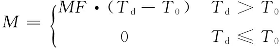
虽然冰川与积雪消融过程取决于表面的能量收支状况,但对于能量平衡模型而言,该方法涉及的参数较多、计算过程复杂,在偏远的高寒山区很难推广.Finsterwalder等[66]指出冰雪融化与气温之间存在密切关系.因此,基于单一气候因子的度日模型在冰川与积雪研究中应用较为广泛[67].温度指数模型是基于气温和冰川消融量建立的经验统计关系,因其输入数据简单、易获取、易处理等优点[67],被广泛应用于冰川径流模拟研究中[63,68-71].温度指数模型(temperature-index model)如下所示:
(5)
式中:M为日消融量(mm);Td为日平均气温(℃);T0为冰川消融阈值温度(℃);MF为温度消融因子(mm·℃-1·d-1).
Singh等[72-73]基于温度指数模型开发了一个概念性融雪模型(SNOWMOD),并应用于喜马拉雅山西部和中部地区冰川、积雪融水对径流的贡献研究中.Schaefli等[69]也基于温度指数模型开发了一个概念性冰川水文模型GSM-SOCONT,并将观测的冰川物质平衡数据用于模型校准[71],取得较好效果.在众多水文模型中,基于温度指数模型开发的HBV模型[74]演变出多种版本,并被应用于多个冰川流域,用于计算冰川、积雪融水径流,主要包括HBV-ETH[64,75],HBV-EC[76-77],HBV-Met[78],HBV-PRECIS[78],HBV-Light[79]等.除开发新的水文模型外,Konz等[80]利用TACD模型对喜马拉雅山区某冰川小流域(360 km2)进行径流模拟.Comeau等[81]利用WATFLOOD模型对加拿大落基山区冰川退缩和季节性消融对出山径流的贡献进行研究.以上两模型中,均基于温度指数模型计算冰川、积雪融水.另外,Luo等[82]基于冰川物质平衡理论提出了一个集冰川融化、升华、蒸发、累积等过程的冰川模块,并采用动态水文响应单元(HRU)的方法,将冰川模块与SWAT(Soil and Water Assessment Tool)模型耦合,在天山玛纳斯河流域进行了冰川径流过程模拟.Boscarello等[63]在分布式水文模型FEST-WB中引入基于温度指数模型的冰川模块,并对瑞士罗纳河流域(Swiss Rhone Basin)进行径流模拟,表明夏季径流40%来自冰川融水.
在国内,高洪凯等[83]采用HBV模型对长江源区冬克玛底流域冰川径流进行模拟,表明1955-2008年间径流呈波动增加趋势,径流的增加中65%是因为温度升高导致冰川消融加剧所致;李晶等[84]利用融雪径流模型(SRM)对天山托木尔峰南坡科其喀尔冰川径流进行径流模拟,基于两年的实测数据确定了各月积雪、裸冰以及表碛覆盖冰的度日因子值;杨淼等[85]利用HBV-ETH模型对天山1号冰川日径流进行模拟,并考虑度日因子和冰川面积的变化.
温度指数模型能够获取类似于能量平衡模型的输出结果[40].但是,不足之处在于:1) 虽然模型在较长时间段内能够取得较为理想的模拟结果,但其精度随着时间分辨率的提高而逐渐降低;2) 受地形及冰川与积雪表面条件的影响,模型对冰雪表面消融状况的空间变化特征无法精确描述[67].
3.2 修正的温度指数模型
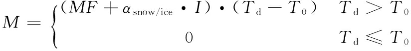
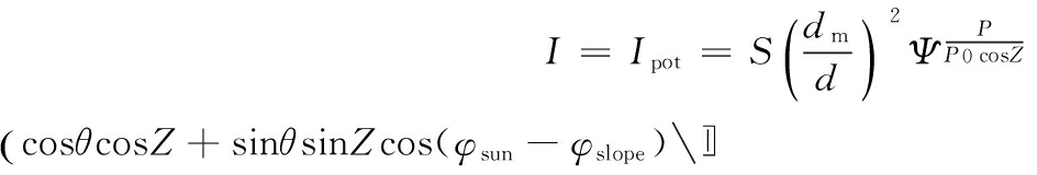
太阳辐射是冰川、积雪表面能量平衡中的重要因子[86].对冰川消融区的观测研究表明,净辐射是消融期的主要能量来源[87].为提高模型的时空精度,Hock[88]和Pellicciotti等[89]先后在温度指数模型中引入辐射因子的影响,即为修正的温度指数模型(distributed temperature-index model 或 enhanced temperature-index model),Hock[88]提出的模型如下:
(6)
式中:αsnow/ice为辐射消融因子(m2·mm·W-1·d-1·℃-1);I为辐射项(W·m-2),受遮蔽、坡度、坡向,季节、时间等因素影响.根据有无实测资料,辐射项I有不同的计算方式,在没有任何观测资料的情况下,I为潜在太阳总辐射Ipot:
(7)
当有实测资料时,I计算方式如下:
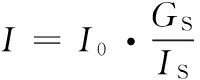
(8)
式中:I0为潜在短波辐射(W·m-2);IS为台站观测的短波辐射(W·m-2);GS为台站观测的太阳总辐射(W·m-2).
Pellicciotti等在Hock的基础上,将辐射项对消融的影响单独分离出来,物理意义更加明确,计算方式如下:
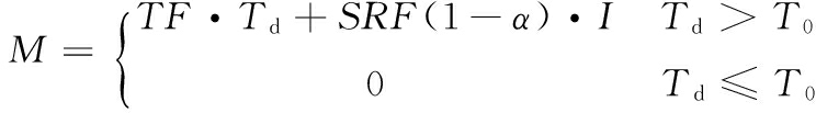
(9)
式中:TF为温度消融因子(mm·d-1·℃-1);SRF为短波辐射消融因子(mm·m2·d-1·W-1);α为表面反照率;I为入射短波辐射(W·m-2).
Kustas等[90]研究表明,引入辐射因子后,SRM模型评价系数比传统方法提高近40%;Hock[88]在融入晴天直接辐射之后的研究也表明,在小时尺度上修正的温度指数模型较传统温度指数模型模拟效果有显著提高;Pellicciotti等[89]对四种不同形式的修正温度指数模型进行了对比研究.国内,在天山科其喀尔巴西冰川消融估算的研究中也表明,修正的温度指数模型优于传统温度指数模型[91-92].
由于坡度、坡向、遮蔽等地形条件的影响,冰川、积雪消融速率在空间上存在较大地差异.为了充分表达冰川、积雪消融差异,很多学者通过将修正的温度指数模型与空间分布式水文模型耦合,在栅格单元或水文响应单元尺度模拟冰川、积雪消融状况.Verbunt等[93]将修正的温度指数模型与基于栅格的分布式水文模型WaSiM进行耦合(WaSiM-ETH模型),用以模拟瑞士高寒山区流域的冰川融水对径流的贡献;Koboltschnig等[94-95]利用空间分布式概念性水文模型PREVAH,对阿尔卑斯山的冰川小流域进行冰川、积雪融水模拟,冰川融水模块基于修正的温度指数模型;Finger等[96]将修正的温度指数模型与基于物理过程的分布式水文模型TOPKAPI耦合,用以模拟阿尔卑斯山区未来气候变化情景下水资源的变化和不确定性以及对水利发电的影响,表明冰川融水和降雨径流在春季增加,夏季减少;基于修正的温度指数模型开发的分布式概念性水文模型GERM(Glacier Evolution Runoff Model)在阿尔卑斯山区得到了很好的应用[8,25],Farinotti等[61]的研究表明在气候变化背景下阿尔卑斯山区冰川流域将会发生“冰川-冰川、积雪-积雪”型的转变;Gabbi等[97]根据冰储量预测阿尔卑斯山区的冰川融水径流变化,指出冰储量的估算对融水径流的预测至关重要.Nepal等[22]基于修正的温度指数模型开发了分布式物理水文模型J2000,并应用于喜马拉雅山区中尺度流域冰川融水径流的模拟,结果表明,冰川区产水对总径流的贡献为17%.
修正的温度指数模型更接近于能量平衡的模拟效果,也能够根据不同地形条件、不同时段建立空间分布式消融模型,进而通过与分布式水文模型耦合模拟冰雪融水径流的时空分布规律.但是,修正的温度指数模型中关键的温度消融因子(MF)和辐射消融因子(αsnow/ice)仍属于经验参数,虽然消融因子可以通过观测获取,但对于大多数冰川而言,受地形条件的限制,仍然难以观测.
3.3 能量平衡模型
随着典型冰川区各种自动水文、气象仪器的布设,消融和辐射平衡观测数据的积累以及冰川消融理论的发展,具有物理机制的能量平衡模型成为研究冰川消融的另一个选择[98].能量平衡模型利用冰雪-大气界面多余的能量通量转化为融化的水当量,一般形式如下:

(10)
式中:a为融化的水当量(m w.e.);Δt为模拟时间步长;ρw为水密度(1 000 kg·m-3);Lf为冰的融解热(3.34×10⁵ J·kg-1);α为冰雪反照率;SW↓为入射短波辐射;LW↓和LW↑为入射和反射的长波辐射;QH为感热通量(W·m-2);QL为潜热通量(W·m-2);QS为冰川积雪表面以下热传输项(W·m-2).
Pellicciotti等[89]和Carenzo等[99]分别在阿尔卑斯山区的冰川径流模拟中,利用能量平衡模型的输出数据校准修正的温度指数模型;Ragettli等[100]在安第斯山脉冰川流域的径流模拟中,将小时尺度的能量平衡模型输出数据用于TOPKAPI水文模型的参数校准;赵求东等[101]在分布式水文模型VIC的框架基础上成功耦合了能量-物质平衡方案,用于阿克苏河两大支流的冰川径流模拟中,结果表明,托什干河和昆马力河冰川区径流分别占29.2%和58.7%;Gabbi等[102]在阿尔卑斯山区的冰川流域分别将基于气象因子的经验统计模型(温度指数模型、修正的温度指数模型)和基于物理过程的能量平衡模型(简单的能量平衡模型、复杂的能量平衡模型)与冰川演进模型耦合,模拟长时间序列的冰川累积与消融.
表1 主要冰川水文模型总结比较
Table 1 Comparison and summary of main glacio-hydrological models
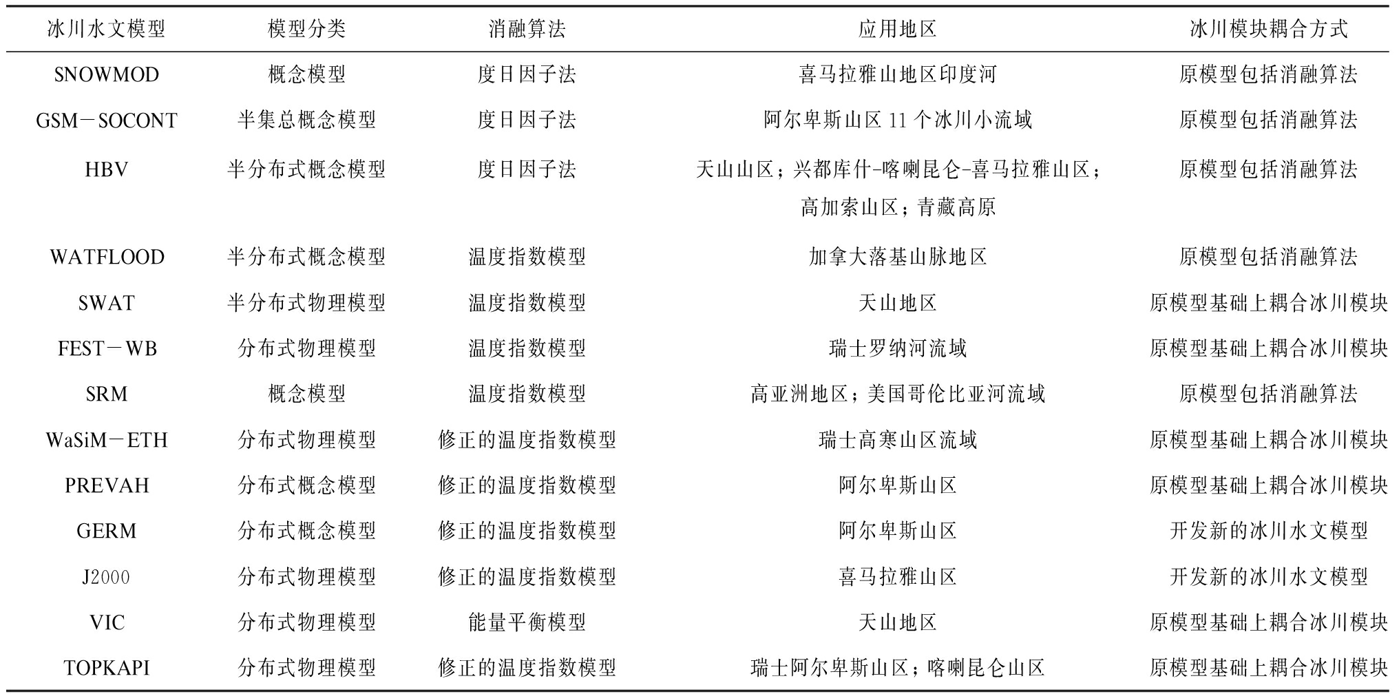
冰川水文模型模型分类消融算法应用地区冰川模块耦合方式SNOWMOD概念模型度日因子法喜马拉雅山地区印度河原模型包括消融算法GSM-SOCONT半集总概念模型度日因子法阿尔卑斯山区11个冰川小流域原模型包括消融算法HBV半分布式概念模型度日因子法天山山区;兴都库什喀喇昆仑喜马拉雅山区;高加索山区;青藏高原原模型包括消融算法WATFLOOD半分布式概念模型温度指数模型加拿大落基山脉地区原模型包括消融算法SWAT半分布式物理模型温度指数模型天山地区原模型基础上耦合冰川模块FEST-WB分布式物理模型温度指数模型瑞士罗纳河流域原模型基础上耦合冰川模块SRM概念模型温度指数模型高亚洲地区;美国哥伦比亚河流域原模型包括消融算法WaSiM-ETH分布式物理模型修正的温度指数模型瑞士高寒山区流域原模型基础上耦合冰川模块PREVAH分布式概念模型修正的温度指数模型阿尔卑斯山区原模型基础上耦合冰川模块GERM分布式概念模型修正的温度指数模型阿尔卑斯山区开发新的冰川水文模型J2000分布式物理模型修正的温度指数模型喜马拉雅山区开发新的冰川水文模型VIC分布式物理模型能量平衡模型天山地区原模型基础上耦合冰川模块TOPKAPI分布式物理模型修正的温度指数模型瑞士阿尔卑斯山区;喀喇昆仑山区原模型基础上耦合冰川模块
能量平衡模型基于能量平衡原理,能够从物理机制上详细揭示冰川消融过程,而且能够输出较高时间分辨率(小时尺度)的冰川径流数据,但是由于其输入参数较多,理论和结构较复杂,加上大部分偏远地区的冰川无法进行监测等原因,导致能量平衡模型很难与水文模型进行耦合.目前关于水文模型中耦合能量平衡模型的研究还相对较少.
主要冰川水文模型总结比较如表1所示.
4 小结
气候变化背景下,准确计算冰川径流量是冰川流域气候变化风险评估和水资源可持续管理的重要工作.目前,该方面的研究已取得较大进展[17,86,98],形成了许多研究方法,按照研究手段主要分为直接观测法、冰川物质平衡法、水量平衡方程法、水化学示踪法和水文模型法.在具体研究过程中,往往是两种或多种方法结合使用,例如Nolin等[28]使用了直接观测法、氧同位素示踪法和水文模型法同时计算冰川径流的贡献.水文模型法是使用最频繁的一种方法.因为气温通常最容易获取,而且便于进行空间插值,所以水文模型中的冰川模块主要是基于温度指数模型和修正的温度指数模型;基于物理机制的能量平衡模型,因其输入参数较多、理论结构复杂,目前还难以与水文模型耦合.能量平衡模型与分布式水文模型的耦合将会成为未来的研究重点[103].
受全球变暖的影响,冰川萎缩成为普遍趋势,预估未来50年中国冰川面积将进一步减少30%左右[104].冰川径流在气候变化背景下的变化趋势成为冰川学家们关注的热点,水文模型便于通过进行假设情景或与气候模式输出数据耦合而模拟冰川径流变化趋势,成为研究冰川径流对气候变化未来响应的有效工具[17].目前,在很多典型冰川流域已积累了较多观测数据,并进行了大量研究,如何将区域尺度的研究成果推广到研究基础薄弱的冰川流域,发展基于物理机制的大尺度分布式冰川径流模型也是方向之一.
参考文献(References):
[1] Fischer A.Glaciers and climate change: interpretation of 50 years of direct mass balance of Hintereisferner[J].Global and Planetary Change,2010,71(1/2): 13-26.
[2]Haeberli W,Barry R,Cihlar J.Glacier monitoring within the Global Climate Observing System[J].Annals of Glaciology,2000,31: 241-246.
[3]Li Zhongqin,Shen Yongping,Wang Feiteng,et al.Response of glacier melting to climate change: take Ürümqi Glacier No.1 as an example[J].Journal of Glaciology and Geocryology,2007,29(3): 333-342.[李忠勤,沈永平,王飞腾,等.冰川消融对气候变化的响应: 以乌鲁木齐河源1号冰川为例[J].冰川冻土,2007,29(3): 333-342.]
[4]Barry R G.The status of research on glaciers and global glacier recession: a review[J].Progress in Physical Geography,2006,30(3): 285-306.
[5]Zemp M,Hoelzle M,Haeberli W.Six decades of glacier mass-balance observations: a review of the worldwide monitoring network[J].Annals of Glaciology,2009,50: 101-111.
[6]Casassa G,L pez P,Pouyaud B,et al.Detection of changes in glacial run-off in alpine basins: examples from North America,the Alps,central Asia and the Andes[J].Hydrological Processes,2009,23(1): 31-41.
[7]Parry M L,Canziani O F,Palutikof J P,et al.Contribution of working group II to the fourth assessment report of the Intergovernmental Panel on Climate Change[M].Cambridge,UK: Cambridge University Press,2007.
[8]Huss M,Farinotti D,Bauder A,et al.Modelling runoff from highly glacierised alpine drainage basins in a changing climate[J].Hydrological Processes,2008,22(19): 3888-3902.
[9]Yao Tandong,Qin Dahe,Shen Yongping,et al.Cryospheric changes and their impacts on regional water cycle and ecological conditions in the Qinghai-Tibetan Plateau[J].Chinese Journal of Nature,2013,35(3): 179-186.[姚檀栋,秦大河,沈永平,等.青藏高原冰冻圈变化及其对区域水循环和生态条件的影响[J].自然杂志,2013,35(3): 179-186.]
[10] Shen Yongping,Su Hongchao,Wang Guoya,et al.The responses of glaciers and snow cover to climate change in Xinjiang (I): hydrological effects[J].Journal of Glaciology and Geocryology,2013,35(3): 513-527.[沈永平,苏宏超,王国亚,等.新疆冰川、积雪对气候变化的响应(I): 水文效应[J].冰川冻土,2013,35(3): 513-527.]
[11] Immerzeel W W,van Beek L P H,Bierkens M F P.Climate change will affect the Asian water towers[J].Science,2010,328(5984): 1382-1385.
[12] Bolch T,Kulkarni A,Kääb A,et al.The state and fate of Himalayan glaciers[J].Science,2012,336(6079): 310-314.
[13] Moors E J,Groot A,Biemans H,et al.Adaptation to changing water resources in the Ganges basin,northern India[J].Environmental Science & Policy,2011,14(7): 758-769.
[14] Miller J D,Immerzeel W W,Rees G.Climate change impacts on glacier hydrology and river discharge in the Hindu Kush-Himalayas[J].Mountain Research and Development,2012,32(4): 461-467.
[15] Schaner N,Voisin N,Nijssen B,et al.The contribution of glacier melt to streamflow[J].Environmental Research Letters,2012,7(3).doi:10.1088/1748-9326/7/3/034029.
[16] Viviroli D,Archer D R,Buytaer W,et al.Climate change and mountain water resources: overview and recommendations for research,management and policy[J].Hydrology and Earth System Sciences,2011,15(2): 471-504.
[17] Jeff L F,Bryan G M.A review of methods for estimating the contribution of glacial meltwater to total watershed discharge[J].Progress in Physical Geography,2014,38(2): 173-200.
[18] Buytaert W,Vuille M,Dewulf A,et al.Uncertainties in climate change projections and regional downscaling in the tropical Andes: implications for water resources management[J].Hydrology and Earth System Sciences,2010,14(7): 1247-1258.
[19] Koboltschnig G R,Schoner W.The relevance of glacier melt in the water cycle of the Alps: the example of Austria[J].Hydrology and Earth System Sciences,2011,15(6): 2039-2048.
[20] Hopkinson C,Young G J.The effect of glacier wastage on the flow of the Bow River at Banff,Alberta,1951-1993[J].Hydrological Processes,1998,12(10/11): 1745-1762.
[21] ![]()
V,Hock R.Glaciers in the earth′s hydrological cycle: assessments of glacier mass and runoff changes on global and regional scales[J].Surveys in Geophysics,2014,35(3): 812-837.
[22] Nepal S,Krause P,Fl gel W A,et al.Understanding the hydrological system dynamics of a glaciated alpine catchment in the Himalayan region using the J2000 hydrological model[J].Hydrological Processes,2014,28(3): 1329-1344.
[23] Cogley J G,Hock R,Rasmussen L A,et al.Glossary of glacier mass balance and related terms,technical documents in hydrology No.86[M].Paris: UNESCO-IHP,2011.
[24] Weber M,Braun L,Mauser W,et al.Contribution of rain,snow and icemelt in the upper Danube today and in the future[J].Geografia Fisica e Dinamica Quaternaria,2010,33(2): 221-230.
[25] Huss M.Present and future contribution of glacier storage change to runoff from macroscale drainage basins in Europe[J].Water Resources Research,2011,47(7).doi:10.1029/2010WR010299.
[26] Kaser G,Grosshauser M,Marzeion B.Contribution potential of glaciers to water availability in different climate regimes[J].PNAS,2010,107(47): 20223-20227.
[27] Gascoin S,Kinnard C,Ponce R,et al.Glacier contribution to streamflow in two headwaters of the Huasco River,Dry Andes of Chile [J].The Cryosphere,2011,5(4): 1099-1113.
[28] Nolin A W,Phillippe J,Jefferson A,et al.Present-day and future contributions of glacier runoff to summer-time flows in a Pacific Northwest watershed: Implications for water resources[J].Water Resources Research,2010,46(12).doi:10.1029/2009WR008968.
[29] Thayyen R J,Gergan J T.Role of glaciers in watershed hydrology: a preliminary study of a ‘Himalayan catchment’[J].The Cryosphere,2010,4(1): 115-128.
[30] Li Zhongqin,Han Tianding,Jing Zhefan,et al.A summary of 40-year observed variation facts of climate and glacier No.1 at headwater of Ürümqi River,Tianshan,China[J].Journal of Glaciology and Geocryology,2003,25(2): 114-123.[李忠勤,韩添丁,井哲帆,等.乌鲁木齐河源区气候变化和1号冰川40 a观测事实[J].冰川冻土,2003,25(2): 114-123.]
[31] Liu Weigang,Ren Jiawen,Qin Xiang,et al.Hydrological characteristics of the runoff yield and runoff confluence in the Rongbuk Glacier catchment in Mt.Qomolangma,Central Himalayas,China[J].Journal of Glaciology and Geocryology,2010,32(2): 367-372.[刘伟刚,任贾文,秦翔,等.珠穆朗玛峰绒布冰川消融与产汇流水文特征分析[J].冰川冻土,2010,32(2): 367-372.]
[32] Zhou S Q,Kang S C,Gao T G,et al.Response of Zhadang Glacier runoff in Nam Co Basin,Tibet,to changes in air temperature and precipitation form[J].Chinese Science Bulletin,2010,55(20): 2103-2110.[周石硚,康世昌,高坛光,等.纳木错流域扎当冰川径流对气温和降水形态变化的响应[J].科学通报,2010,55(18): 1781-1788.]
[33] Yao Tandong,Zhang Yinsheng,Pu Jianchen,et al.Twenty-year observations of glacier,hydrology and meteorology at the Tanggula Pass of the Tibetan Plateau: significance and achievements[J].Journal of Glaciology and Geocryology,2010,32(6): 1152-1161.[姚檀栋,张寅生,蒲健辰,等.青藏高原唐古拉山口冰川、水文和气候学观测20 a: 意义与贡献[J].冰川冻土,2010,32(6): 1152-1161.]
[34] Collier E P.Glacier variation and trends in run-off in the Canadian Cordillera[M].Wallingford: International Association of Hydrological Sciences,1958: 344-357.
[35] Henoch W E S.Estimate of glaciers secular (1948-1966) volumetric change and its contribution to the discharge in the upper North Saskatchewan River Basin[J].Journal of Hydrology,1971,12(2): 145-160.
[36] Lambrecht A,Mayer C.Temporal variability of the non-steady contribution from glaciers to water discharge in western Austria[J].Journal of Hydrology,2009,376(3/4): 353-361.
[37] Pelto M.Skykomish River,Washington: impact of ongoing glacier retreat on streamflow[J].Hydrological Processes,2011,25(21): 3356-3363.
[38] Shen Yongping,Liu Shiyin,Ding Yongjian,et al.Glacier mass balance change in Tailanhe River watersheds on the south slope of the Tianshan Mountains and its impact on water resources[J].Journal of Glaciology and Geocryology,2003,25(2): 124-129.[沈永平,刘时银,丁永建,等.天山南坡台兰河流域冰川物质平衡变化及其对径流的影响[J].冰川冻土,2003,25(2): 124-129.]
[39] Qing Wenwu,Chen Rensheng.Ablation estimation on the Keqicarbaxi Glacier on the south slopes of the Tianshan Mountains[J].Journal of Mountain Science,2009,27(4): 394-401.[卿文武,陈仁升.天山南坡科其喀尔巴西冰川消融估算[J].山地学报,2009,27(4): 394-401.]
[40] WMO.Intercomparison of models for snowmelt runoff[M]//Operational Hydrology Report 23 (WMO No.646).Geneva: WMO,1986.
[41] Liu S,Zhang Y,Zhang Y,et al.Estimation of glacier runoff and future trends in the Yangtze River source region,China[J].Journal of Glaciology,2009,55(190): 353-362.
[42] Gao X,Ye B S,Zhang S Q,et al.Glacier runoff variation and its influence on river runoff during 1961-2006 in the Tarim River Basin,China[J].Science China: Earth Science,2010,53(6): 880-891.[高鑫,叶柏生,张世强,等.1961-2006年塔里木河流域冰川融水变化及其对径流的影响[J].中国科学: 地球科学,2010,40(5): 654-665.]
[43] Jiang Xi,Wang Ninglian,He Jianqiao,et al.A distributed surface energy and mass balance model and its application to a mountain glacier in China[J].Chinese Science Bulletin,2010,55(20): 2079-2087.[蒋熹,王宁练,贺建桥,等.山地冰川表秒分布式能量-物质平衡模型及其应用[J].科学通报,2010,55(18): 1757-1765.]
[44] Singh P,Jain S K,Kumar N.Estimation of snow and glacier-melt contribution to the Chenab River,Western Himalaya[J].Mountain Research and Development,1997,17(1): 49-56.
[45] Aizen V B,Aizen E M,Melack J M.Precipitation,melt and runoff in the northern Tien Shan[J].Journal of Hydrology,1996,186(1/2/3/4): 229-251.
[46] Baraer M,Mark B G,McKenzie J M,et al.Glacier recession and water resources in Peru′s Cordillera Blanca[J].Journal of Glaciology,2012,58(207): 134-150.
[47] Zhu L P,Xie M P,Wu Y H.Quantitative analysis of lake area variations and the influence factors from 1971 to 2004 in the Nam Co Basin of the Tibetan Plateau[J].Chinese Science Bulletin,2010,55(13): 1294-1303.[朱立平,谢曼平,吴艳红.西藏纳木错1971-2004年湖泊面积变化及其原因的定量分析[J].科学通报,2010,55(18): 1789-1798.]
[48] Zhang Yinsheng,Yao Tandong,Pu Jianchen,et al.The features of hydrological processes in the Dongkemadi River Basin,Tanggula Pass,Tibetan Plateau[J].Journal of Glaciology and Geocryology,1997,19(3): 214-222.[张寅生,姚檀栋,蒲健辰,等.青藏高原唐古拉山冬克玛底河流域水文过程特征分析[J].冰川冻土,1997,19(3): 214-222.]
[49] Wang Shuaishuai,Zhou Shiqiao,Zheng Wei.A study on hydrology and mass balance of Mengdakangri Glacier in mid-eastern section of Himalayas[J].Journal of Glaciology and Geocryology,2011,33(5): 1146-1152.[王帅帅,周石硚,郑伟.喜马拉雅山中东段蒙达扛日冰川水文与物质平衡观测研究[J].冰川冻土,2011,33(5): 1146-1152.]
[50] Drever J I.Geochemistry of natural waters[M].Upper Saddle River,NJ: Prentice-Hall,1997: 1-437.
[51] Christophersen N,Hooper R P.Multivariate analysis of stream water chemical data: the use of principal components analysis for the end-member mixing problem[J].Water Resources Research,1992,28(1): 99-107.
[52] Mark B G,McKenzie J M,Gomez J.Hydrochemical evaluation of changing glacier meltwater contribution to stream discharge: Callejon de Huaylas,Peru[J].Hydrological Sciences Journal,2005,50(6): 975-987.
[53] Baraer M,McKenzie J,Mark B G,et al.Characterizing contributions of glacier melt and ground-water during the dry season in a poorly gauged catchment of the Cordillera Blanca (Peru)[J].Advances in Geosciences,2009,22(1): 41-49.
[54] Cable J,Ogle K,Williams D.Contribution of glacier meltwater to streamflow in the Wind River Range,Wyoming,inferred via a Bayesian mixing model applied to isotopic measurements[J].Hydrological Processes,2011,25(14): 2228-2236.
[55] Maurya A S,Shah M,Deshpande R D,et al.Hydrograph separation and precipitation source identification using stable water isotopes and conductivity River Ganga at Himalayan foothills[J].Hydrological Processes,2011,25(10): 1521-1530.
[56] Brown L E,Hannah D M,Milner A M,et al.Water source dynamics in a glacierised alpine river basin (Taillon-Gabiétous,French Pyrénées)[J].Water Resources Research,2006,42(8).doi:10.1029/2005WR004268.
[57] Penna D,Engel M,Mao L,et al.Tracer-based analysis of spatial and temporal variations of water sources in a glacierized catchment[J].Hydrology and Earth System Sciences,2014,18(12): 5271-5288.
[58] Yin Guan,Wang Xiaodan,Gao Zhiyou,et al.Study of the hydrology of glacial runoff in Hailuogou Valley,Gongga Mountain by means of isotopic tracing[J].Journal of Glaciology and Geocryology,2008,30(3): 365-372.[尹观,王小丹,高志友,等.贡嘎山海螺沟冰川径流水文规律的同位素示踪研究[J].冰川冻土,2008,30(3): 365-372.]
[59] Yang Yonggang,Xiao Honglang,Zhao Liangju,et al.Hydrological processes in different landscapes on Mafengou River basin[J].Advances in Water Science,2011,22(5): 624-630.[杨永刚,肖洪浪,赵良菊,等.马粪沟流域不同景观带水文过程[J].水科学进展,2011,22(5): 624-630.]
[60] Song Mengyuan,Li Zhongqin,Jin Shuang,et al.Characteristics of water isotopes and hydrograph separation in the glacier No.72 of Qingbingtan,Tomur Peak[J].Journal of Arid Land Resources and Environment,2015,29(3): 156-160.[宋梦媛,李忠勤,金爽,等.托木尔峰青冰滩72号冰川流域同位素特征及径流分割研究[J].干旱区资源与环境,2015,29(3): 156-160.]
[61] Farinotti D,Usselmann S,Huss M,et al.Runoff evolution in the Swiss Alps: Projections for selected high-alpine catchments based on ENSEMBLES scenarios[J].Hydrological Processes,2012,26(13): 1909-1924.
[62] Feng Qi,Yin Zhenliang,Xi Haiyang.Review and issues of eco-hydrological models of watershed scale[J].Quaternary Sciences,2014,34(5): 1082-1093.[冯起,尹振良,席海洋.流域生态水文模型研究和问题[J].第四纪研究,2014,34(5): 1082-1093.]
[63] Boscarello L,Ravazzani G,Rabuffetti D,et al.Integrating glaciers raster based modelling in large catchments hydrological balance: the Rhone case study[J].Hydrological Processes,2014,28(3): 496-508.
[64] Hagg W,Hoelzle M,Wagner S,et al.Estimation of future glaciation and runoff in the Tanimas basin,Eastern Pamirs[J].Hydrology and Earth System Sciences Discussions,2011,8(1): 1507-1540.
[65] Liu Weigang,Ren Jiawen,Liu Jingshi,et al.Runoff simulation of the Rongbuk Glacier watershed around Mt.Qomolangma,Central Himalaya,Using HYCYMODEL[J].Journal of Glaciology and Geocryology,2012,34(6): 1449-1459.[刘伟刚,任贾文,刘景时,等.喜马拉雅山中段珠峰绒布冰川径流模拟研究[J].冰川冻土,2012,34(6): 1449-1459.]
[66] Finsterwalder S,H Schunk.Der Suldenferner[J].Zeitschrift des Deutschen und Oesterreichischen Alpenvereins,1887,18(1): 72-89.
[67] Zhang Yong,Liu Shiyin.Progress of application of degree-day model to study glaciers and snow cover[J].Journal of Glaciology and Geocryology,2006,28(1): 101-107.[张勇,刘时银.度日模型在冰川与积雪研究中的应用进展[J].冰川冻土,2006,28(1): 101-107.]
[68] Hock R.Temperature index melt modelling in mountain areas[J].Journal of Hydrology,2003,282(1/2/3/4): 104-115.
[69] Schaefli B,Hingray B,Niggli M,et al.A conceptual glacio-hydrological model for high mountainous catchments[J].Hydrology and Earth System Sciences,2005,9(1/2): 95-109.
[70] Konz M,Seibert J.On the value of glacier mass balances for hydrological model calibration[J].Journal of Hydrology,2010,385(1/2/3/4): 238-246.
[71] Schaefli B,Huss M.Integrating point glacier mass balance observation into hydrologic model identification[J].Hydrology and Earth System Sciences,2011,15(4): 1227-1241.
[72] Singh P,Jain S K.Modelling of streamflow and its components for a large Himalayan basin with predominant snowmelt yields[J].Hydrological Science Journal,2003,48(2): 257-276.
[73] Singh P,Arora M,Goel N K.Effect of climate change on runoff of a glacierized Himalayan basin[J].Hydrological Processes,2006,20(9): 1979-1992.
[74] Bergstr m S,Forsman A.Development of a conceptual deterministric rainfall-runoff model[J].Nordic Hydrology,1973,4(3): 147-170.
[75] Hagg W,Braun L N,Kuhn M,et al.Modelling of hydrological response to climate change in glacierised Central Asian catchments[J].Journal of Hydrology,2007,332(1/2): 40-53.
[76] Stahl K,Moore R D,Shea J M,et al.Coupled modelling of glacier and streamflow response to future climate scenarios[J].Water Resources Research,2008,44(4).doi:10.1029/2007WR005956.
[77] Jost G,Moore R D,Menounos B,et al.Quantifying the contribution of glacier runoff to streamflow in the upper Columbia River basin,Canada[J].Hydrology Earth System Science,2012,16(3): 849-860.
[78] Akhtar M,Ahmad N,Booij M J.The impact of climate change on the water resources of Hindukush-Karakorum-Himalaya region under different glacier coverage scenarios[J].Journal of Hydrology,2008,355(1/2/3/4): 148-163.
[79] Gao H K,He X B,Ye B S,et al.Modeling the runoff and glacier mass balance in a small watershed on the Central Tibetan Plateau,China,from 1955 to 2008[J].Hydrological Processes,2012,26(11): 1593-1603.
[80] Konz M,Uhlenbrook S,Braun L,et al.Implementation of a process-based catchment model in a poorly gauged,highly glacierised Himalayan headwater[J].Hydrology and Earth System Sciences,2007,11(4): 1323-1339.
[81] Comeau L E L,Pietroniro A,Demuth M N.Glacier contribution to the North and South Saskatchewan Rivers[J].Hydrological Processes,2009,23(18): 2640-2653.
[82] Luo Y,Arnold J,Liu S Y,et al.Inclusion of glacier processes for distributed hydrological modeling at basin scale with application to a watershed in Tianshan Mountains,northwest China[J].Journal of Hydrology,2013,477(1): 72-85.
[83] Gao Hongkai,He Xiaobo,Ye Baisheng,et al.The simulation of HBV hydrology model in the Dongkemadi River Basin,headwater of the Yangtze River[J].Journal of Glaciology and Geocryology,2011,33(1): 171-181.[高红凯,何晓波,叶柏生,等.1955-2008年冬克玛底河流域冰川径流模拟研究[J].冰川冻土,2011,33(1): 171-181.]
[84] Li Jing,Liu Shiyin,Han Haidong,et al.Evaluation of runoff from Koxkar Glacier Basin,Tianshan Mountains,China[J].Advances in Climate Change Research,2012,8(5): 350-356.[李晶,刘时银,韩海东,等.天山托木尔峰南坡科其喀尔冰川流域径流模拟[J].气候变化研究进展,2012,8(5): 350-356.]
[85] Yang Miao,Ye Baisheng,Peng Peihao,et al.A simulation of glacial runoff at headwaters of the Ürümqi River[J].Journal of Glaciology and Geocryology,2012,34(1): 130-138.[杨淼,叶柏生,彭培好,等.天山乌鲁木齐河源区1号冰川径流模拟研究[J].冰川冻土,2012,34(1): 130-138.]
[86] Hock R.Glacier melt: a review of processes and their modeling[J].Progress in Physical Geography,2005,29(3): 362-391.
[87] Li Jing,Liu Shiyin,Zhang Yong.Snow surface energy balance over the ablation period on the Keqicar Baxi Glacier in the Tianshan Mountains[J].Journal of Glaciology and Geocryology,2007,29(3): 366-373.[李晶,刘时银,张勇.天山南坡科契卡尔巴西冰川消融期雪面能量平衡研究[J].冰川冻土,2007,29(3): 366-373.]
[88] Hock R.A distributed temperature-index ice- and snowmelt model including potential direct solar radiation[J].Journal of Glaciology,1999,45(149): 101-111.
[89] Pellicciotti F,Brock B,Strasser U,et al.An enhanced temperature-index glacier melt model including the shortwave radiation balance: development and testing for Haut Glacier d′Arolla,Switzerland[J].Journal of Glaciology,2005,51(175): 573-587.
[90] Kustas W P,Rango A,Uijlenhoet R.A simple energy budget algorithm for the snowmelt runoff model[J].Waters Resources Research,1994,30(5): 1515-1527.
[91] Chen Rensheng,Liu Shiyin,Kang Ersi,et al.Daily glacier runoff estimation methods: a case study of Koxkar Glacier[J].Advances in Earth Science,2008,23(9): 942-951.[陈仁升,刘时银,康尔泗,等.冰川流域径流估算方法探索: 以科其喀尔巴西冰川为例[J].地球科学进展,2008,23(9): 942-951.]
[92] Qing Wenwu,Chen Rensheng,Liu Shiyin,et al.Research and application of two kinds of temperature-index model on the Koxkar Glacier[J].Advances in Earth Science,2011,26(4): 409-416.[卿文武,陈仁升,刘时银,等.两类度日模型在天山科其喀尔巴西冰川消融估算中的应用[J].地球科学进展,2011,26(4): 409-416.]
[93] Verbunt M,Gurtz J,Jasper K,et al.The hydrological role of snow and glaciers in alpine river basins and their distributed modeling[J].Journal of Hydrology,2003,282(1/2/3/4): 36-55.
[94] Koboltschnig G,Schoner W,Zappa M,et al.Contribution of glacier melt to stream runoff: If the climatically extreme summer of 2003 had happened in 1979[J].Annals of Glaciology,2007,46(1): 303-308.
[95] Koboltschnig G,Schoner W,Zappa M,et al.Runoff modelling of the glacierised Alpine Upper Salzach basin (Austria): multi-criteria result validation[J].Hydrological Processes,2008,22(19): 3950-3964.
[96] Finger D,Heinrich G,Gobiet A,et al.Projections of future water resources and their uncertainty in a glacierised catchment in the Swiss Alps and the sub-sequent effects on hydropower production during the 21st century[J].Water Resources Research,2012,48(2).doi:10.1029/2011WR010733.
[97] Gabbi J,Farinotti D,Bauder A,et al.Ice volume distribution and implications on runoff projections in a glacierised catchment[J].Hydrology and Earth System Sciences,2012,16(12): 4543-4556.
[98] Qing Wenwu,Chen Rensheng,Liu Shiyin.Progress in study of glacier hydrological model[J].Advances in Water Science,2008,19(6): 893-902.[卿文武,陈仁升,刘时银.冰川水文模型研究进展[J].水科学进展,2008,19(6): 893-902.]
[99] Carenzo M,Pellicciotti F,Rimkus S,et al.Assessing the transferability and robustness of an enhanced temperature-index glacier-melt model[J].Journal of Glaciology,2009,55(190): 258-274.
[100] Ragettli S,Pellicciotti F.Calibration of a physically based,spatially distributed hydrological model in a glacierized basin: on the use of knowledge from glaciometeorological processes to constrain model parameters[J].2012,48(3).doi:10.1029/2011WR010559.
[101] Zhao Qiudong,Ye Baisheng,Ding Yongjian,et al.Hydrological process of typical catchment in cold region: simulation and analysis[J].Journal of Glaciology and Geocryology,2011,33(3): 595-605.[赵求东,叶柏生,丁永建,等.典型寒区流域水文过程模拟及分析[J].冰川冻土,2011,33(3): 595-605.]
[102] Gabbi J,Carenzo M,Pellicciotti F,et al.A comparison of empirical and physically based glacier surface melt models for long-term simulations of glacier response[J].Journal of Glaciology,2014,60(224): 1140-1154.
[103] Yang Xingguo,Qin Dahe,Qin Xiang.Progress in the study of interaction between ice/snow and atmosphere[J].Journal of Glaciology and Geocryology,2012,34(2): 392-402.[杨兴国,秦大河,秦翔.冰川/积雪-大气相互作用研究进展[J].冰川冻土,2012,34(2): 392-402.]
[104] Qin Dahe,Xiao Cunde,Ding Yongjian,et al.Progress on cryospheric studies by international and Chinese communities and perspectives[J].Journal of Applied Meteorological Science,2006,17(6): 649-656.[秦大河,效存德,丁永建,等.国际冰冻圈研究动态和我国冰冻圈研究的现状与展望[J].应用气象学报,2006,17(6): 649-656.]
The application progress of hydrological model in quantifying the contribution of glacier runoff to total watershed runoff
Abstract:Glaciers are the most visible indicators of global climate change.The climate change resulted in glacier retreat in most of the world′s mountainous area.Glacier variation will have an extensive and profound influence on ecological and environmental security and the social economy in the future.Because of glacier retreat,hydrological processes have changed observably in lots of watersheds,especially for snow and glacier watershed in high mountainous area.However,the spatial and temporal variations of snow and glacier melt water as well as the contribution of glacier runoff to total runoff are uncertain.Accurate calculation of glacier melt water′s contribution to total runoff is part and parcel of risk assessment of climate change and sustainable management of water resources in glacierized basin.Calculating the contribution of glacier runoff to total runoff is a challenging work for the reason that the glacial ablation process and hydrological process are complicated and the terrain as well as the elevation and the gradient of glacierized basin are complex.Detailed meteorological,hydrological,glacial observation data are usually limited to a few accessible and well-studied basins.There are various approaches for quantifying the contribution of glacier runoff to total runoff.Here we examine five different methodological approaches: direct discharge measurement,glaciological approaches,hydrological balance equations,hydrochemical tracers,and hydrological modeling.Hydrological modeling represents the most frequently applied approaches to quantifying the proportional contribution of glacial melt water.Because the temperature is usually easiest to acquire and more suitable for interpolate,the glacier melt module in hydrological model is mainly based on the temperature-index approach and the enhanced temperature-index approach.The energy balance model based on the physical mechanism,which needs more input parameters and has more complex structure,is difficult to couple with hydrological model so far,however energy balance model coupled with distributed hydrological model will be research emphasis in the future.Expanding the regional scale research achievement to remote areas and establishing the physical distributed large scale hydrological model coupled with glacier melt module could be a research prospect.
Key words:glacier runoff; hydrological model; runoff contribution; application progress
doi:10.7522/j.isnn.1000-0240.2016.0028
Yin Zhenliang,Feng Qi,Liu Shiyin,et al.The application progress of hydrological model in quantifying the contribution of glacier runoff to total watershed runoff[J].Journal of Glaciology and Geocryology,2016,38(1): 248-258.[尹振良,冯起,刘时银,等.水文模型在估算冰川径流研究中的应用现状[J].冰川冻土,2016,38(1): 248-258.]
收稿日期:2015-10-19;
修订日期:2015-12-18
基金项目:国家自然科学基金项目(41190084;30970492;41571031);中国科学院科技创新交叉与合作团队项目;中国博士后科学基金项目(2015M572620);中国科学院寒区旱区环境与工程研究所青年基金项目资助
中图分类号:P333/P343.6
文献标志码:A
文章编号:1000-0240(2016)01-0248-11